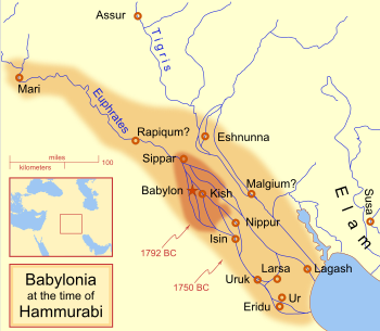
Wikipedia:Featured picture candidates/Babylonia in Hammurabi
Appearance
Voting period is over. Please don't add any new votes. Voting period ends on 24 Sep 2012 at 05:50:25 (UTC)

- Reason
- Good quality image, nice image of the Babylonia in the Hammurabi times.
- Articles in which this image appears
- Babylon, Babylonia, Eridu, Eshnunna, Hammurabi, Haradum, Isin, Kutha, Lagash, Larsa, List of kings of Babylon, Mashkan-shapir, Nippur, Samsu-iluna, Shaduppum, Shibaniba, Sippar, Sippar-Amnanum, Tell Agrab, Tell Ishchali
- FP category for this image
- Wikipedia:Featured pictures/Diagrams, drawings, and maps/Maps
- Creator
- User:MapMaster
- Support as nominator --Mediran talk 05:50, 15 September 2012 (UTC)
- Question is it significant that "The source code of this SVG is invalid"? Pine✉ 08:38, 16 September 2012 (UTC)
- Oppose for now: seems to be missing a few things (the SVG doesn't have to be valid, though - it's not really an important thing)
- The inset map, given that it doesn't include any water in the boxed area, I assume is a modern projection. However that really is a confusing disparity to the viewer and for this reason the modern inset map ought to be labelled as such.
- What are the lighter and darker coloured areas? I assume one is control, but I can't see an explanation as to which and what the other is.
- Is there a reason for the fuzzy border? It is already going to be assumed that this is approximate, so I don't think it's necessary to give a fuzz which might suggest the area of doubt is merely within that range (unless it is?).
- It could do with some sort of indication of date, which is only given in the two arrows.
- What are the two arrows?
- Why is the key in dark red and not black? Dark red is much harder to read on the yellow background.
- Is this the sum of current knowledge of Babylonian cities at the time (are their locations we know about missing)? At the moment it's a broad over-view, which is fine if it's all we have but if we can better that then we should, at least to some extent greater than this.
- Rapiqum and Malgium: is it the name of a city whose remains we have found that is unknown, or the location of a city whose name we know?
- What is Elam? Is it a geographical area or another civilisation? The answer to that may or may not present an opportunity to clarify that.
- The mapping conventions suggest a different town/city indication, for which I don't particularly care, but it would be nice to see the coastline outlined in dark(er) blue as suggested.
I've number these not to magnify their size (because I hope they can be resolved) but so the nominator or others can reply without interjecting into my list. Grandiose (me, talk, contribs) 13:52, 16 September 2012 (UTC)
- My comment.
- It is just fine that there are no blue lines/water, because those waters are rivers, like the river of Tigris and Euphrates, they are just rivers and cannot be seen on the box anyway.
- The darker area where Babylon, Sumer (includes Ur, Uruk, etc.) is placed is the area showing the Babylonian territory upon Hammurabi's ascension in 1792 BC and upon his death in 1750 BC.
- I dont know about the fuzzy border.
- Those dates are the dating of the territory of Babylon. In 1972 BC, (the area showing the darkest shade) is the territory of Babylon upon Hammurabi's ascension, while the 1750 BC (the area of lighter shade) is the territory of Babylon on Hammurabi's death.
- Those arrows indicate the territory of Babylon at a specific time.
- If it is black, it is harder for it to read. Red contrast yellow, so it is better than black.
- Well, those are the major city-states of Mesopotamia and it includes Babylon.
- Rapiqum and Malgium are city-states that are not yet located but are assumed to be located there.
- Elam was an ancient civilization centered in the far west and southwest of modern-day Iran.
- Yes, for me, it would also be nice to see the coastline outlined in dark blue.
--Mediran talk 10:16, 17 September 2012 (UTC)
- In reply to 1), I find it highly unlikely that the area to the south-east of the main map is a river, it looks like the sea.
- Oh, I see that the arrows are the definition of the areas. This is very unclear.
- 6)That's simply not true. Red on yellow has a poor contrast; black on yellow has the highest possible contrast.
- Rapiqum: is there some way that the map could show us that? If not, on the description page. Grandiose (me, talk, contribs) 14:19, 17 September 2012 (UTC)
- The sea at the right-most part at the bottom is a part of the Arabian Sea or the Gulf of Oman, I really don't know the name of the sea but it is not the river (Tigris & Euphrates), it is a sea. 6) Yes, as what you said, black and yellow has the highest possible contrast, but for me, the image is does not look good with those colors. --Mediran talk 11:36, 18 September 2012 (UTC)
Not Promoted --Makeemlighter (talk) 00:13, 25 September 2012 (UTC)
