Wilford Power Station
Appearance
| Wilford Power Station | |
|---|---|
 | |
 | |
| Country | England |
| Location | Nottinghamshire, East Midlands |
| Coordinates | 52°55′55″N 1°10′01″W / 52.931980°N 1.166837°W |
| Commission date | September 1925[1] |
| Decommission date | 1981 |
| Thermal power station | |
| Primary fuel | Coal |
| External links | |
| Commons | Related media on Commons |
grid reference SK561375 | |
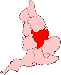
Wilford Power Station was a coal-fired power station situated on the north bank of the River Trent, at Nottingham in the East Midlands.
It was authorised in 1920. Construction took 5 years, cost £700,000 (equivalent to £50,430,000 in 2023) [2] and the first section was completed in September 1925. It was later expanded from the original 30MW to 316MW.
Much of the coal came from nearby Clifton Colliery and the power station had railway connections to the Nottingham branch of the Midland Main Line and the Great Central Railway. It provided power for Nottingham and the local surrounding area.
It closed in 1981 and was demolished shortly afterwards. The site has since been redeveloped and is now Riverside Retail Park.
See also
References
- ^ "New Power Station". Derby Daily Telegraph. British Newspaper Archive. 18 September 1925. p. 6. (subscription required)
- ^ UK Retail Price Index inflation figures are based on data from Clark, Gregory (2017). "The Annual RPI and Average Earnings for Britain, 1209 to Present (New Series)". MeasuringWorth. Retrieved 7 May 2024.
This article needs additional citations for verification. (September 2014) |
External links
- Photo of site now - Project documenting changes in Nottingham.
- Photo of the power station in 1947

