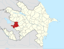
Zar, Azerbaijan
40°00′19″N 45°57′08″E / 40.00528°N 45.95222°E
Zar | |
|---|---|
| Country | |
| Rayon Province | Kalbajar Shahumian |
| Population (2005[1]) | |
• Total | 52 |
| Time zone | UTC+4 (AZT) |
| • Summer (DST) | UTC+5 (AZT) |
Zar (Template:Lang-hy, Tsar, also spelled Tzar or Car, Armenian pronunciation: [tsɑɾ]) is a village in the Kalbajar Rayon of Azerbaijan, currently under the control of the unrecognized Nagorno Karabakh Republic.
Etymology
Armenian architectural historian Samvel Karapetyan has written that name Zar is the Turkish pronunciation of the settlement's Armenian name Tsar which, due to its size, was still being referred to as Metsn Tzar (Great Tzar) as late as the eighteenth century.[2]
A popular Azeri legend gives an alternative origin. A poor young man named Zasa once lived in this village. He was in love with a girl named Nasy whose parents did not approve of their relationship. Zasa then decided to ask Nadir Shah for help. He planted a watermelon in a jar with a narrow neck. The surprised shah liked it and ordered Nasy to be given to Zasa. However, as soon as Nadir Shah left town, Nasy's family went to Zasa's house, killed him and threw his body into a well. After that, Zasa's mother wept for many days. The name Zar was said to have be derived from this legend because the Azerbaijani word zarıldamaq (zaryldamag) translates as "to sob."[3]
History
Zar's history goes back to the early medieval period, when it was the administrative center of the Karabakh Khanate province's canton of Tsar (which, until the eleventh to twelfth centuries, went by the name of Vaykunik').[4] In the fourteenth century, the Armenian Dop'ian family established itself in Tsar and remained there until its fortresses were devastated by the invasions of Tamerlane.[5] But the Armenian lords were able to recover by the fifteenth century, when Tsar was made the center for the Armenian meliks of Upper Khachen. In the sixteenth and seventeenth centuries, the town was enclosed by a line of walls and other defensive fortifications. In the 1730s and 1750s, a large number of Turkic tribes and Kurds from Iran established themselves in Tsar and subsequently renamed the village Zar.[6] In the early nineteenth century, the village was attacked and pillaged by the armies of the Ottoman Empire.[4]
Despite its ruinous state, in the late 1890s the scholar-bishop Makar Barkhudaryants was able to travel to Tsar and photograph the ruins of the monastery of the Holy Virgin (built in 1225), the chapels of Sts. Sargis and Grigor (built in 1274) and other medieval-era monuments (largely dating to the thirteenth and fifteenth centuries).[7]
Karapetyan has written that the Armenian monuments in Tsar (monasteries, churches and cemeteries) started to be destroyed by Kurds at the end of the nineteenth century, and that the destruction continued on a larger scale during the Soviet period and especially during the 1940s and 1950s. In particular, he documented that a school built in Zar in the 1950s was constructed using stones taken from the fourteenth-century Getamijo Surb Astvatsatsin (Holy Mother of God of the Confluence) Monastery that had stood at the edge of Tzar: he identified 133 carved or inscribed stone fragments reused within the walls of the school.[6][8] The village fell under the control of the Nagorno Karabakh Republic in 1993.
Landmarks
Gallery
-
A sign in Armenian denoting the boundary limit of Tsar.
-
A monument built in honor of the Armenian troops who died in the Nagorno-Karabakh War.
-
One of canyons that surround the village.
-
Ruins of the village school built in the 1950s and containing stones taken from an Armenian monastery..
-
Fragments of Armenian gravestones.
-
Ruins of Armenian churches.
-
Ornaments on the wall of the Chapel of St. Sargis.
Notes
- ^ Results of 2005 census of the Nagorno-Karabakh Republic
- ^ Karapetyan, Samvel. Armenian Cultural Monuments in the Region of Karabakh. Trans. Anahit Martirossian. Yerevan: Gitutiun Publishing House of NAS RAA, 2001, p. 13.
- ^ G. Arasly (1982). Библиотека азербайджанской классической литературы в 20 томах (in Russian). Baku: Nauka. p. 52.
{{cite book}}: Unknown parameter|trans_title=ignored (|trans-title=suggested) (help) - ^ a b Template:Hy icon Ulubabyan, Bagrat. «Ծար» (Tsar). Armenian Soviet Encyclopedia. Yerevan: Armenian Academy of Sciences, 1979, vol. 5, p. 120.
- ^ Karapetyan. Armenian Cultural Monuments, p. 11.
- ^ a b Hovhannisyan, Hasmik. "New Shahumyan." Hetq. July 23, 2007. Retrieved December 8, 2010.
- ^ For these photographs, see Template:Hy icon Makar Barkhudaryants, Արցախ (Artsakh). Baku, 1895.
- ^ Karapetian. Armenian Cultural Monuments, pp. 50-65.
Further reading
- Karapetyan, Samvel. Armenian Cultural Monuments in the Region of Karabakh. Trans. Anahit Martirossian. Yerevan: Gitutiun Publishing House of NAS RAA, 2001.
- Template:Hy icon Ulubabyan, Bagrat. Խաչենի իշխանությունը, X-XVI դարերում (The Principality of Khachen, From the 10th to 16th centuries). Yerevan, Armenian SSR: Armenian Academy of Sciences, 1975.


