
Zhnyborody
Zhnyborody
Жнибороди | |
|---|---|
 | |
| Coordinates: 48°54′01″N 25°26′24″E / 48.90028°N 25.44000°E | |
| Country | |
| Oblast | |
| Raion | Buchach Raion |
| Area | |
| • Total | 0.920 km2 (0.355 sq mi) |
| Population | |
| • Total | 721 |
| • Density | 1,315/km2 (3,410/sq mi) |
| Time zone | UTC+2 (EET) |
| • Summer (DST) | UTC+3 (EEST) |
| Postal code | 48474 |
| Area code | +380 3544 |
| Website | zhnyborody.te.ua |
Zhnyborody (Ukrainian: Жнибороди; Polish: Żnibrody; Russian: Жнибороды) is a village in the Buchach Raion (district) of the Ternopil Oblast (province) in western Ukraine.
History
First written mention comes from the 15th century, naming Niezbrody. Zhnyborody belonged to the Kingdom of Poland, the Polish-Lithuanian Commonwealth, from 1772 until 1918 to Austrian (Habsburg Monarchy, Austrian Empire, Austria-Hungary) empires, in 1918-1919 to West Ukrainian People's Republic. From 1991 belonged to Ukraine.
-
 Fragment Franciscan birth-certificate w. Zhnyborody.
 -
 Fragment Yosyfinskian birth-certificate w. Zhnyborody.


Religion
-
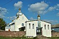 Church of saint Mihael UGCC.
 -
 Chapel at an entrance in the Zhnyborody from the w. Duliby.


Social sphere
-
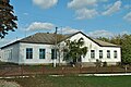 School in Zhnyborody.
 -
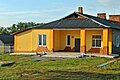 Preschool educational establishment «Prominchyk».
 -
 Shop.
Shop.


Nature
-
 A kind is on a village. A natural boundary is «Proval».
 -
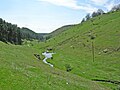 A kind is on a village. A natural boundary is «Proval».
 -
 A lizard is in a lithoidal quarry near-by a natural boundary «Virlyska» on the western fence surrounding village.
 -
 Starling.
 -
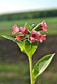 Pulmonaria.
_-_12109628.jpg)


Sources
- (in Ukrainian) М. Василечко, Жнибороди // Ternopil Encyclopedic Dictionary: in 4 v. / editorial board: H. Yavorskyi and other, Ternopil: "Zbruch", 2004, V. 1: А—Й, S. 578. — ISBN 966-528-197-6.
External links
Wikimedia Commons has media related to Zhnyborody.

This article about a location in Ternopil Oblast is a stub. You can help Wikipedia by expanding it. |