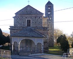
Andrate
Appearance
Andrate | |
|---|---|
| Comune di Andrate | |
 | |
| Coordinates: 45°32′N 7°52′E / 45.533°N 7.867°E | |
| Country | Italy |
| Region | Piedmont |
| Metropolitan city | Turin (TO) |
| Government | |
| • Mayor | Enrico Bovo |
| Area | |
| • Total | 9.31 km2 (3.59 sq mi) |
| Elevation | 820 m (2,690 ft) |
| Population (30 November 2017)[2] | |
| • Total | 489 |
| • Density | 53/km2 (140/sq mi) |
| Demonym | Andratesi |
| Time zone | UTC+1 (CET) |
| • Summer (DST) | UTC+2 (CEST) |
| Postal code | 10010 |
| Dialing code | 0125 |
| Website | Official website |
Andrate (Piedmontese: Andrà) is a comune (municipality) in the Metropolitan City of Turin in the Italian region Piedmont, located about 50 kilometres (31 mi) north of Turin.
Andrate borders the following municipalities: Settimo Vittone, Donato, Nomaglio, Borgofranco d'Ivrea, and Chiaverano. It is located at the top of the Moraine of Ivrea, with elevations ranging from 550 to 2,227 meters above the sea level.
The name of this town may have Celtic origins. It may come from the words and (end) and art (land).
References
[edit]- ^ "Superficie di Comuni Province e Regioni italiane al 9 ottobre 2011". Italian National Institute of Statistics. Retrieved 16 March 2019.
- ^ All demographics and other statistics: Italian statistical institute Istat.


