
Budětice
Budětice | |
|---|---|
.jpg) Centre of Budětice | |
 Flag  Coat of arms | |
 Budětice Location in the Czech Republic | |
| Coordinates: 49°17′0″N 13°35′5″E / 49.28333°N 13.58472°E | |
| Country | |
| Region | Plzeň |
| District | Klatovy |
| First mentioned | 1290 |
| Area | |
| • Total | 13.46 km2 (5.20 sq mi) |
| Elevation | 495 m (1,624 ft) |
| Population (2023-01-01)[1] | |
| • Total | 294 |
| • Density | 22/km2 (57/sq mi) |
| Time zone | UTC+1 (CET) |
| • Summer (DST) | UTC+2 (CEST) |
| Postal codes | 341 01, 342 01 |
| Website | www |
Budětice is a municipality and village in Klatovy District in the Plzeň Region of the Czech Republic. It has about 300 inhabitants.
Budětice lies approximately 25 kilometres (16 mi) south-east of Klatovy, 54 km (34 mi) south of Plzeň, and 108 km (67 mi) south-west of Prague.
Administrative parts[edit]
The villages of Lipová Lhota and Vlkonice are administrative parts of Budětice.
Demographics[edit]
| Year | Pop. | ±% |
|---|---|---|
| 1869 | 923 | — |
| 1880 | 934 | +1.2% |
| 1890 | 873 | −6.5% |
| 1900 | 829 | −5.0% |
| 1910 | 831 | +0.2% |
| 1921 | 857 | +3.1% |
| 1930 | 731 | −14.7% |
| 1950 | 511 | −30.1% |
| 1961 | 512 | +0.2% |
| 1970 | 432 | −15.6% |
| 1980 | 373 | −13.7% |
| 1991 | 364 | −2.4% |
| 2001 | 315 | −13.5% |
| 2011 | 273 | −13.3% |
| 2021 | 303 | +11.0% |
| Source: Censuses[2][3] | ||
Gallery[edit]
-
 Church of Saints Peter and Paul
 -
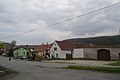 Centre of Budětice
 -
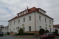 Municipal office
,_kostel_sv._Petra_a_Pavla_od_jihu.JPG)


References[edit]
- ^ "Population of Municipalities – 1 January 2023". Czech Statistical Office. 2023-05-23.
- ^ "Historický lexikon obcí České republiky 1869–2011 – Okres Klatovy" (in Czech). Czech Statistical Office. 2015-12-21. pp. 1–2.
- ^ "Population Census 2021: Population by sex". Public Database. Czech Statistical Office. 2021-03-27.
External links[edit]
Wikimedia Commons has media related to Budětice.
| Authority control databases: National |
|---|
This Plzeň Region location article is a stub. You can help Wikipedia by expanding it. |