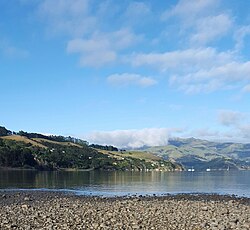
Takamatua
Takamatua | |
|---|---|
 Takamatua Bay | |
 | |
| Coordinates: 43°47′0″S 172°58′15″E / 43.78333°S 172.97083°E | |
| Country | New Zealand |
| Region | Canterbury Region |
| District | Christchurch City |
| Ward | Banks Peninsula |
| Community | Te Pātaka o Rākaihautū Banks Peninsula |
| Electorates |
|
| Government | |
| • Territorial Authority | Christchurch City Council |
| • Regional council | Environment Canterbury |
| • Mayor of Christchurch | Phil Mauger |
| • Banks Peninsula MP | Vanessa Weenink |
| • Te Tai Tonga MP | Tākuta Ferris |
| Area | |
• Total | 6.30 km2 (2.43 sq mi) |
| Population (June 2024)[2] | |
• Total | 110 |
| • Density | 17/km2 (45/sq mi) |
| Postcode | 7581 |
Takamatua, with an initial European name of German Bay, is a small town situated in Akaroa Harbour on Banks Peninsula in New Zealand. The main road to Akaroa (State Highway 75) passes through this locality. It is 3 kilometres (1.9 mi) north of Akaroa township.[3]
History
[edit]At the time of French settlement in August 1840 in Akaroa, a small number of German families settled in this bay.[4] Five German men, four of them single, chose to have land in Takamatua rather than Akaroa. The men were Breitmeyer, Hahn, Hettich, Waeckerle, Walther and Woll. [5] The bay was named German Bay up until 1916 when the residents called on the Minister for Internal Affairs, George Warren Russell, to change the name to Takamatua, as a patriotic reaction to World War I.[6] The German Bay Dairy Co-operative Factory was established in 1893.[7] The Factory's cheese won first prize at the Dunedin Agricultural Show in 1901 and 1902.[7][8]
Demographics
[edit]Takamatua is described by Statistics New Zealand as a rural settlement, and covers 6.30 km2 (2.43 sq mi).[1] It had an estimated population of 110 as of June 2024,[2] with a population density of 17 people per km2. It is part of the statistical area of Akaroa Harbour.[9]
| Year | Pop. | ±% p.a. |
|---|---|---|
| 2006 | 111 | — |
| 2013 | 135 | +2.84% |
| 2018 | 111 | −3.84% |
| Source: [10] | ||


Takamatua had a population of 111 at the 2018 New Zealand census, a decrease of 24 people (−17.8%) since the 2013 census, and unchanged since the 2006 census. There were 45 households, comprising 57 males and 54 females, giving a sex ratio of 1.06 males per female. The median age was 61.8 years (compared with 37.4 years nationally), with 12 people (10.8%) aged under 15 years, 3 (2.7%) aged 15 to 29, 54 (48.6%) aged 30 to 64, and 42 (37.8%) aged 65 or older.
Ethnicities were 94.6% European/Pākehā, 10.8% Māori, 5.4% Asian, and 2.7% other ethnicities. People may identify with more than one ethnicity.
Although some people chose not to answer the census's question about religious affiliation, 43.2% had no religion, 37.8% were Christian, 5.4% had Māori religious beliefs, and 2.7% were Buddhist.
Of those at least 15 years old, 18 (18.2%) people had a bachelor's or higher degree, and 18 (18.2%) people had no formal qualifications. The median income was $28,600, compared with $31,800 nationally. 9 people (9.1%) earned over $70,000 compared to 17.2% nationally. The employment status of those at least 15 was that 36 (36.4%) people were employed full-time, and 24 (24.2%) were part-time.[10]
References
[edit]- ^ a b "ArcGIS Web Application". statsnz.maps.arcgis.com. Retrieved 15 October 2021.
- ^ a b "Aotearoa Data Explorer". Statistics New Zealand. Retrieved 26 October 2024.
- ^ Reed New Zealand atlas (2004) Auckland: Reed Publishing. Map 83. ISBN 0 7900 0952 8
- ^ Reed, A. W. (1975). The Reed Dictionary of New Zealand Place Names. Auckland: Reed. p. 481. ISBN 0-7900-0761-4.
- ^ Tremewan, Peter (1990). French Akaroa. Christchurch: Canterbury University Press. p. 145. ISBN 978-1-877257-97-1.
- ^ "Deleted from map: German Bay, Akaroa". Evening Post. 5 January 1916. Retrieved 17 September 2018 – via Papers Past.
- ^ a b "German Bay". The Cyclopedia of New Zealand. Vol. 3 Canterbury Provincial District. 1903. Retrieved 17 September 2018 – via NZETC.
- ^ "Otago Winter Show". The Akaroa Mail. 1 July 1902. Retrieved 17 September 2018 – via Papers Past.
- ^ 2018 Census place summary: Akaroa Harbour
- ^ a b "Statistical area 1 dataset for 2018 Census". Statistics New Zealand. March 2020. 7026659.
Further reading
[edit]- Dykes, G.A. A History of the German Bay / Takamatua School 1876 - 1936 [1] (history of both the school and the wider Takamatua community)
