
Kampuchea Krom: Difference between revisions
tidying of ancient polities line |
→Background: Added in new sections on territorial history, environment, and infrastructure |
||
| Line 1: | Line 1: | ||
| ⚫ | [[File:Kampuchea Krom Location.png|thumb|Kampuchea Krom marked with red on the map of Indochina.|299x299px]]'''Kampuchea Krom''' ({{lang-km|កម្ពុជាក្រោម}}, {{transl|km|Kămpŭchéa Kraôm}}) is the region variously known as southern Vietnam, Nam Bo, and the former French Cochinchina.<ref name=":0">{{Cite book|last=Taylor|first=Philip|url=http://worldcat.org/oclc/1002061468|title=The Khmer lands of Vietnam : environment, cosmology, and sovereignty|publisher=National University of Singapore Press|year=2014|pages=1|oclc=1002061468}}</ref> Bordering present-day [[Cambodia]], the region is positioned in Cambodian nationalist mythology as a "once-integral part of the Khmer kingdom that was colonised by France as [[Cochinchina]] in the mid-nineteenth century, then wrongfully ceded to Vietnam in June 1949".<ref name=":1">{{Cite book|last=Taylor|first=Philip|url=http://worldcat.org/oclc/1002061468|title=The Khmer lands of Vietnam : environment, cosmology, and sovereignty|publisher=NUS Press|year=2014|pages=2|oclc=1002061468}}</ref> In the present day, the region roughly corresponds to the [[Mekong Delta]] region of Vietnam. |
||
| ⚫ | '''Kampuchea Krom''' ({{lang-km|កម្ពុជាក្រោម}}, {{transl|km|Kămpŭchéa Kraôm}}) is the region variously known as southern Vietnam, Nam Bo, and the former French Cochinchina.<ref name=":0">{{Cite book|last=Taylor|first=Philip|url=http://worldcat.org/oclc/1002061468|title=The Khmer lands of Vietnam : environment, cosmology, and sovereignty|publisher=National University of Singapore Press|year=2014|pages=1|oclc=1002061468}}</ref> Bordering present-day [[Cambodia]], the region is positioned in Cambodian nationalist mythology as a "once-integral part of the Khmer kingdom that was colonised by France as [[Cochinchina]] in the mid-nineteenth century, then wrongfully ceded to Vietnam in June 1949".<ref name=":1">{{Cite book|last=Taylor|first=Philip|url=http://worldcat.org/oclc/1002061468|title=The Khmer lands of Vietnam : environment, cosmology, and sovereignty|publisher=NUS Press|year=2014|pages=2|oclc=1002061468}}</ref> In the present day, the region roughly corresponds to the [[Mekong Delta]] region of Vietnam. |
||
Kampuchea Krom continues to be home to many ethnic [[Khmer Krom]], with some [[Khmer people|Khmer]] estimating their numbers to be between seven million and over ten million.<ref name=":1" /> The Khmer term "Kampuchea Krom" can be translated as “Lower Cambodia”.<ref name=":1" /> An alternative name for the region is Kampuchea Lik Tuk, which roughly corresponds to "Flooded Cambodia".<ref name=":1" /> |
Kampuchea Krom continues to be home to many ethnic [[Khmer Krom]], with some [[Khmer people|Khmer]] estimating their numbers to be between seven million and over ten million.<ref name=":1" /> The Khmer term "Kampuchea Krom" can be translated as “Lower Cambodia”.<ref name=":1" /> An alternative name for the region is Kampuchea Lik Tuk, which roughly corresponds to "Flooded Cambodia".<ref name=":1" /> |
||
==Territorial History== |
|||
[[File:Kampuchea Krom Location.png|thumb|Kampuchea Krom marked with red on the map of Indochina.]] |
|||
| ⚫ | In a Khmer Buddhist monk's vision, the Khmer have inhabited the land of Kampuchea Krom since it first emerged from the ocean thousands of years ago as a fragrant and glowing land that attracted the ''teovada'', celestial beings who ate the sweet earth and were subsequently unable to fly back to their world, thus staying on earth as the first humans.<ref name=":0" /> Throughout history, the area known in Khmer as Kampuchea Krom has been situated within numerous ancient polities, including Nokor Phnom ([[Funan]]), [[Chenla]], and the [[Khmer Empire]].<ref name="SPKKF">{{Cite web|authors=Scott, Peter and the KKF Research Team|date=December 29, 2012|title=A Brief History of the Kampuchea-Krom: The Khmer-Krom Journey to Self-Determination|url=https://khmerkrom.org/a-brief-history-of-the-kampuchea-krom/|access-date=April 29, 2019|website=KKF {{!}} Khmers Kampuchea-Krom Federation|language=en-US}}</ref> |
||
=== Ancient Civilizations === |
|||
Archaeological research at the [[Óc Eo]] site between [[Rạch Giá]] and [[Long Xuyên]] in present South Vietnam dates Vietnamese occupation in the region to the 16th century, prior to which the area was located within the ancient [[Khmer Empire|Khmer empire]].<ref name=":2">{{Cite book|last=Haksrea|first=Kuoch|title=Survey of the Southern Provinces of Cambodia in the Pre-Angkor Period|publisher=[Thesis] School of Oriental and African Studies, University of London|year=June 1976|pages=29}}</ref> There is no clear consensus on the ethnic makeup of those living within the region during the earlier Funan and Chenla polities.<ref name=":3">{{Cite book|last=Goh|first=Geok Yian|title=Ancient Southeast Asia|last2=Miksic|first2=John Norman|publisher=Routledge|year=2017|pages=49}}</ref> Linguistic evidence from the period - by way of inscriptions - supports the theory that inhabitants spoke a pre-Khmer [[Austronesian languages|Austronesian language]].<ref name=":2" /> However, archaeologists and historians also contend that this language may have been similar to Khmer, and that a version of Old Khmer may have been used by the end of the Funan period.<ref name=":2" /> A further theory is that ethnic distribution within the region may have varied with elevation within the landscape, with Khmer speakers living on higher ground, and Malayo-Polynesian - and later Vietnamese - speakers occupying the lower-lying areas.<ref name=":3" /> |
|||
=== Vietnamese Expansion === |
|||
| ⚫ | |||
| ⚫ | By the 1620s, Vietnamese’s “march to the south” (nam tien) began expanding south, by first conquered the [[Champa]] before continuing south bringing Vietnamese colonization into Kampuchea Krom.<ref name="Chandler4">{{Cite book|last=Chandler|first=David|title=A History of Cambodia|publisher=Westview Press|year=2008|edition=4th}}</ref><ref>{{Cite book|last=Hinton|first=Alexander Laban|title=Why did they kill?: Cambodia in the shadow of genocide|publisher=University of California Press|year=2005}}</ref><ref>{{Cite book|last=Chanda|first=Nayan|title=Brother enemy : the war after the war|date=1986|publisher=Collier Books}}</ref> |
||
| ⚫ | In 1623, when the [[Khmer Empire]] began to decline, at the request of Vietnamese missionary, King [[Chey Chettha II|Chey Chettha]] (1618–1628) of Cambodia allowed [[Name of Vietnam|Annamese]] to settle in the south part of Cambodia, the area around Prey Nokor.<ref name="TrNg2" /><ref name="Tarling CHSA">{{Cite book|last=Tarling|first=Nicholas|title=The Cambridge history of Southeast Asia|date=2000|publisher=Cambridge University Press}}</ref> |
||
| ⚫ | |||
| ⚫ | |||
| ⚫ | Vietnamese expansion into Prey Nokor and Kampuchea Krom territory, stressed by Chandler, took more than two hundred years, and to a large extent cut Cambodia off from gaining maritime access to the outside world, removed tens of thousands of Khmer ethnics from Cambodian jurisdiction.<ref name="Chandler4" /> |
||
| ⚫ | |||
The [[Nguyễn dynasty|Nguyễn Dynasty]] of the 19th century saw Kampuchea Krom become the subject of intensified territorial contests between the Vietnamese and Siamese states. In particular, the 1809 death of [[Mạc Thiên Tứ|Mạc Tử Thiêm]] in 1809 brought an end to the autonomous status of the [[Principality of Hà Tiên|Hà Tiên principality]], and saw its incorporation under Vietnamese control, serving as a buffer zone against the Siamese state.<ref>{{Cite journal|last=Liêm|first=Vũ Đức|date=2016|title=Vietnam at the Khmer Frontier: Boundary Politics, 1802–1847|url=http://dx.doi.org/10.1353/ach.2016.0018|journal=Cross-Currents: East Asian History and Culture Review|volume=5|issue=2|pages=537|doi=10.1353/ach.2016.0018|issn=2158-9674}}</ref> |
|||
== Environment and Infrastructure == |
|||
As implied by its alternate name of Kampuchea Lik Tuk, or "Flooded Cambodia", Kampuchea Krom sees an abundance of water, with events like high flooding, high rainfall, and seawater incursions varying with the seasons.<ref>{{Cite book|last=Taylor|first=Philip|url=http://worldcat.org/oclc/1002061468|title=The Khmer lands of Vietnam : environment, cosmology, and sovereignty|publisher=National University of Singapore Press|year=2014|pages=7|oclc=1002061468}}</ref> The abundance of water brought by these events, together with the natural flat plain that characterizes its region, makes it a productive agricultural area with rich, fertile soils.<ref>{{Citation|last=Campbell|first=Ian C.|title=Biodiversity of the Mekong Delta|date=2012|url=http://dx.doi.org/10.1007/978-94-007-3962-8_11|work=Springer Environmental Science and Engineering|pages=293–313|place=Dordrecht|publisher=Springer Netherlands|isbn=978-94-007-3961-1|access-date=2021-04-11}}</ref> However, its swampy and amphibious nature, accompanied by seasonal dry spells, have resulted in researchers' characterization of the region as resistant to human settlement, with significant infrastructural development required to make permanent settlement possible.<ref>{{Cite book|last=Brocheux|first=Pierre|title=The Mekong Delta: Ecology, Economy, and Revolution, 1860-1960|publisher=Center for Southeast Asian Studies, University of Wisconsin-Madison|year=1995|pages=2}}</ref> <ref>{{Cite book|last=Biggs|first=David|title=Quagmire: Nation-Building and Nature in the Mekong Delta|publisher=University of Washington Press|year=2010|pages=6}}</ref> |
|||
=== Precipitation === |
|||
==Background== |
|||
[[File:Vietnam Mekong Delta administrative map.jpg|alt=A map of the lower Mekong Delta, demarcated by the various Vietnamese administrative areas. The provinces of Vinh Long and Tra Vinh, situated between the Mekong and Bassac rivers, constitute the northern coastal complex identified by Taylor.|thumb|329x329px|Vietnamese Adminstrative Map of the Lower Mekong Delta; The northern coastal complex identified by Taylor corresponds to Vinh Long and Tra Vinh provinces on the map.]] |
|||
| ⚫ | In a Khmer Buddhist monk's vision, the Khmer have inhabited the land of Kampuchea Krom since it first emerged from the ocean thousands of years ago as a fragrant and glowing land that attracted the ''teovada'', celestial beings who ate the sweet earth and |
||
Anthropologist Philip Taylor's ethnographic text on Khmer communities within Kampuchea Krom identifies a number of strategies employed by the Khmer to utilize local precipitation for the purposes of agriculture and consumption, even during the dry season.<ref>{{Cite book|last=Taylor|first=Philip|url=http://worldcat.org/oclc/1002061468|title=The Khmer lands of Vietnam : environment, cosmology, and sovereignty|publisher=National University of Singapore Press|year=2014|oclc=1002061468}}</ref> These strategies differ across its geomorphically distinct sub-regions. Two sub-regions where the harvesting of local precipitation were identified by Taylor as significant are the northern coastal complex and the saltwater river region. |
|||
Throughout history, Kampuchea Krom has been situated within numerous ancient polities, including Nokor Phnom ([[Funan]]), [[Chenla]], and the [[Khmer Empire]].<ref name=SPKKF/> |
|||
==== Northern Coastal Complex ==== |
|||
According to Vietnam History book,<ref name=TrNg2-TTK>{{Cite book |title=Vietnam Sử Lược |authors= Tran Trong Kim |year=1964}}</ref> |
|||
The northern coastal complex is a "flange of flat, salt-impregnated land lying between the mouths of the Mekong and Bassac Rivers and bounded by the ocean to the east", an area often perceived as the "quintessential Khmer region of Vietnam" by researchers and tourists alike.<ref>{{Cite book|last=Philip|first=Taylor|url=http://worldcat.org/oclc/1002061468|title=The Khmer lands of Vietnam : environment, cosmology, and sovereignty|pages=31|oclc=1002061468}}</ref> The region sees annual wet and dry seasons. Its rainy season lasts from May to December and covers the majority of the region with water.<ref name=":4">{{Cite book|last=Philip|first=Taylor|url=http://worldcat.org/oclc/1002061468|title=The Khmer lands of Vietnam : environment, cosmology, and sovereignty|pages=33|oclc=1002061468}}</ref> During the dry season however, soil surfaces crack and drinking water becomes extremely scarce.<ref name=":4" /> |
|||
the territory of Kampuchea Krom around the lower plains of the Mekong River is rich in waterways and has many farmlands. |
|||
| ⚫ | |||
| ⚫ | By the 1620s, Vietnamese’s “march to the south” (nam tien) began expanding south, by first conquered the [[Champa]] before continuing south bringing Vietnamese colonization into Kampuchea Krom.<ref name=Chandler4>{{Cite book |
||
| ⚫ | In 1623, when the [[Khmer Empire]] began to decline, at the request of Vietnamese missionary, King [[Chey Chettha II|Chey Chettha]] (1618–1628) of Cambodia allowed [[Name of Vietnam|Annamese]] to settle in the south part of Cambodia, the area around Prey Nokor.<ref name=TrNg2/><ref name="Tarling CHSA">{{Cite book| |
||
| ⚫ | |||
| ⚫ | |||
Taylor identifies the ''phno'', or "elevated ridges of coarse sandy soil, between one to five metres high", as crucial to the sustenance of life within the northern coastal complex, constituting both cosmological and strategic significance for the Khmers in the region.<ref name=":4" /> According to Taylor's interlocuter, a [[Pali]] teacher in the region, the ''phno'' were the first land to emerge, and comprised the ancient lands of [[Suvarnabhumi|Suvannaphum]] through which the Buddha traversed in his travels across the world.<ref>{{Cite book|last=Taylor|first=Philip|url=http://worldcat.org/oclc/1002061468|title=The Khmer lands of Vietnam : environment, cosmology, and sovereignty|pages=37-8|oclc=1002061468}}</ref> |
|||
| ⚫ | Vietnamese expansion into Prey Nokor and Kampuchea Krom territory, stressed by Chandler, took more than two hundred years, and to a large extent cut Cambodia off from gaining maritime access to the outside world, removed tens of thousands of Khmer ethnics from Cambodian jurisdiction.<ref name=Chandler4/> |
||
| ⚫ | |||
==Areas== |
==Areas== |
||
Revision as of 10:47, 11 April 2021

Kampuchea Krom (Khmer: កម្ពុជាក្រោម, Kămpŭchéa Kraôm) is the region variously known as southern Vietnam, Nam Bo, and the former French Cochinchina.[1] Bordering present-day Cambodia, the region is positioned in Cambodian nationalist mythology as a "once-integral part of the Khmer kingdom that was colonised by France as Cochinchina in the mid-nineteenth century, then wrongfully ceded to Vietnam in June 1949".[2] In the present day, the region roughly corresponds to the Mekong Delta region of Vietnam.
Kampuchea Krom continues to be home to many ethnic Khmer Krom, with some Khmer estimating their numbers to be between seven million and over ten million.[2] The Khmer term "Kampuchea Krom" can be translated as “Lower Cambodia”.[2] An alternative name for the region is Kampuchea Lik Tuk, which roughly corresponds to "Flooded Cambodia".[2]
Territorial History
In a Khmer Buddhist monk's vision, the Khmer have inhabited the land of Kampuchea Krom since it first emerged from the ocean thousands of years ago as a fragrant and glowing land that attracted the teovada, celestial beings who ate the sweet earth and were subsequently unable to fly back to their world, thus staying on earth as the first humans.[1] Throughout history, the area known in Khmer as Kampuchea Krom has been situated within numerous ancient polities, including Nokor Phnom (Funan), Chenla, and the Khmer Empire.[3]
Ancient Civilizations
Archaeological research at the Óc Eo site between Rạch Giá and Long Xuyên in present South Vietnam dates Vietnamese occupation in the region to the 16th century, prior to which the area was located within the ancient Khmer empire.[4] There is no clear consensus on the ethnic makeup of those living within the region during the earlier Funan and Chenla polities.[5] Linguistic evidence from the period - by way of inscriptions - supports the theory that inhabitants spoke a pre-Khmer Austronesian language.[4] However, archaeologists and historians also contend that this language may have been similar to Khmer, and that a version of Old Khmer may have been used by the end of the Funan period.[4] A further theory is that ethnic distribution within the region may have varied with elevation within the landscape, with Khmer speakers living on higher ground, and Malayo-Polynesian - and later Vietnamese - speakers occupying the lower-lying areas.[5]
Vietnamese Expansion
Vietnamese first known to have encroached into Kampuchea Krom territory in the early 1600s at Baria and Daun Nay due to famine caused by nonfertile land in Annam and the war between Trinh and Nguyen.[6] By the 1620s, Vietnamese’s “march to the south” (nam tien) began expanding south, by first conquered the Champa before continuing south bringing Vietnamese colonization into Kampuchea Krom.[7][8][9] In 1623, when the Khmer Empire began to decline, at the request of Vietnamese missionary, King Chey Chettha (1618–1628) of Cambodia allowed Annamese to settle in the south part of Cambodia, the area around Prey Nokor.[10][11] In this regard, some foreign historians see this as ‘a conquer of Cambodian trading center (by Vietnamese) with concealed motives’.[12] In 1628, waves of Vietnamese immigrants flooded into the regions from Prey Nokor, Baria, and Daun Nay (Kampong Sroka Trei) to the former Champa Kingdom.[10]
Vietnamese expansion into Prey Nokor and Kampuchea Krom territory, stressed by Chandler, took more than two hundred years, and to a large extent cut Cambodia off from gaining maritime access to the outside world, removed tens of thousands of Khmer ethnics from Cambodian jurisdiction.[7] In 1953, Cambodians in Kampuchea Krom stood at some four hundred thousand, less than 10% of Vietnamese.[7]
The Nguyễn Dynasty of the 19th century saw Kampuchea Krom become the subject of intensified territorial contests between the Vietnamese and Siamese states. In particular, the 1809 death of Mạc Tử Thiêm in 1809 brought an end to the autonomous status of the Hà Tiên principality, and saw its incorporation under Vietnamese control, serving as a buffer zone against the Siamese state.[13]
Environment and Infrastructure
As implied by its alternate name of Kampuchea Lik Tuk, or "Flooded Cambodia", Kampuchea Krom sees an abundance of water, with events like high flooding, high rainfall, and seawater incursions varying with the seasons.[14] The abundance of water brought by these events, together with the natural flat plain that characterizes its region, makes it a productive agricultural area with rich, fertile soils.[15] However, its swampy and amphibious nature, accompanied by seasonal dry spells, have resulted in researchers' characterization of the region as resistant to human settlement, with significant infrastructural development required to make permanent settlement possible.[16] [17]
Precipitation

Anthropologist Philip Taylor's ethnographic text on Khmer communities within Kampuchea Krom identifies a number of strategies employed by the Khmer to utilize local precipitation for the purposes of agriculture and consumption, even during the dry season.[18] These strategies differ across its geomorphically distinct sub-regions. Two sub-regions where the harvesting of local precipitation were identified by Taylor as significant are the northern coastal complex and the saltwater river region.
Northern Coastal Complex
The northern coastal complex is a "flange of flat, salt-impregnated land lying between the mouths of the Mekong and Bassac Rivers and bounded by the ocean to the east", an area often perceived as the "quintessential Khmer region of Vietnam" by researchers and tourists alike.[19] The region sees annual wet and dry seasons. Its rainy season lasts from May to December and covers the majority of the region with water.[20] During the dry season however, soil surfaces crack and drinking water becomes extremely scarce.[20]
Taylor identifies the phno, or "elevated ridges of coarse sandy soil, between one to five metres high", as crucial to the sustenance of life within the northern coastal complex, constituting both cosmological and strategic significance for the Khmers in the region.[20] According to Taylor's interlocuter, a Pali teacher in the region, the phno were the first land to emerge, and comprised the ancient lands of Suvannaphum through which the Buddha traversed in his travels across the world.[21]
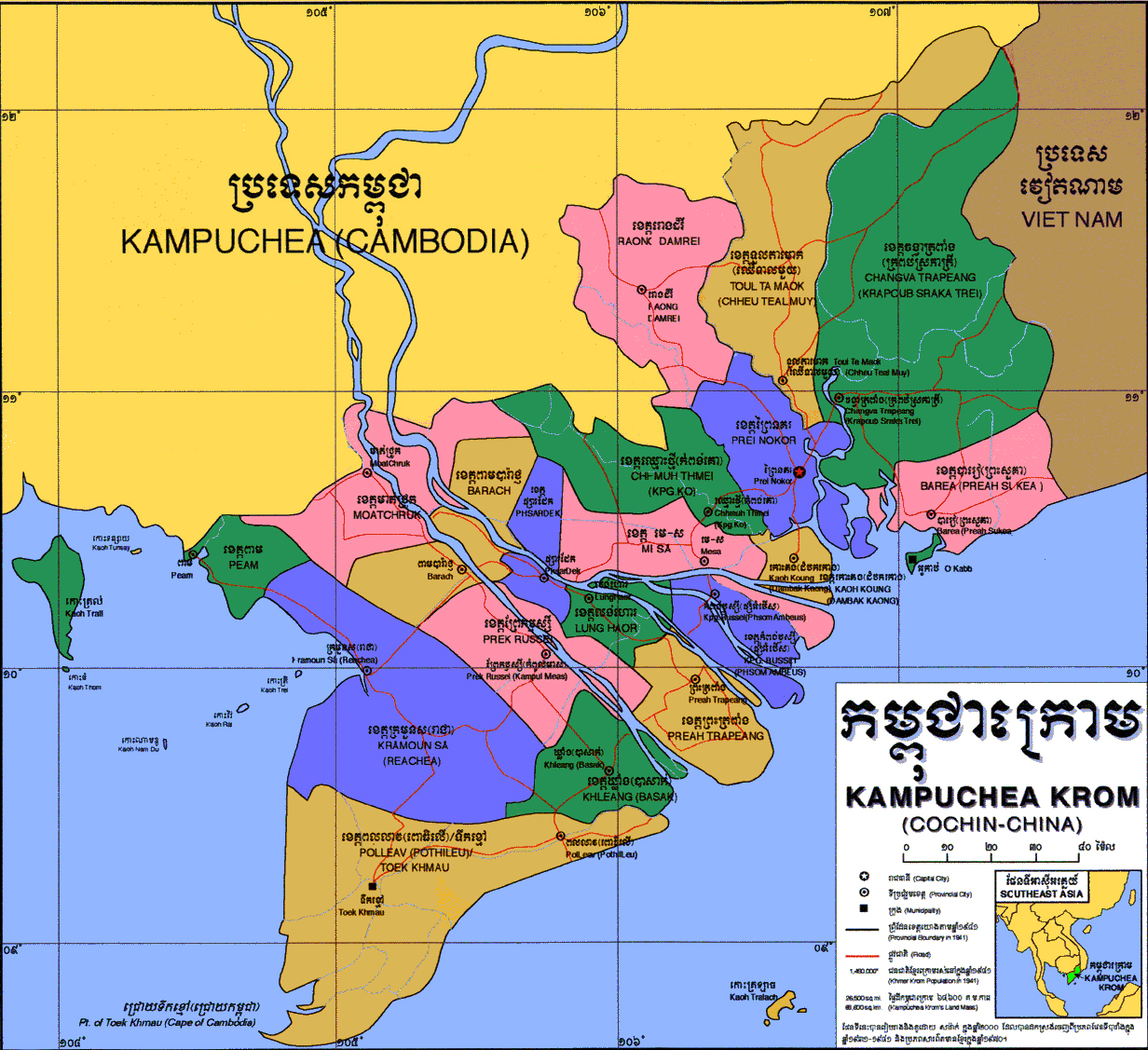
Areas
Kampuchea Krom was originally divided into only four provinces Daun Nay, Lung Haor, Moat Chrouk, and Peam.[22] According to Cambodian sources, it now covers approximately the areas of twenty-one Vietnamese districts.[23][22][24]
According to Cambodian sources, the Khmer names of the local divisions have been continually renamed by Vietnamese authorities.[22][25] Vietnamese names are seen as a calque of the original Khmer names such as Sa Đéc (Khmer: Psar Dek), Sóc Trăng (Khmer: Srok Kleang), Trà Vinh (Khmer: Preah Tropeang), Bạc Liêu (Khmer: Pol Leav), Cà Mau (Khmer: Toek Khmao), Mỹ Tho (Khmer: Me Sar);[25] Đồng Nai (Khmer: Daun Nay).[23] Some Vietnamese names were translated from the meaning of the original Khmer names such as Bến Tre (Khmer: Kampong Russei), Bến Nghé (Khmer: Kampong Krobei).[25]
| No. | Khmer | Latin | Vietnamese | Vietnamese Province/City | Inclusion into Vietnam |
|---|---|---|---|---|---|
| Provinces/City in the Southeast Region | |||||
| 1 | ព្រៃនគរ | Prey Nokor | Gia Định / Sài Gòn (later: Hồ Chí Minh) | Hồ Chí Minh | c.1696; 1699 |
| 2 | ព្រះសួគ៌ា | Preah Suorkea | Bà Rịa | Bà Rịa – Vũng Tàu | c.1651 |
| 3 | អូរកាប់ | O Kap | Vũng Tàu | c.1651 | |
| 4 | ទួលតាមោក (ឈើទាលមួយ) | Tuol Ta Mouk (Chheu Teal Muoy) | Thủ Dầu Một | Bình Dương & Bình Phước | c.1696 |
| 5 | ដូនណៃ or ចង្វាត្រពាំង (កំពង់ស្រកាត្រី) | Daun Nay / Changva Trapeang (Kampong Sroka Trei) | Đồng Nai (Biên Hòa) | Đồng Nai | c.1651; 1699 |
| 6 | រោងដំរី | Raung Damrei | Tây Ninh | Tây Ninh | c.1770 |
| Provinces in Mekong Delta Region | |||||
| 7 | មាត់ជ្រូក | Moat Chrouk | Châu Đốc | An Giang | c.1715, 1757 |
| 8 | (ពាម)បារ៉ាជ្ញ or បារាជ | Peam Barach | Long Xuyên | c.1715, 1731 | |
| 9 | ផ្សារដែក | Phsar Dek | Sa Đéc | Đồng Tháp | c.1757 |
| 10 | ពោធិលើ (later ពលលាវ) | Po Loeu (later: Pol Leav) | Bạc Liêu | Bạc Liêu | c.1840 |
| 11 | ទឹកខ្មៅ | Toek Khmao | Cà Mau | Cà Mau | c. 1707 |
| 12 | កំពង់ឫស្សី (ផ្សំអំបើស) | Kampong Russei (Phsom Ambeus) | Bến Tre | Bến Tre | c.1732 |
| 13 | ព្រែកឫស្សី (កំពូលមាស) | Prek Russei (Kampul Meas) | Cần Thơ | Cần Thơ & Vị Thanh | c.1758 |
| 14 | ក្រមួនស(រាជា) | Kramuon Sa (Reachea) | Rạch Giá | Kiên Giang | c. 1707; 1715, 1757, 1758 |
| 15 | ពាម (បន្ទាយមាស) | Peam (Banteay Meas) | Hà Tiên | c. 1707, 1715 | |
| 16 | ឈ្មោះថ្មី (កំពង់គោ) | Chhmuh Thmei (Kampong Ko) | Tân An | Long An | c.1669 |
| 17 | ស្រុកឃ្លាំង(បាសាក់) | Srok Khleang (Basac) | Sóc Trăng | Sóc Trăng | c. 1758 |
| 18 | មេ ស | Mei Sar | Mỹ Tho | Tiền Giang | c.1731; 1732 |
| 19 | កោះគង (ដំបកកោង) | Koh Korng (Dambok Kaong) | Gò Công | c.1731 | |
| 20 | ព្រះត្រពាំង | Preah Trapeang | Trà Vinh | Trà Vinh | c.1731; 1758 |
| 21 | លង់ហោរ | Lung Haor | Vĩnh Long | Vĩnh Long | c.1731; 1732 |
| Major Islands | |||||
| 1 | កោះត្រល់ | Koh Tral | Phú Quốc | Kiên Giang | c.1700; 1939 |
| 2 | កោះត្រឡាច | Koh Trolach | Côn Đảo | Bà Rịa – Vũng Tàu | c.1765 |
| Port | |||||
| 1 | កំពង់ក្របី | Kampong Krobei | Bến Nghé | Hồ Chí Minh | |
| Other | |||||
| 1 | អូរកែវ | O Keo | Óc Eo | ||
| 2 | ប្រាសាទប្រាំល្វែង | Prasat Pram Lveng | Tháp Mười | ||
See also
References
- ^ a b Taylor, Philip (2014). The Khmer lands of Vietnam : environment, cosmology, and sovereignty. National University of Singapore Press. p. 1. OCLC 1002061468.
- ^ a b c d Taylor, Philip (2014). The Khmer lands of Vietnam : environment, cosmology, and sovereignty. NUS Press. p. 2. OCLC 1002061468.
- ^ "A Brief History of the Kampuchea-Krom: The Khmer-Krom Journey to Self-Determination". KKF | Khmers Kampuchea-Krom Federation. December 29, 2012. Retrieved April 29, 2019.
{{cite web}}: Cite uses deprecated parameter|authors=(help) - ^ a b c Haksrea, Kuoch (June 1976). Survey of the Southern Provinces of Cambodia in the Pre-Angkor Period. [Thesis] School of Oriental and African Studies, University of London. p. 29.
- ^ a b Goh, Geok Yian; Miksic, John Norman (2017). Ancient Southeast Asia. Routledge. p. 49.
- ^ Vietnam Sử Lược. 1964.
{{cite book}}: Cite uses deprecated parameter|authors=(help) - ^ a b c Chandler, David (2008). A History of Cambodia (4th ed.). Westview Press.
- ^ Hinton, Alexander Laban (2005). Why did they kill?: Cambodia in the shadow of genocide. University of California Press.
- ^ Chanda, Nayan (1986). Brother enemy : the war after the war. Collier Books.
- ^ a b c ត្រឹង, ងា (1974). ប្រវត្តិសាស្រ្តខ្មែរ ភាគ២ [Khmer History] (in Khmer). Vol. 2.
- ^ Tarling, Nicholas (2000). The Cambridge history of Southeast Asia. Cambridge University Press.
- ^ Nandin, G. Histoire de la Cochinchine (in French).
- ^ Liêm, Vũ Đức (2016). "Vietnam at the Khmer Frontier: Boundary Politics, 1802–1847". Cross-Currents: East Asian History and Culture Review. 5 (2): 537. doi:10.1353/ach.2016.0018. ISSN 2158-9674.
- ^ Taylor, Philip (2014). The Khmer lands of Vietnam : environment, cosmology, and sovereignty. National University of Singapore Press. p. 7. OCLC 1002061468.
- ^ Campbell, Ian C. (2012), "Biodiversity of the Mekong Delta", Springer Environmental Science and Engineering, Dordrecht: Springer Netherlands, pp. 293–313, ISBN 978-94-007-3961-1, retrieved 2021-04-11
- ^ Brocheux, Pierre (1995). The Mekong Delta: Ecology, Economy, and Revolution, 1860-1960. Center for Southeast Asian Studies, University of Wisconsin-Madison. p. 2.
- ^ Biggs, David (2010). Quagmire: Nation-Building and Nature in the Mekong Delta. University of Washington Press. p. 6.
- ^ Taylor, Philip (2014). The Khmer lands of Vietnam : environment, cosmology, and sovereignty. National University of Singapore Press. OCLC 1002061468.
- ^ Philip, Taylor. The Khmer lands of Vietnam : environment, cosmology, and sovereignty. p. 31. OCLC 1002061468.
- ^ a b c Philip, Taylor. The Khmer lands of Vietnam : environment, cosmology, and sovereignty. p. 33. OCLC 1002061468.
- ^ Taylor, Philip. The Khmer lands of Vietnam : environment, cosmology, and sovereignty. pp. 37–8. OCLC 1002061468.
- ^ a b c d "Geography of Kampuchea-Krom". Khmers Kampuchea-Krom Federation. Dec 29, 2012. Retrieved 2019-04-29.
- ^ a b c ថាច់, ប្រីជា គឿន. ភូមិសាស្ត្រកម្ពុជាក្រោម [Geography of Kampuchea Krom]. សំឡេងកម្ពុជាក្រោម (in Khmer). Retrieved 2019-04-29.
- ^ a b "Map of Kampuchea Krom". Khmer Krom Community. 2015-10-15. Retrieved 2019-04-28.
- ^ a b c d Louis, Malleret (1946). La Minorité Cambodgienne de Cochinchine ជនជាតិភាគតិចខ្មែរនៅដែនកូសាំងស៊ីន [Khmer minority of Cochin China]. Bulletin de la Société des Études IndoChinoises (in French and Khmer). Vol. 21. Translated by អេង, សេរីបុត្រ. Retrieved April 29, 2019.
- ^ ថាច់, ប្រីជា គឿន. ផែនទីកម្ពុជាក្រោម ឆ្នាំ ២០១៤ [Map of Kampuchea Krom 2014]. សំឡេងកម្ពុជាក្រោម (in Khmer). Retrieved 2019-04-29.
- ^ "Map of Kampuchea Krom". Khmer Krom Community. 2015-10-15. Retrieved 2019-04-28.
- ^ "km:ផែនទីដែនដីកម្ពុជាក្រោម". Pheng Visotharamuny (in Khmer). 2014-05-05. Retrieved 2019-04-28.
| History |  | ||||
|---|---|---|---|---|---|
| Geography | |||||
| Politics | |||||
| Economy | |||||
| Society |
| ||||