
Ål
Ål Municipality
Ål kommune | |
|---|---|
 | |
 Flag | |
 Buskerud within Norway | |
 Ål within Buskerud | |
| Coordinates: 60°40′32″N 8°34′37″E / 60.67556°N 8.57694°E | |
| Country | Norway |
| County | Buskerud |
| District | Hallingdal |
| Administrative centre | Ål |
| Government | |
| • Mayor (2015) | Solveig Vestenfor (Labour Party) |
| Area | |
| • Total | 1,171 km2 (452 sq mi) |
| • Land | 1,081 km2 (417 sq mi) |
| • Rank | #85 in Norway |
| Population (2015) | |
| • Total | 4,716 |
| • Rank | #207 in Norway |
| • Density | 4/km2 (10/sq mi) |
| Demonym | Åling[1] |
| Official language | |
| • Norwegian form | Nynorsk |
| Time zone | UTC+01:00 (CET) |
| • Summer (DST) | UTC+02:00 (CEST) |
| ISO 3166 code | NO-0619[3] |
| Website | Official website |

Ål is a municipality in Buskerud county, Norway. It is part of the traditional region of Hallingdal. The administrative centre of the municipality is the village of Ål.
The parish of Aal was established as a municipality on 1 January 1838 (see formannskapsdistrikt). The area of Hol was separated from the municipality of Aal in 1877 to become a separate municipality.
Geography
80% of Ål municipality is at least 900 meters above sea level. The highest point is Raudbergnuten at 1819m.[4] Reineskarvet, the significant mountain of Ål has a summit of 1791m. In the winter, Ål has over 400 km of maintained cross country ski trails. [5]
Ål borders the municipalities of Hol, Gol, Hemsedal, Nes, Nore og Uvdal, and Lærdal.
Bergensbanen, the rail line between Oslo and Bergen runs through Ål. Ål Station has an elevation of 436m and is the halfway station on Bergensbanen.
Hallingdalselva runs in the bottom of the main valley, forming Strandafjorden, a long, narrow lake for several kilometers. Ål has several hydroelectric dams. Hallingdalselva runs partly in a tunnel from here to Nes municipality, where it drives a large turbine power plant.
General information
Approximately 5,000 inhabitants spread over several smaller villages including Ål, Torpo, Leveld, Vats, Trillhus, Granhagen, Breie and Strand. Large cultural tradition, folk-music is a big part of peoples identity. Folkemusikkveka is held every May for a week.
The traditional industry of Ål is mostly small-farming. Many livestock farms are still in operation with small herds of sheep, dairy cattle, and goats. Crop growing is difficult because of the steep valley walls, but wheat, barley, rye, and potatoes have all been grown in the past.
Hallingdølen, an award-winning local paper, has offices in Ål village. It comes on Tuesdays, Thursdays, and Saturdays. Ål has a Videregående school and a Folkehøyskole for deaf students.
Name
The Old Norse form of the name was Áll. The name is identical with the word áll which means "ditch" or "gully". In 1921, the spelling of the name was changed from "Aal" to "Ål".[6]
Coat-of-arms
The coat-of-arms is from modern times. They were granted on 30 November 1984. The arms show three silver diamond shapes in a vertical line on a red background. The designs are taken from an old and common pattern used in hand-woven tapestries in the area. They also symbolize the three churches in the municipality: Ål, Torpo, and Leveld.[7][8]
| Ancestry | Number |
|---|---|
| 161 | |
| 50 | |
| 24 | |
| 23 | |
| 17 |
Attractions
- The Torpo stave church (built around 1190 - 1200) is located in Torpo
- Ål Bygdamuseum is built around the old Leksvol farm, and is very typical for the area. The buildings go back to the 17th century. In later years the museum have made additional installments, Øvre tunet, Stølen, and Husmannsplassen, where a stone cottage is reconstructed, similar to those used in the mountain sæter.
- Hallingdal feriepark, camping with high ropes course and activities
- Ål Skisenter, downhill skiing facility
- Many kilometers of prepared cross country ski trails
- Many family-friendly mountain trails perfect for day trips
-
 Ål Church
 -
 Torpo Stave church
 -
 Torpo Stave church
 -
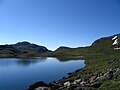 A mountain lake
 -
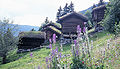
 Small farms in the community of Leveld
 -
 Mountains
 -
 Ål city center seen from Sundreberget
 -
 View of Lauvdalsbrea
 -
 Sheep are everywhere in the mountains
 -
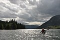 Strandafjorden, a long narrow lake in Ål kommune
 -
 Old-fashioned buildings


Famous people from Ål
Sister cities
The following cities are twinned with Ål:[10]
References
- ^ "Navn på steder og personer: Innbyggjarnamn" (in Norwegian). Språkrådet.
- ^ "Forskrift om målvedtak i kommunar og fylkeskommunar" (in Norwegian). Lovdata.no.
- ^ Bolstad, Erik; Thorsnæs, Geir, eds. (2023-01-26). "Kommunenummer". Store norske leksikon (in Norwegian). Kunnskapsforlaget.
- ^ "Kultur- og helsekommunen Ål". Ål Turistinformasjon (in Norwegian).
- ^ "Cross-country". Ål Turistinformasjon.
- ^ Knappen, Audun. "Kommunenavn i Buskerud" (in Norwegian). Terra Buskerud. Retrieved 2009-01-05.
- ^ Norske Kommunevåpen (1990). "Nye kommunevåbener i Norden". Retrieved 2009-01-05.
- ^ "Kommunevåpen" (in Norwegian). Ål kommune. Retrieved 2009-01-05.
- ^ "Immigrants and Norwegian-born to immigrant parents, by immigration category, country background and percentages of the population". ssb.no. Archived from the original on 29 July 2017. Retrieved 29 July 2017.
{{cite web}}:|archive-date=/|archive-url=timestamp mismatch; 2 July 2015 suggested (help); Unknown parameter|deadurl=ignored (|url-status=suggested) (help) - ^ "Venskap Ål-Sololá" (in Norwegian). Ål kommune. Retrieved 2009-01-05.
External links
- Municipal fact sheet from Statistics Norway
- Official Tourist Website
- Folkemusikkveka
 Buskerud travel guide from Wikivoyage
| |||||||||
 | Towns and cities | ||||||||
| Municipalities |
| ||||||||
| |||||||||