
1984 Atlantic hurricane season
| 1984 Atlantic hurricane season | |
|---|---|
 Season summary map | |
| Seasonal boundaries | |
| First system formed | June 11, 1984 |
| Last system dissipated | December 24, 1984 |
| Strongest storm | |
| Name | Diana |
| • Maximum winds | 130 mph (215 km/h) (1-minute sustained) |
| • Lowest pressure | 949 mbar (hPa; 28.02 inHg) |
| Seasonal statistics | |
| Total depressions | 18 |
| Total storms | 13 |
| Hurricanes | 5 |
| Major hurricanes (Cat. 3+) | 1 |
| Total fatalities | 35 |
| Total damage | $66.4 million (1984 USD) |
The 1984 Atlantic hurricane season was the busiest since 1971. It officially began on June 1, 1984, and lasted until November 30, 1984. These dates conventionally delimit the period of each year when most tropical cyclones form in the Atlantic basin. The 1984 season was an active one in terms of named storms, but most of them were weak and stayed at sea. Most of the cyclones tracked through the northwest subtropical Atlantic west of the 50th meridian to near the Eastern coast of the United States between mid-August and early October. The most damaging storm was Hurricane Diana, which caused $65.5 million (1984 dollars) in damage in North Carolina. Diana was the first hurricane to strike a nuclear power plant without incident; it was also the first major hurricane to strike the U.S. East Coast in nearly 20 years. Also of note was Hurricane Lili, which lasted well after the official end of the season. It was downgraded from a named storm on December 24. Damage overall from the tropical cyclones in 1984 totaled $66.4 million (1984 USD).
Season summary
Six storms during the season had subtropical characteristics at some point in their track, those being Subtropical Storm One,[1] Tropical Storm Cesar,[2] Hurricane Hortense,[3] Hurricane Josephine,[4] Hurricane Klaus,[5] and Hurricane Lili.[6]
The season's activity was reflected with a cumulative accumulated cyclone energy (ACE) rating of 84,[7] which is classified as "near normal".[8] ACE is, broadly speaking, a measure of the power of the hurricane multiplied by the length of time it existed, so storms that last a long time, as well as particularly strong hurricanes, have high ACEs. ACE is only calculated for full advisories on tropical systems at or exceeding 34 knots (39 mph, 63 km/h) or tropical storm strength. Although officially, subtropical cyclones are excluded from the total,[9] the figure above includes periods when storms were in a subtropical phase.
Systems

Tropical Depression One
| Tropical depression (SSHWS) | |
  | |
| Duration | June 11 – June 14 |
|---|---|
| Peak intensity | 35 mph (55 km/h) (1-min); ≤1016 mbar (hPa) |
By June 11, an upper level low caused thunderstorm development off the Florida coast, which caused the formation of a tropical depression. Moving westward, the depression moved into St. Augustine, causing a total of 5.02 inches (128 mm) of rainfall at Jacksonville Beach, Florida as its main thunderstorm activity was concentrated north of the center. It dissipated as a tropical cyclone on June 14 while moving through the Florida panhandle.[10][11][12] The small remnant low continued moving westward inland of the Gulf coast, causing occasional redevelopment of thunderstorm activity as the system moved into Louisiana, before both the thunderstorm activity and low pressure area dissipated by June 17.[13][14]
Tropical Depression Two
| Tropical depression (SSHWS) | |
  | |
| Duration | June 18 – June 20 |
|---|---|
| Peak intensity | 35 mph (55 km/h) (1-min); 1008 mbar (hPa) |
An upper level low moving across the southern Gulf of Mexico spawned an area of thunderstorm activity over the Mexican isthmus on June 16. The thunderstorm area moved northwest, pulsing in intensity, until flaring up into a larger area of deeper convection early in the morning of June 18. A surface low formed, and the system was considered well-enough organized to be a tropical depression, the second of the season, while located southeast of Brownsville, Texas.[15] On June 19, vertical wind shear from the west-southwest halted further development, and the tropical depression began a general weakening trend which continued past its landfall point in northeast Mexico. By early morning of June 20, the system completely dissipated.[12][16]
Tropical Depression Three
| Tropical depression (SSHWS) | |
 | |
| Duration | July 25 – July 26 |
|---|---|
| Peak intensity | 35 mph (55 km/h) (1-min); 1000 mbar (hPa) |
A tropical depression formed on July 25[17] and moved westward, producing rainfall up to six inches in Barbados on July 26.[18] The depression dissipated on July 26.[12] Two commercial fisherman were reported missing near St. Lucia.[19]
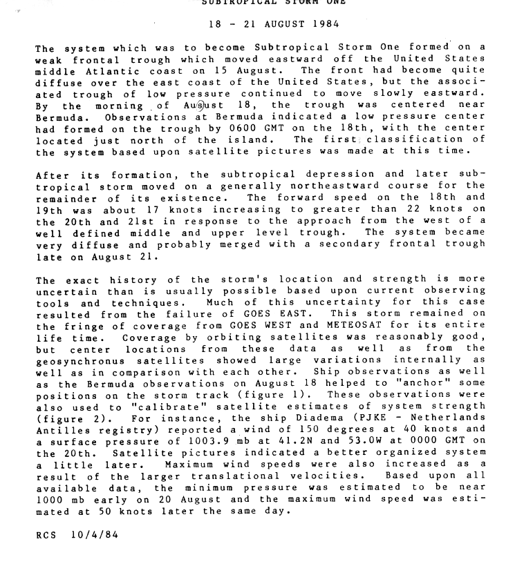
Subtropical Storm One
| Subtropical storm (SSHWS) | |
.JPG)  | |
| Duration | August 18 – August 21 |
|---|---|
| Peak intensity | 60 mph (95 km/h) (1-min); 1000 mbar (hPa) |
A weak front generated a low pressure system that organized into a subtropical depression north of Bermuda on August 18. The depression headed northeast and strengthened to a subtropical storm. It is believed to have merged with a front on August 21. The history of Subtropical Storm One is not entirely certain, as satellite images were largely unavailable due to a failure of the VISSR unit on GOES EAST (then GOES-5), and this system remained at the fringe of the GOES WEST and Meteosat throughout its existence.[20] Winds of 65 mph (100 km/h) was reported on the southwest coast of Newfoundland. In addition, a weather office on the island reported rainfall at 2.1 in (53 mm).[21]
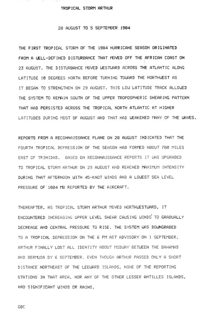
Tropical Storm Arthur
| Tropical storm (SSHWS) | |
.JPG)  | |
| Duration | August 28 – September 5 |
|---|---|
| Peak intensity | 50 mph (85 km/h) (1-min); 1004 mbar (hPa) |
The 1984 season's first named storm occurred later than usual, forming on August 28. Arthur formed east of the Windward Islands and tracked generally northwest. It was downgraded to a depression on September 1 after being negatively impacted by vertical wind shear, and dissipated several days later.[22] Arthur was a minimal tropical storm,[23] and caused no significant weather on land.
Tropical Storm Bertha
| Tropical storm (SSHWS) | |
.JPG)  | |
| Duration | August 30 – September 4 |
|---|---|
| Peak intensity | 40 mph (65 km/h) (1-min); 1007 mbar (hPa) |
Bertha was a short-lived tropical storm that formed in the mid-Atlantic on August 31, in close proximity to the east of Arthur. The storm took a parabolic path to the north and northeast before merging with a cold front on September 4. Bertha never approached land and caused no reported damage.[23]
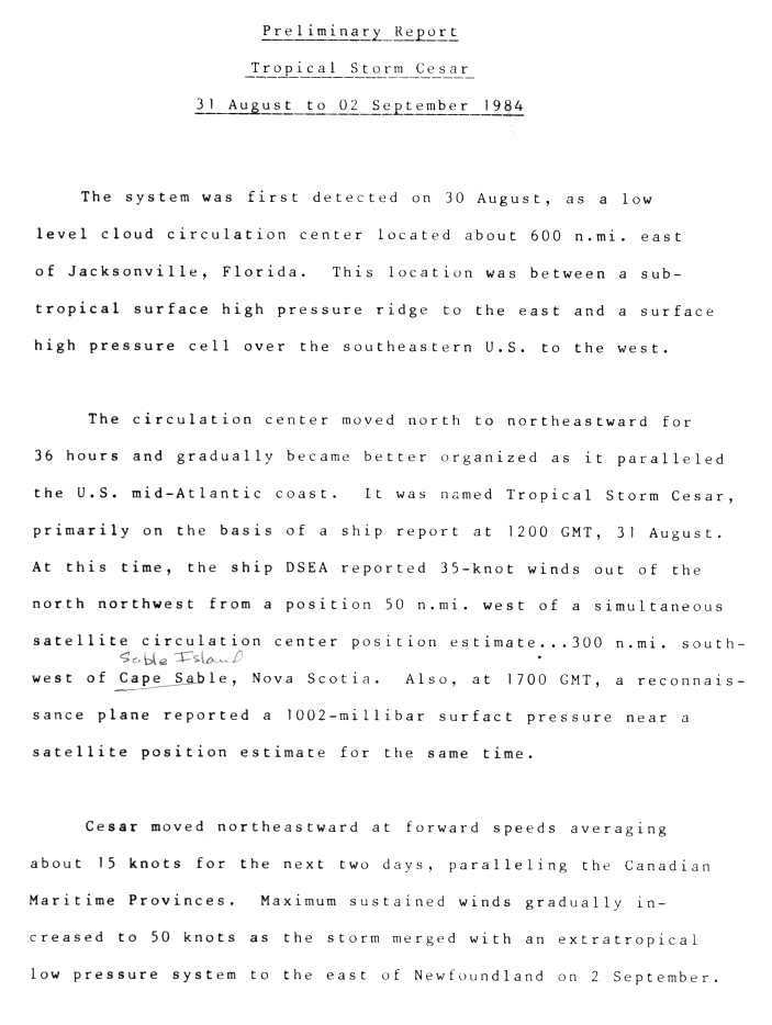
Tropical Storm Cesar
| Tropical storm (SSHWS) | |
.JPG)  | |
| Duration | August 31 – September 2 |
|---|---|
| Peak intensity | 60 mph (95 km/h) (1-min); 994 mbar (hPa) |
A second storm formed on August 31 as a non-tropical low strengthened into Tropical Storm Cesar off the East Coast of the United States. Cesar traveled east-northeast and strengthened gradually until it became extratropical and merged with another system off the coast of Newfoundland on September 2.[23]
Tropical Depression Seven
| Tropical depression (SSHWS) | |
  | |
| Duration | September 6 – September 8 |
|---|---|
| Peak intensity | 35 mph (55 km/h) (1-min); |
A tropical wave moved across Central America into the far eastern north Pacific Ocean by August 28. The system moved westward with no signs of development until September 1, when an upper level low to its north across the Gulf of Mexico caused an area of thunderstorms to form just south of the Mexican coastline. An upper trough developed across the southern Plains of the United States, which slowly lured the northern portion of this increasingly large disturbance northward through the Mexican Isthmus. The southern portion moved westward, developing into Hurricane Marie. For a short while, Marie acted as a source of vertical wind shear from the west for this system, halting further development.[24]
By September 6, the disturbance had emerged into the southwest Gulf of Mexico and consolidated into a smaller system which had enough organization to be classified as a tropical depression, the seventh of the season. The depression moved north-northwest into northeast Mexico on the afternoon of September 7, dissipating completely on September 8.[12]
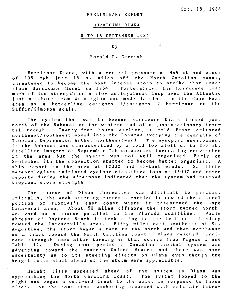
Hurricane Diana
| Category 4 hurricane (SSHWS) | |
  | |
| Duration | September 8 – September 16 |
|---|---|
| Peak intensity | 130 mph (215 km/h) (1-min); 949 mbar (hPa) |
On September 8, an extratropical cyclone organized into Tropical Storm Diana north of the Bahamas. Diana proved difficult for meteorologists to forecast, initially moving westward towards Cape Canaveral, but then turned to the north and paralleled the coastline.[25] On September 11, the storm reached hurricane strength, and continued to intensify to a Category 4 hurricane. Diana moved north-northeast, and performed a small anti-cyclonic loop before striking near Cape Fear as a minimal Category 2 hurricane on September 13. A weakened Tropical Storm Diana curved back out to sea and headed northeast until it became extratropical near Newfoundland on September 16.[23]
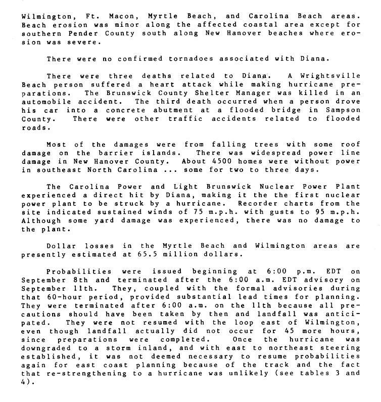
Damage estimates were set at $65.5 million. Three indirect deaths were associated with Diana. Diana was the first hurricane to strike a nuclear power plant — the Carolina Power and Light Brunswick Nuclear Power Plant recorded sustained hurricane-force winds, but there was no damage to the facility.[26]
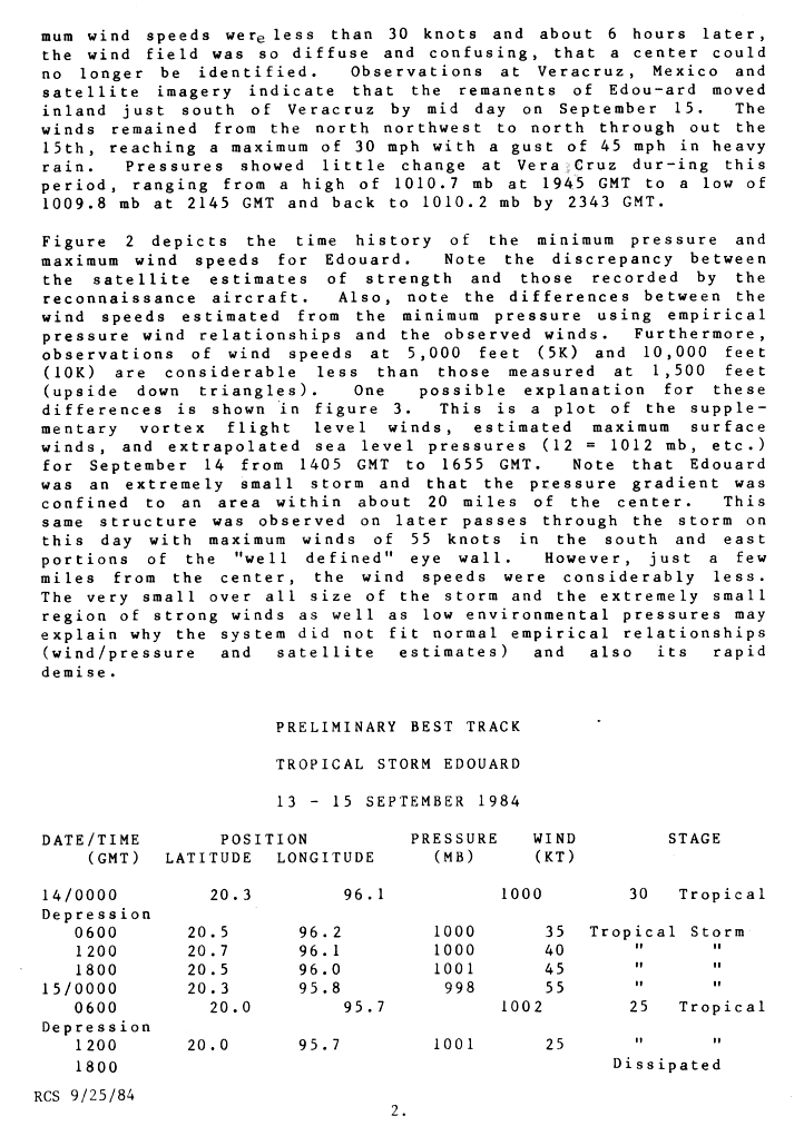
Tropical Storm Edouard
| Tropical storm (SSHWS) | |
.JPG)  | |
| Duration | September 14 – September 15 |
|---|---|
| Peak intensity | 65 mph (100 km/h) (1-min); 998 mbar (hPa) |
The origins of Tropical Storm Edouard are unclear, but an area of persistent organized storms formed in the Bay of Campeche, which strengthened into a tropical storm on September 14. Edouard rapidly intensified, with wind speeds reaching 65 mph (100 km/h) in 18 hours. Following its strengthening, Edouard dissipated even more quickly, degenerating into an area of thunderstorms the next day.[27] The remnants of Edouard moved over land near the port of Veracruz.[28]
Tropical Storm Fran
| Tropical storm (SSHWS) | |
.JPG)  | |
| Duration | September 15 – September 20 |
|---|---|
| Peak intensity | 65 mph (100 km/h) (1-min); 994 mbar (hPa) |
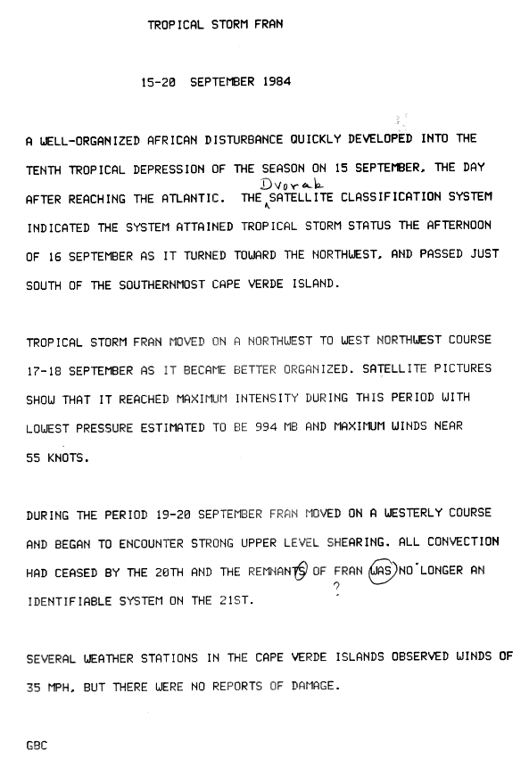
On September 14, a well-defined tropical wave exited the coast of Africa. The next day, it had rapidly organized into a tropical depression. On the afternoon of September 16 the depression attained tropical storm strength, and it was given the name Fran. It turned to the northwest, and passed very near the Cape Verde.[29] 31 people were killed in the country.[30] Fran continued between the northwest and west-northwest on September 17–18 as it continued to organize. During this period satellite imagery indicated that Fran peaked with winds of 65 mph (105 km/h) and a minimum surface pressure of 994 mbar (29.35 inHg). As Fran passed the Cape Verde islands weather stations reported 35 miles per hour (56 km/h) winds, which is tropical depression force. During the period of September 19–20 Fran turned towards westward and began to encounter strong upper level wind shear, which caused Fran to dissipate on September 20.[29]
Tropical Storm Gustav
| Tropical storm (SSHWS) | |
.JPG)  | |
| Duration | September 16 – September 19 |
|---|---|
| Peak intensity | 50 mph (85 km/h) (1-min); 1006 mbar (hPa) |
Gustav spent most of its life as a well-organized tropical depression, which formed on September 16 in the open Atlantic south of Bermuda. The depression moved north, and its motion stalled over Bermuda on September 17. A day later, the depression had strengthened to a tropical storm and was named Gustav. Tropical Storm Gustav headed northeast until it was absorbed by a front on September 19.[23]
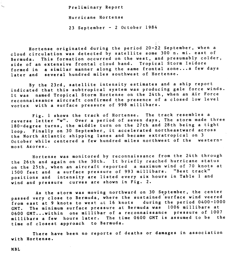
Hurricane Hortense
| Category 1 hurricane (SSHWS) | |
.JPG)  | |
| Duration | September 23 – October 2 |
|---|---|
| Peak intensity | 75 mph (120 km/h) (1-min); 993 mbar (hPa) |
A large frontal system spawned a subtropical depression early on September 23, about 385 miles (620 km) east of Bermuda. Ship and satellite data confirmed its development, and indicated the system intensified into a subtropical storm later on September 23. Initially the cyclone moved toward the south-southwest, although on September 24 it turned to the west. That day, the Hurricane Hunters reported that the system transitioned into a tropical cyclone; as such, it was named Tropical Storm Hortense. The newly-tropical storm quickly intensified while turning to the northwest, and late on September 25 Hortense attained hurricane status, about 300 miles (475 km) southeast of Bermuda.[3]
Twelve hours after reaching hurricane status, Hortense began a sharp weakening trend while passing east of Bermuda. By September 27 it was a minimal tropical storm, and subsequently it executed a clockwise loop to the southwest. The intensity of Hortense fluctuated slightly over the subsequent few days, although it never regained its former intensity. On September 30, after turning to the west and later to the north, the storm passed just 7 mi (11 km) west of Bermuda. As the storm was so weak, the island only reported winds of 18 mph (30 km/h).[3] Hortense accelerated to the northeast, moving rapidly across the north Atlantic before being absorbed by a larger extratropical storm late on October 2, northwest of the Azores.[31]
Tropical Storm Isidore
| Tropical storm (SSHWS) | |
.JPG)  | |
| Duration | September 25 – October 1 |
|---|---|
| Peak intensity | 60 mph (95 km/h) (1-min); 999 mbar (hPa) |
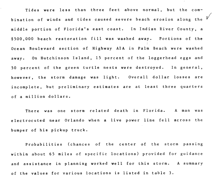
A tropical depression formed on September 25 off the southeastern Bahamas. The depression headed west, and was upgraded to a tropical storm in the central Bahamas on September 26. It struck the US coast near Jupiter, Florida. Retaining tropical storm strength, Isidore curved to the northeast, emerging over water near Jacksonville, Florida. Isidore continued northeast until it was absorbed by a front on October 1.[23] Total damages were estimated at over $750,000 (1984 US dollars). One death from electrocution was reported.[32]
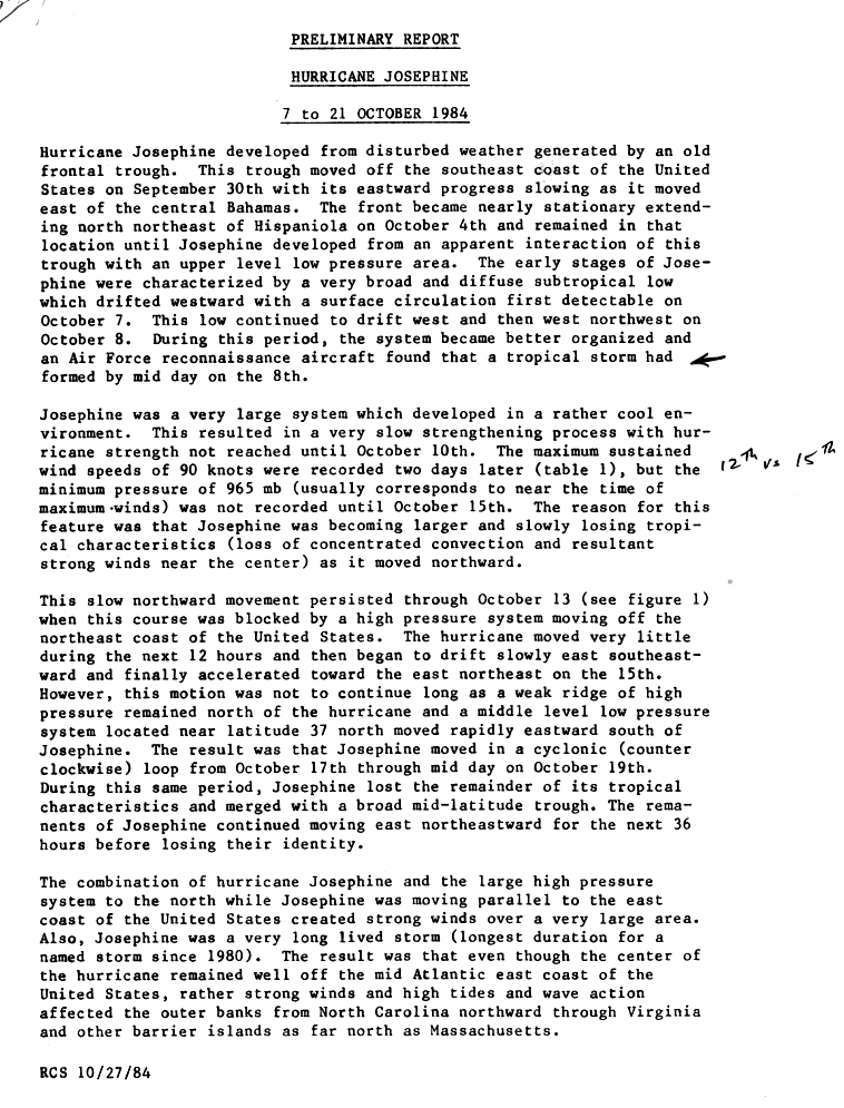
Hurricane Josephine
| Category 2 hurricane (SSHWS) | |
  | |
| Duration | October 7 – October 18 |
|---|---|
| Peak intensity | 105 mph (165 km/h) (1-min); 965 mbar (hPa) |
Josephine became a named storm on October 8 while northeast of Puerto Rico. It briefly moved west then turned almost due north. While it stayed well away from the U.S. coast, Josephine was a large storm and sustained tropical storm winds were measured at the Diamond Shoals of Cape Hatteras. When it passed 36°N latitude (roughly level with Norfolk, Virginia), Josephine curved to the southeast, then back to the northeast. It continued on this path until it made a cyclonic loop beginning on October 17 while becoming extratropical. The storm lost its identity on October 21.[23] The hurricane caused wave damage to coastal areas, but primarily posed a threat to the shipping lanes of the North Atlantic.[33]
Offshore, a sailboat with six crewmen on it became disabled due to high waves, estimated to have exceeded 15 ft (4.6 m), produced by the hurricane. All of the people on the ship were quickly rescued after issuing a distress signal by a nearby tanker vessel.[34] In Massachusetts, one man drowned after falling off his boat on North River amidst large swells produced by the storm. In Long Island, New York and parts of New Jersey, tides between 2 and 4 ft (0.61 and 1.22 m) above normal resulted in minor coastal flooding.[35]
Tropical Depression Seventeen
| Tropical depression (SSHWS) | |
  | |
| Duration | October 25 – October 28 |
|---|---|
| Peak intensity | 35 mph (55 km/h) (1-min); 1013 mbar (hPa) |
This system was recognized as the seventeenth tropical depression of the season by the National Hurricane Center after the season ended.[12] A retrograding upper-level low spurred the development of a low east of the Bahamas on October 25. The system tracked westward with limited shower and thunderstorm activity, crossing Florida on October 26 before moving into the Gulf of Mexico. Once the system moved into the north-central Gulf, deep convection began to develop near its center, expanding in intensity and coverage near and after landfall in extreme southeast Mississippi. The small system accelerated rapidly to the north and northeast ahead of an approaching cold front, moving across the Tennessee Valley and central Appalachians before linking up with the front and becoming a weak extratropical cyclone. The nontropical cyclone then moved through coastal New England.[12][36]
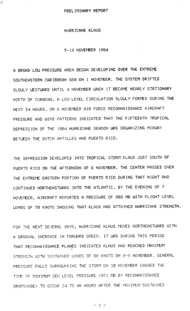
Hurricane Klaus
| Category 1 hurricane (SSHWS) | |
.JPG)  | |
| Duration | November 5 – November 13 |
|---|---|
| Peak intensity | 90 mph (150 km/h) (1-min); 971 mbar (hPa) |
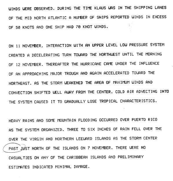
Forming from a broad area of low pressure on November 5, Klaus maintained a northeast movement throughout much of its path. After making landfall on extreme eastern Puerto Rico, it passed to the north of the Leeward Islands, resulting in strong southwesterly winds and rough seas. Klaus attained hurricane status and reached peak winds of 90 mph (145 km/h) before becoming extratropical over cooler waters on November 13.[37] The storm dropped heavy rainfall in Puerto Rico, causing minor flooding and light damage. Klaus caused heavy marine damage in the Leeward Islands, including wrecking at least three ships. The Virgin Islands experienced heavy damage, as well. Damage from the storm totaled to $152 million (1984 USD), and the hurricane killed two on Dominica.[38]
Tropical Depression Nineteen
| Tropical depression (SSHWS) | |
 | |
| Duration | November 22 – November 29 |
|---|---|
| Peak intensity | 35 mph (55 km/h) (1-min); 1005 mbar (hPa) |
A low pressure system formed east of Florida on November 22 and rode up the East Coast of the United States producing heavy rain before curving back out to sea and dissipating on November 26. The storm left one fatality and $7.4 million (1984 USD) in damage. There has been evidence that the November storm may have become a subtropical cyclone east of Bermuda. The remnants of the cyclone contributed to the Late November 1984 Nor'easter.
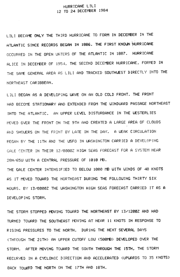
Hurricane Lili
| Category 1 hurricane (SSHWS) | |
.JPG)  | |
| Duration | December 12 – December 24 |
|---|---|
| Peak intensity | 80 mph (130 km/h) (1-min); 980 mbar (hPa) |
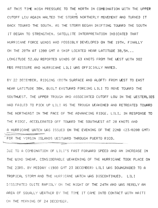
Hurricane Lili was one of only four Atlantic tropical cyclones on record to reach hurricane status in the month of December.[23][39] Lili developed as a subtropical cyclone which originated from a frontal trough to the south of Bermuda on December 12. It tracked southeastward,[40] then northward, slowly attaining tropical characteristics and becoming a hurricane on December 20. Lili turned to the south and southwest, briefly threatening the northern Caribbean islands before weakening and dissipating near the coast of the Dominican Republic. Lili was the longest lasting tropical cyclone outside of the Atlantic hurricane season, as well as the strongest hurricane to form during the month of December. It briefly threatened to pass through the Leeward Islands as a minimal hurricane, though upon passing through the area as a dissipating tropical depression Lili produced light rainfall and no reported damage.[41]
Storm names
The following names were used for named storms that formed in the north Atlantic in 1984. No names were retired, so the same list of names was used again in the 1990 season.[42] This is the first time these names were used since the post-1978 naming change, except for Bertha and Fran which were previously used in 1957 and 1973.[23] Names that were not assigned are marked in gray.
|
Retirement
The World Meteorological Organization did not retire any names used in the 1984 season.
See also
- List of Atlantic hurricanes
- List of Atlantic hurricane seasons
- 1984 Pacific hurricane season
- 1984 Pacific typhoon season
- 1984 North Indian Ocean cyclone season
- Southern Hemisphere tropical cyclone seasons: 1983–84, 1984–85
References
- ^ Sheets, Robert (October 4, 1984). "Subtropical Storm One Preliminary Report". National Hurricane Center. Retrieved October 3, 2010.
- ^ "Tropical Storm Cesar Preliminary Report". National Hurricane Center. 1984. Retrieved October 3, 2010.
- ^ a b c Lawrence, Miles (1984). "Hurricane Hortense Preliminary Report #1". National Hurricane Center. Retrieved October 3, 2010.
- ^ Sheets, Robert (October 27, 1984). "Hurricane Josephine Preliminary Report". National Hurricane Center. Retrieved October 3, 2010.
- ^ "Hurricane Klaus Preliminary Report". National Hurricane Center. 1984. Retrieved October 3, 2010.
- ^ "Hurricane Lili Preliminary Report". National Hurricane Center. c. 1985. Retrieved October 3, 2010.
- ^ Hurricane Research Division (March 2011). "Atlantic basin Comparison of Original and Revised HURDAT". National Oceanic and Atmospheric Administration. Retrieved July 23, 2011.
- ^ National Oceanic and Atmospheric Administration (May 27, 2010). "Background information: the North Atlantic Hurricane Season". Climate Prediction Center. Archived from the original on May 10, 2011. Retrieved March 30, 2011.
{{cite web}}: Unknown parameter|deadurl=ignored (|url-status=suggested) (help) - ^ David Levinson (August 20, 2008). "2005 Atlantic Ocean Tropical Cyclones". National Climatic Data Center. Retrieved July 23, 2011.
- ^ "Tropical Depression Hits Florida Coast". Philadelphia Daily News. June 13, 1984. Retrieved March 6, 2010.
- ^ "Harbinger of Hurricane Fading Fast". The Miami Herald. June 14, 1984. Retrieved March 6, 2010.
- ^ a b c d e f David M. Roth (2010). "CLIQR database". Hydrometeorological Prediction Center. Retrieved April 13, 2010.
- ^ David M. Roth (August 4, 2008). "Tropical Depression One – June 12–17, 1984". Hydrometeorological Prediction Center. Retrieved April 24, 2008.
- ^ NOAA. Daily Weather Maps: June 11–17, 1984. Retrieved on April 24, 2008.
- ^ "New Tropical Depression Forms In Gulf Of Mexico". The Miami Herald. June 19, 1984. Retrieved March 6, 2010.
- ^ David M. Roth (March 8, 2010). "Tropical Depression Two — June 16–20, 1984". Hydrometeorological Prediction Center. Retrieved March 8, 2010.
- ^ "Potential Tropical Storm Monitored". The Miami Herald. July 25, 1984. Retrieved March 6, 2010.
- ^ "Tropical Depression Hits Caribbean". The Miami Herald. July 26, 1984. Retrieved March 6, 2010.
- ^ "Storm Weakens In Caribbean Two Fishermen Missing After Ignoring Warnings". The Miami Herald. July 28, 1984. Retrieved March 6, 2010.
- ^ National Hurricane Center (1984). "Subtropical Storm One: 18–21 August 1984". National Oceanic and Atmospheric Administration. Retrieved February 17, 2010.
- ^ "1984-Subtrop 1". Environment Canada. September 14, 2010. Retrieved July 10, 2011.
- ^ Gilbert Clark (1984). "Tropical Storm Arthur: 28 August to 5 September 1984". National Hurricane Center. Retrieved April 13, 2010.
- ^ a b c d e f g h i "Atlantic hurricane best track (HURDAT version 2)" (Database). United States National Hurricane Center. April 5, 2023. Retrieved May 6, 2024.
 This article incorporates text from this source, which is in the public domain.
- ^ David M. Roth (March 9, 2010). "Tropical Depression Seven — September 1–8, 1984". Hydrometeorological Prediction Center. Retrieved March 9, 2010.
- ^ Harold P. Gerrish (October 18, 1984). "Preliminary Report: Hurricane Diana". National Hurricane Center. p. 1. Retrieved December 9, 2008.
- ^ Harold P. Gerrish (October 18, 1984). "Preliminary Report: Hurricane Diana". National Hurricane Center. p. 3. Retrieved December 9, 2008.
- ^ "Preliminary Report: Tropical Storm Edouard – 13 to 15 September 1984". National Hurricane Center. 1984. p. 1. Retrieved March 6, 2010.
- ^ "Preliminary Report: Tropical Storm Edouard – 13 to 15 September 1984". National Hurricane Center. 1984. p. 2. Retrieved March 6, 2010.
- ^ a b "Nation Hurricane Center Report". National Hurricane Center. Retrieved September 18, 2010.
- ^ "The Deadliest Atlantic Tropical Cyclones". National Hurricane Center. Retrieved September 19, 2010.
- ^ Miles B. Lawrence and Gilbert B. Clark (July 1985). "Atlantic Hurricane Season of 1984" (PDF). Monthly Weather Review. 113. National Oceanic and Atmospheric Administration: 1228–1237. Bibcode:1985MWRv..113.1228L. doi:10.1175/1520-0493(1985)113<1228:ahso>2.0.co;2. Archived from the original (PDF) on December 7, 2010. Retrieved December 11, 2010.
{{cite journal}}: Unknown parameter|deadurl=ignored (|url-status=suggested) (help) - ^ Harrold P. Gerrish (October 29, 1984). "Preliminary Report: Tropical Storm Isidore – 25 September to 1 October 1984". National Hurricane Center. p. 4. Retrieved March 6, 2010.
- ^ Robert Sheets (October 27, 1984). "Preliminary Report: Hurricane Josephine – 7 to 21 October 1984". National Hurricane Center. Retrieved March 6, 2010.
- ^ Associated Press (October 11, 1984). "Hurricane Josephine scaring mariners now". The Day. Retrieved January 22, 2010.
- ^ Associated Press (October 15, 1984). "Hurricane Josephine moves away from land". The Free Lance-Star. Retrieved January 25, 2010.
- ^ David M. Roth (May 11, 2008). "Tropical Depression: October 25–29, 1984". Hydrometeorological Prediction Center. Archived from the original on October 5, 2008. Retrieved November 13, 2008.
{{cite web}}: Unknown parameter|deadurl=ignored (|url-status=suggested) (help) - ^ "Hurricane Klaus Preliminary Report Page One". National Hurricane Center. 1984. Retrieved April 13, 2010.
- ^ "Hurricane Klaus Preliminary Report Page Two". National Hurricane Center. 1984. Retrieved October 21, 2006.
- ^ National Hurricane Center (2006). "Tropical Cyclone Report: Hurricane Epsilon" (PDF). National Oceanic and Atmospheric Administration. Retrieved February 14, 2006.
- ^ "Hurricane Lili Preliminary Report Page 1". National Hurricane Center. 1984. Retrieved April 13, 2010.
- ^ "Hurricane Lili Preliminary Report Page 2". National Hurricane Center. 1984. Retrieved March 31, 2007.
- ^ National Hurricane Center (2009). "Retired Hurricane Names Since 1954". National Oceanic and Atmospheric Administration. Retrieved September 13, 2009.
External links
Tropical cyclones of the 1984 Atlantic hurricane season | ||
|---|---|---|
| ||