
Abel Tasman National Park
This article needs additional citations for verification. (March 2007) |
| Abel Tasman National Park | |
|---|---|
| Location | Tasman District, New Zealand |
| Nearest city | Motueka |
| Area | 225 km² |
| Established | 1942 |
| Governing body | Department of Conservation |
The Abel Tasman National Park is a national park located at the north end of the South Island of New Zealand. The park was founded in 1942 and with a coverage of only 225 km², is the smallest of New Zealand's national parks. The park consists of forested, hilly country to the north of the valleys of the Takaka and Riwaka Rivers, and is bounded to the north by the waters of Golden Bay and Tasman Bay. It is named after Abel Tasman, who in 1642 became the first European explorer to sight New Zealand.
Abel Tasman National Park does not extend beyond Mean High Water Mark on the adjacent coast. Between Mean High Water and Mean Low Water Springs, the beaches are gazetted as a Scenic Reserve, covering 774 hectares in total (about 70 kms long).
Department of Conservation administers the National Park. The Scenic Reserve is administered by the Tasman District Council (TDC) Chief Executive and Department of Conservation’s Nelson/ Marlborough Conservator. Activities in adjoining coastal waters are TDC’s responsibility. These areas operate under separate regulations.
The Abel Tasman Coast Track is a popular tramping track which follows the coastline; while an inland route, the Abel Tasman Inland Track, is less frequented. Kayaking, camping and sightseeing are other activities carried out in the park.
The nearest large town is Motueka, 20 kilometres to the south.
-

-
 Totaranui
 -
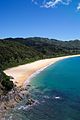
 One of many beaches along the Abel Tasman Coast Track
 -


See also
External links
- Department of Conservation information on Abel Tasman National Park
- Guided Walk Abel Tasman Coastal Track
- Sea Kayak Abel Tasman Coastal Track
This Tasman District geography article is a stub. You can help Wikipedia by expanding it. |
This protected areas-related article is a stub. You can help Wikipedia by expanding it. |