
Ararat Province
Ararat
Արարատ | |
|---|---|
.svg) Location of Ararat within Armenia | |
| Coordinates: 39°55′N 44°43′E / 39.917°N 44.717°E | |
| Country | Armenia |
| Capital and largest city | Artashat |
| Government | |
| • Governor | Aramayis Grigoryan |
| Area | |
| • Total | 2,090 km2 (810 sq mi) |
| • Rank | 9th |
| Population (2011) | |
| • Total | 260,367[1] |
| • Rank | 3rd |
| Time zone | AMT (UTC+04) |
| Postal code | 0601-0823 |
| ISO 3166 code | AM.AR |
| FIPS 10-4 | AM02 |
| Website | Official website |
Ararat (Armenian: Արարատ, Armenian pronunciation: [ɑɾɑˈɾɑt] ⓘ), is a province (marz) of Armenia. Its capital and largest city is the town of Artashat.
The province is named after the biblical Mount Ararat. It is bordered by Turkey from the west and Azerbaijan's Nakhchivan Autonomous Republic from the south. It surrounds the Karki exclave of Nakhichevan which has been controlled by Armenia since its capture in May 1992 during the Nagorno-Karabakh War. Domestically, Ararat is bordered by Armavir Province from the northwest, Kotayk Province from the north, Gegharkunik Province from the east, Vayots Dzor Province from the southeast and the city of Yerevan from the north.
Two former capitals of Armenia are located in the modern-day Ararat Province, Artaxata and Dvin. It is also home to the Khor Virap monastery, significant as the place of Gregory the Illuminator's 13-year imprisonment and the closest point to Mount Ararat within Armenian borders.
Etymology
| Part of a series on |
| Armenia Հայաստան |
|---|
  |
| Culture |
| History |
| Demographics |
| Administrative divisions |
|
Ararat Province is named after the historic Ayrarat province of Ancient Armenia.
According to Movses Khorenatsi and the Ashkharatsuyts medieval Armenian geographical book of Anania Shirakatsi, Ayrarat was one of the 15 provinces of Armenia Major. It was considered the central province of the Armenian Highland.
Most probably, the term Ararat (Armenian: Արարատ) derives from the Hebrew name of the ancient kingdom of Urartu.[2]
Geography
.jpg)
Ararat has an area of 2,090 km² (7% of total area of Armenia). It occupies the east of the central part of modern-day Armenia. From the north, it has borders with Armavir Province, Yerevan and Kotayk Province. From the east, its bordered by Gegharkunik and Vayots Dzor. Iğdır Province of Turkey and Azerbaijan's Nakhchivan Autonomous Republic respectively form the western and southern borders of the province.
Historically, the current territory of the province mainly occupies the Vostan Hayots canton of Ayrarat province of Ancient Armenia.

The province is located at the southeast of the Ararat plain, surrounded by the Yeranos mountains from the north, the mountains of Gegham, Dahnak and Mzhkatar from the east, Urts mountains from the south and the Araks river from the west. The mountains of Yerakh are located at the centre of the province. Approximately, 30% of the territory is plain, while the rest is dominated by mountains.
The highest point of Ararat province is the Spitakasar peak of Gegham mountains with a height of 3560 meters. The lowest point is 801 meters at the Araks valley.
Araks, Hrazdan, Azat and Vedi, are the 4 major rivers the flow through the province.
The climate is highly diversified in the province. It ranges between extremely arid climate at the lower plains and cold snowy climate at the heights.
History

The region of modern-day Ararat Province is among the earliest locations that was settled by the people of the Armenian Highland. It mainly includes the 3 cantons of Vostan Hayots, Urstadzor and Arats of the historic Ayrarat province. Vostan Hayots was known since the establishment of the Artaxiad Kingdom of Armenia at the beginning of the 2nd century BC. The ancient Armenian capitals of Artaxata founded in 176 BC, and Dvin founded during the 4th century AD, were both located within the Vostan Hayots canton. The other cantons of Urtsadzor and Arats were first mentioned in the 5th century AD by Yeghishe the historian in his "History of Vardan and the Armenian War" historical work.
After the fall of the Armenian Kingdom in 428, the region became part of the Sasanian Empire of Persia until the Arab conquest of Armenia in the mid-7th century. According to the 8th-century historian Ghevond, the Armenian princes of Urtsadzor canton participated in the failed revolution of 775 in Erciş against the Abbasid rulers of Arminiya.

At the end of the 9th century, the 3 cantons became part of the newly established Bagratid Kingdom of Armenia. However, between the 11th and 15th centuries, the region suffered from the Seljuk, Mongol, Ag Qoyunlu and Kara Koyunlu invasions, respectively. At the beginning of the 16th century, the territory of modern-day Ararat became part of the Erivan Beglarbegi within the Safavid Persia. During the first half of the 18th century, the territory became part of the Erivan Khanate under the rule of the Afsharid dynasty and later under the Qajar dynasty of Persia. It remained under the Persian rule until 1827-1828, when Eastern Armenia was ceded by the Russian Empire as a result of the Russo-Persian War of 1826–28 and the signing of the Treaty of Turkmenchay. With the fall of the Russian Empire and as a result of the decisive Armenian victories over the Turks in the battles of Sardarabad, Abaran, and Gharakilisa, the region became part of the independent Armenia in May 1918.
After 2 years of brief independence, Armenia became part of the Soviet Union in December 1920. From 1930 until 1995, modern-day Ararat was divided into 3 raions within the Armenian SSR: Masis raion, Artashat raion, and Ararat raion (known as Vedi raion until 1968). With the territorial administration reform of 1995, the 3 raions were merged to form the Ararat Province.
Demographics
Population

According to the 2011 official census, Shirak has a population of 260,367 (74,103 men and 133,146 women), forming around 8.6% of the entire population of Armenia. The urban population is 74,103 (28.46%) and the rural is 186,264 (71.54%). The province has 4 urban and 93 rural communities. The largest urban community is the provincial centre of Artashat, with a population of 22,269. The other urban centres are Ararat, Masis and Vedi.
With a population of 8,376, the village of Ayntap is the largest rural municipality of Ararat.
Ethnic groups and religion
The majority of the Ararat Province population are ethnic Armenians who belong to the Armenian Apostolic Church. The regulating body of the church is the Araratian Pontifical Diocese, headed by Archbishop Navasard Kchoyan (seat in Yerevan).
However, the village of Verin Dvin is predominantly populated by Assyrians belonging to the Assyrian Church of the East, whose ancestors migrated to Armenia from Iran during the 1st half of the 19th century. Almost half of the population of the village of Dimitrov is also Assyrian. The provincial centre Artashat is also home to a small Assyrian community. The approximate number of the Assyrians in Ararat Province is around 2,500.
Culture


There are cultural palaces as well as public libraries in the towns of Ararat, Artashat, Masis and Vedi. The provincial centre Artashat is also home to the Amo Kharazyan drama theatre.
The province has many art academies, sport schools and musical schools, mainly in the urban settlements.
The House-museum of Vazgen Sargsyan is operating in the village of Ararat (village), Armenia since 2001.
Fortresses and archaeological sites
- Ancient Artashat archaeological site,
- Ancient Dvin archaeological site,
- Kakavaberd fortress of the 4th century,
- Tapi Fortress of the 10th century,
- Mausoleum of Kara Koyunlu emirs in Argavand, built in 1413.
Churches and monasteries
- Aghjots Vank monastery of the 13th century,
- Hovhannes Karapaet Monastery near Shaghap, from the 13th century,
- Khor Virap monastery of the 17th century.
Transportation
The M-2 Motorway that connects the capital Yerevan with southern Armenia and the Iranian border, passes through the Ararat Province.
The towns of Artashat and Ararat used to have a railway station that connected Yerevan with the Nakhchivan Autonomous Republic during the Soviet years.
Economy
Agriculture

.jpg)
Being located at the fertile Ararat plain, the province contributes with 15% in the annual total agricultural product of Armenia.[3] Around 75% (1,567 km²) of the total area of the province are arable lands, out of which 17.23% (270 km²) are ploughed.[4]
Orchards mainly produce grapes, apricot and peach. and apple. Other products include pear, apple, melon, watermelon and eggplant. Grains and dry seed are also among the crops of the agricultural activities in Ararat.
The irrigation infrastructure of the province is quite developed. 90% of the farmlands are irrigated, mainly using canals opened from the rivers of Vedi and Azat.
The Geghanist village has a specialized plant in producing fertilizers and irrigation system design.
The province has 2 large poultry farms in the village of Kaghtsrashen and the town of Masis.
Recently, fish farming has significantly developed in the province. The largest fish farming ponds are located at the vicinity of Armash village.
Industry
Ararat is among the most industrialized provinces of Armenia with many large industrial firms. It currently has a contribution of 10% in the annual total industrial product of Armenia.

- Production of alcoholic drinks is among the leading sectors in Ararat with a large number of factories spread all over the communities of the province. Major producers of the province include:
- Aregak Brandy Factory, founded in 1889 in Dalar (privatized in 1992).
- Ararat Wine Factory, founded in 1903 in Ararat village.
- Artashat Vincon Winery, founded in 1905 in Mkhchyan (privatized in 1995).
- Ararat Cognac Factory AKZ for brandy and wine, opened in 1932 in Avshar.
- Aygezard Wine Factory, founded in 1936 in Aygepat.
- Vedi Alco Winery for wine, brandy and vodka, founded in 1956 in Ginevet (privatized in 1994).
- Avshar Wine Factory for wine, brandy and vodka, founded in 1968 in Avshar (privatized in 1995).
- Yeraskh Wine Factory, founded in 1970 in Yeraskh.
- Van 777 Winery for wine and brandy, founded in 1992 in Taperakan.
- Agatat-Gold Winery for wine, brandy and vodka, founded in 2007 in Nor Kyurin.
- Shato Arno Winery for wine and brandy, founded in 2002 in Ayntap.
- Tavinko Winery for wine and brandy, founded in 2006 in Taperakan.
- Mrganush Brandy Factory for vodka and brandy, opened in 2002 in Mrganush
- Shaumyan-Vin Winery (wine, brandy, vodka), opened in 2006 in Shahumyan.
- Shaumyan Alco for brandy and vodka, opened in 2007 in Artashat.
- Abrikon Distillery for apricot vodka, opened in 2010 in Ararat village.
- "Proshyan Brandy Factory-Aygestan Branch", in Aygestan.
- Preserved food production is also developed in the province. The "Artfood" Artashat Cannery (since 1961), the "Araratyan LLC" for dairy products in Kaghtsrashen, the "Lula LLC" for dairy products in Dalar, and the "Armenian Dried Fruits" plant of Surenavan (since 2007) are the leading firms in this sector.
- The town of Masis has an industrial hub that is home to many large firms. The town is a major centre for tobacco products in Armenia with its two factories: the "Masis Tobacco" company (SINCE 1999) and the "International Masis Tabak" company (since 2002). Other industries of Masis include the "ElektraMachTrade" factory for industrial equipments (since 1979), the "Grand-Master" factory for heavy-duty papers (since 1995), the "Masis Garun" clothing factory (since 1995), the "Berma" plant for asphalt concrete (since 1997), and the "Medical Horizon" factory for drugs and pharmaceuticals (since 2005).

- The town of Ararat is home to the "Ararat Cement" factory and the "Geopromining Gold" recovery plant. However, there is a major controversy over the pollution and the toxic waste caused by the various enterprises based on the manufacturing of building materials and the gold processing facility in the town of Ararat. The Ararat Gold Recovery extracts gold from the raw ore sent from the gold mine in Sotk located 20 kilometres (12 miles) east of Lake Sevan.[5] About 0.46 grams of gold is extracted from each ton of sand unearthed at the mines. The extraction process involves first pulverizing the raw material, and then filtering out the gold using a cyanide nitrate chemical process.[5] The soupy byproduct of the cyanide nitrate chemical process is both toxic and radioactive and collects in a tailing dam. There have been numerous incidents of animals dying near and around the plant's area.[5] Also, within the years 2003 and 2008, there have been at least 10 accidents at the plant, some of which have resulted in the discharge of the cyanide soup into neighboring agricultural lands and fisheries, killing off cows and fish stock.[5]
- Other major firms in the province include the "AraratShin" construction company and building materials producers in Ararat (since 1984), the "Manana Stone" plant for building materials in Surenavan (since 1995), the "Vedi Plast" plastic products plant (since 1998) in Vedi, the "Zovashen" company for electrical power plants in Lanjazat (since 2001), the "Abit" Armenian-Russian asphalt factory (since 2009) in Surenavan, the "Izipanel" sandwich panels manufacturing plant in Artashat (since 2012), the "Ararat Group" mineral water factory in Artashat (since 2012), the "Kavashen" plant for building materials in Ararat, and the "Travertine" stone-processing plant in Vedi.
Tourism
.JPG)
The Khor Virap monastery is among the regular tourist destinations in Ararat Province. The ancient settlements of Artaxata and Dvin are among the attractive sites for archaeologists.
The province is home to many protected areas of nature including the Khosrov Forest State Reserve, the Goravan Sands Sanctuary and the Khor Virap Wildlife Sanctuary.
Education
As of the 2015-16 educational year, Ararat Province has 112 schools,[6] out of which 107 are operated by the province administration, while 5 are under the direct supervision of the Ministry of Education and Science. As of the end of 2015, the number of the students in the schools of the province is 31,457.[7]
There are many public libraries and cultural houses in the towns of Artashat, Ararat, Masis and Vedi.
However, there are no higher education institutions in the province.
Sport

Araks Ararat founded in 1960 had represented the province in domestic and international football competitions. However, the club was and dissolved in 2001 due to financial difficulties.
At the end of 2001, another football club with the name of FC Araks was founded in Ararat, but lasted only 4 years before being dissolved.
FC Dvin Artashat founded in 1982, was also a prominent football club in the province. The remained in professional football until 1999, before being dissolved like most Armenian football clubs outside the capital Yerevan.
Masis FC played in the domestic completions between 1992 and 1994 when they were also dissolved.
There ae 2 stadiums in the province: the Ayg Stadium of Ararat and the Artashat City Stadium. The latter is the regular home of the annual National Athletics Championship of Armenia.
Communities and settlements

Ararat is home to the following 97 administrative communities (hamaynkner), of which 4 are urban and 93 are rural.[8] The administration of the province is headquartered in Artashat.
Urban communities
| Image | City (town) | Other included settlements |
Founded | Land area (km2) | Population (2011 census) |
Population (2016 estimate) |
|---|---|---|---|---|---|---|
 |
Ararat | 1930 | 6 | 20,235 | 20,300 | |
 |
Artashat | 1945 | 12 | 22,269 | 20,700 | |
 |
Masis | 1953 | 5.7 | 20,215 | 20,500 | |
 |
Vedi | 13th century (first mentioned) | 5.6 | 11,384 | 11,600 |
Rural communities and included settlements
- Abovyan
- Agamzalu
- Araksavan
- Aralez
- Ararat
- Arbat
- Arevabuyr
- Argavand
- Arevshat
- Armash
- Avshar
- Aygepat
- Aygestan
- Aygavan
- Aygezard
- Ayntap
- Azatashen
- Azatavan
- Azizkend
- Baghramyan
- Bardzrashen
- Berdik
- Berkanush
- Burastan
- Byuravan
- Dalar
- Darakert
- Darbnik
- Dashtakar
- Dashtavan
- Deghdzut
- Dimitrov
- Ditak
- Dvin
- Geghanist
- Getapnya
- Getazat
- Ghukasavan
- Ginevet
- Goravan
- Hayanist
- Hnaberd
- Hovtashat
- Hovtashen
- Jrahovit
- Jrashen
- Kaghtsrashen
- Kanachut
- Khachpar
- Lanjanist
- Lanjar
- Lanjazat
- Lusarat
- Lusashogh
- Marmarashen
- Masis
- Mkhchyan
- Mrganush
- Mrgavan
- Mrgavet
- Narek
- Nizami
- Nor Kharberd
- Nor Kyank
- Nor Kyurin
- Nor Ughi
- Norabats
- Noramarg
- Norashen
- Noyakert
- Nshavan
- Paruyr Sevak
- Pokr Vedi
- Ranchpar
- Sayat-Nova
- Shaghap
- Shahumyan
- Sipanik
- Sis
- Sisavan
- Surenavan
- Taperakan
- Urtsadzor
- Urtsalanj
- Vanashen
- Vardashat
- Vardashen
- Verin Artashat
- Verin Dvin
- Vosketap
- Vostan
- Yeghegnavan
- Yeraskh
- Zangakatun
- Zorak
Abandoned settlements
Gallery
- Ararat
-
 Capital of Saint Gregory Cathedral, ancient Dvin
 -
 The remains of Aghjots Vank monastery
 -
 Mount Kotuts of the Urts mountain range at the centre of the province
 -

-
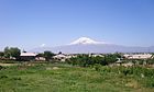 Ararat from Nor Kyurin village


See also
References
- ^ Ararat population, 2011 census
- ^ "Ararat". Jewish Virtual Library. 2008. Retrieved 27 July 2009.
- ^ Armstat: Ararat
- ^ Ararat Province: general information
- ^ a b c d Behind Gold's Luster Lie Lands Torn Asunder and Urgent Questions, Hetq Online, May 19, 2008.
- ^ Ararat Province schools
- ^ School conditions in Ararat Province
- ^ "RA Ararat Marz" (PDF). Marzes of the Republic of Armenia in Figures, 2002–2006. National Statistical Service of the Republic of Armenia. 2007.

| Provinces (մարզեր) | ||
|---|---|---|
| City with special status |
| |