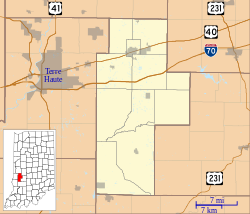
Buchanan Corner, Indiana
An editor has nominated this article for deletion. You are welcome to participate in the deletion discussion, which will decide whether or not to retain it. |
Buchanan Corner | |
|---|---|
| Coordinates: 39°11′33″N 87°12′12″W / 39.19250°N 87.20333°W | |
| Country | United States |
| State | Indiana |
| County | Clay |
| Township | Lewis |
| Elevation | 584 ft (178 m) |
| GNIS feature ID | 431708[1] |
Buchanan Corner is a place in Lewis Township, Clay County, Indiana, United States.[2][3][4]
History[edit]
Schoolhouses[edit]
The first school house in Buchanan District was built on the northwest corner of the Edward Braden farm, konown c. 1916 as the Ira Bare place.[3] After the original schoolhouse was abandoned, a new one was built in the southwest corner of what was c. 1916 known as the "old Eagon place." and last used for school in 1851.[3] A new school house was built three-eighths of a mile south of the second building and replaced by a brick structure in 1896, and was in use c. 1916.[3]
References[edit]
- ^ "Buchanan Corner, Indiana". Geographic Names Information System. United States Geological Survey, United States Department of the Interior. Retrieved October 10, 2009.
- ^ "Buchanan Corner, IN". topoquest.com. Retrieved May 9, 2024.
- ^ a b c d History of Lewis Township, Clay County, Indiana. Brazil News-Democrat. 1916.
- ^ Survey (U.S.), Geological (1988). The National Gazetteer of the United States of America--Indiana, 1988. U.S. Government Printing Office.


