
File:EnglandWiltshire.svg

Size of this PNG preview of this SVG file: 200 × 247 pixels. Other resolutions: 194 × 240 pixels | 389 × 480 pixels | 622 × 768 pixels | 829 × 1,024 pixels | 1,658 × 2,048 pixels.
Original file (SVG file, nominally 200 × 247 pixels, file size: 232 KB)
| This is a file from the Wikimedia Commons. Information from its description page there is shown below. Commons is a freely licensed media file repository. You can help. |
Summary
| Description |
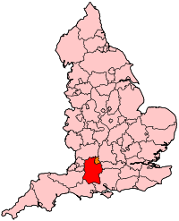
English: Map of Wiltshire within England. |
| Source | Own work |
| Author | Wereon |
Licensing
| I, the copyright holder of this work, release this work into the public domain. This applies worldwide. In some countries this may not be legally possible; if so: I grant anyone the right to use this work for any purpose, without any conditions, unless such conditions are required by law. |
File history
Click on a date/time to view the file as it appeared at that time.
| Date/Time | Thumbnail | Dimensions | User | Comment | |
|---|---|---|---|---|---|
| current | 20:50, 22 April 2007 | | 200 × 247 (232 KB) | Wereon | Map of Wiltshire within England. Category:Maps of counties of England |
File usage
The following pages on the English Wikipedia use this file (pages on other projects are not listed):
- 2009 structural changes to local government in England
- Chippenham (UK Parliament constituency)
- Devizes (UK Parliament constituency)
- North Swindon (UK Parliament constituency)
- North Wiltshire (UK Parliament constituency)
- Parliamentary constituencies in South West England
- Salisbury (UK Parliament constituency)
- South Swindon (UK Parliament constituency)
- South West Wiltshire (UK Parliament constituency)
- Westbury (UK Parliament constituency)
Global file usage
The following other wikis use this file:
- Usage on ar.wikipedia.org
- Usage on cy.wikipedia.org
- Usage on fr.wikipedia.org
- Usage on oc.wikipedia.org
- Usage on pl.wikipedia.org
- Usage on simple.wikipedia.org
- Usage on www.wikidata.org
- Usage on zh.wikipedia.org