Guihulngan: Difference between revisions
| Line 75: | Line 75: | ||
[[vi:Guihulngan]] |
[[vi:Guihulngan]] |
||
[[war:Syudad han Guihulngan]] |
[[war:Syudad han Guihulngan]] |
||
its me lanz galanza.. hehehe.. was in guihulngan after fiesta to visit my family. every year i see a lot of changes..i visit guihulngan every year though. |
|||
Revision as of 13:39, 17 July 2009

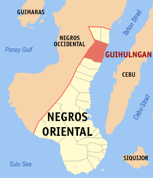
Guihulngan is a municipality in the province of Negros Oriental, Philippines. According to the 2000 census, it has a population of 83,448 people in 17,733 households.
Barangays
Guihulngan is politically subdivided into 33 barangays.
|
|
|
Nullification of cityhood
Recently Guihulngan lost its cityhood, along with 15 other cities, after the Supreme Court of the Philippines granted a petition filed by the League of Cities of the Philippines, and declared the cityhood law (RA 9409) which allowed the town to acquire its city status, unconstitutional. The said cities, the court ruled, did not meet the requirements for cityhood. ah ok...baby boy ni..
External links
- Philippine Standard Geographic Code
- Guihulngan Official Website
- Guihulngan eCommunity - Connecting Guihulnganons Online
- REACT NEGOR in Guihulngan
10°07′N 123°16′E / 10.117°N 123.267°E
its me lanz galanza.. hehehe.. was in guihulngan after fiesta to visit my family. every year i see a lot of changes..i visit guihulngan every year though.
