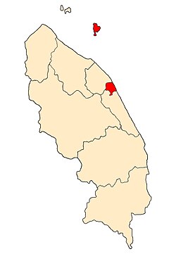
Kuala Terengganu District
Appearance
Kuala Terengganu District | |
|---|---|
| Daerah Kuala Terengganu | |
| Other transcription(s) | |
| • Jawi | كوالا ترڠڬانو |
| • Chinese | 瓜拉登嘉楼县 |
 Location of Kuala Terengganu District in Terengganu | |
 | |
Location of Kuala Terengganu District in Malaysia | |
| Coordinates: 5°20′N 103°10′E / 5.333°N 103.167°E | |
| Country | |
| State | |
| Seat | Kuala Terengganu |
| Local area government(s) | Kuala Terengganu City Council |
| Government | |
| • District officer | Azmi Razik |
| Area | |
• Total | 210.21 km2 (81.16 sq mi) |
| Population | |
• Total | 343,284 |
• Estimate (2014)[3] | 184,600 |
| • Density | 1,600/km2 (4,200/sq mi) |
| Time zone | UTC+8 (MST) |
| • Summer (DST) | UTC+8 (Not observed) |
| Postcode | 21xxx |
| Calling code | +6-09-6 |
| Vehicle registration plates | T |
The Kuala Terengganu District is a district in the state of Terengganu, Malaysia. It covers an area of 210.21 square kilometres, and had a population of 343,284 at the 2010 Census .[2] The district is bordered by Terengganu River which separates Kuala Nerus District in the north and west, Marang District in the south and South China Sea in the east. The capital of this district is Kuala Terengganu.
Administrative divisions

Kuala Terengganu District is divided into 20 mukims/sub-districts, which are:
- Atas Tol
- Bandar
- Batu Buruk
- Belara
- Bukit Besar
- Cabang Tiga
- Cenering
- Gelugur Kedai
- Gelugur Raja
- Kepung
- Kuala Ibai
- Kubang Parit
- Losong
- Manir
- Paluh
- Pengadang Buluh
- Pulau-pulau
- Rengas
- Serada
- Tok Jamal
Demographics
| Year | Pop. | ±% | ||
|---|---|---|---|---|
| 1991 | 274,489 | — | ||
| 2000 | 298,304 | +8.7% | ||
| 2010 | 337,553 | +13.2% | ||
| 2020 | 229,780 | −31.9% | ||
| ||||
| Figures before 2014 includes Kuala Nerus District. Source: [4] | ||||
Federal Parliament and State Assembly Seats
List of Kuala Terengganu district representatives in the Federal Parliament (Dewan Rakyat)
| Parliament | Seat Name | Member of Parliament | Party |
|---|---|---|---|
| P36 | Kuala Terengganu | Ahmad Amzad Hashim | PN (PAS) |
List of Kuala Terengganu district representatives in the State Legislative Assembly of Terengganu
| Parliament | State | Seat Name | State Assemblyman | Party |
|---|---|---|---|---|
| P36 | N13 | Wakaf Mempelam | Wan Sukairi Wan Abdullah | PN (PAS) |
| P36 | N14 | Bandar | Ahmad Shah Muhamed | PN (PAS) |
| P36 | N15 | Ladang | Tengku Hassan Tengku Omar | PN (PAS) |
| P36 | N16 | Batu Buruk | Muhammad Khalil Abdul Hadi | PN (PAS) |
See also
References
Wikimedia Commons has media related to Kuala Terengganu.
- ^ Administrator. "Laman Web Rasmi Pejabat Daerah Dan Tanah Kuala Nerus". pdtknerus.terengganu.gov.my.
- ^ a b "Population Distribution and Basic Demographic Characteristics, 2010" (PDF). Department of Statistics, Malaysia. Archived from the original (PDF) on 22 May 2014. Retrieved 19 April 2012.
- ^ Administrator. "Pengenalan Daerah Dungun". pdtdungun.terengganu.gov.my.
- ^ "Key Findings of Population and Housing Census of Malaysia 2020" (pdf) (in Malay and English). Department of Statistics, Malaysia. ISBN 978-967-2000-85-3.


