From Wikipedia, the free encyclopedia
The country of Bolivia hosts numerous active[i 1] volcanoes across its territory. The active volcanoes are in western Bolivia making up the Cordillera Occidental , the western limit of the Altiplano plateau. Many of the active volcanoes are international mountains shared with Chile . All Cenozoic volcanoes of Bolivia are part of the Central Volcanic Zone (CVZ) of the Andean Volcanic Belt that results due to processes involved in the subduction of Nazca Plate under the South American Plate . The Central Volcanic Zone is a major upper Cenozoic volcanic province.[1] geology of Bolivia host the remnants of ancient volcanoes around the Precambrian Guaporé Shield in the eastern part of the country.
Name
Elevation (m)
Elevation (ft)
Coordinates
Last eruption (VEI)
Abra Granada 5700
18,700
22°32′S 66°32′W / 22.533°S 66.533°W / -22.533; -66.533 (Abra Granada ) 5 million years ago
Acotango 6052
19,855
18°22′56″S 69°02′52″W / 18.38222°S 69.04778°W / -18.38222; -69.04778 (Acotango ) Holocene
Anallajsi 5750
18,865
17°55′37″S 68°54′33″W / 17.92694°S 68.90917°W / -17.92694; -68.90917 (Anallajsi ) Holocene?
Asu Asuni 4968
16,299
18°13′S 68°31′W / 18.217°S 68.517°W / -18.217; -68.517 (Asu Asuni ) -
Ascotan 5500
18,000
21°41′S 68°07′W / 21.683°S 68.117°W / -21.683; -68.117 (Cerro Ascotan ) Unknown
Capurata 5990
19,652
18°24′54″S 69°02′45″W / 18.41500°S 69.04583°W / -18.41500; -69.04583 (Capurata ) -
Chascon-Runtu Jarita complex 4900
15,100
21°53′02″S 67°54′18″W / 21.88389°S 67.90500°W / -21.88389; -67.90500 (Cerro Chascon ) 88,000 – 97,000 years ago
Cerro Napa 5170
16,960
20°30′S 68°40′W / 20.500°S 68.667°W / -20.500; -68.667 1.38 million years
Chullkani 5032
16,509
18°18′39″S 68°50′24″W / 18.31083°S 68.84000°W / -18.31083; -68.84000 (Chullkani )
Ch'iyar Qullu –
–
19°26′S 67°23′W / 19.433°S 67.383°W / -19.433; -67.383 (Ch'iyar Qullu ) 22 million years ago.
Ch'iyar Qullu
4051
13,290
19°43′28″S 67°39′16″W / 19.72444°S 67.65444°W / -19.72444; -67.65444 (Ch'iyar Qullu ) -
Cerro Bonete (Lipez) 5630
18,470
15 million years ago
Chutinza 5184
17,008
Colluma 3876
12,716
18°30′00″S 68°05′11″W / 18.50000°S 68.08639°W / -18.50000; -68.08639 (Colluma ) Unknown
Escala 4000
13,120
21°36′00″S 66°52′29″W / 21.60000°S 66.87472°W / -21.60000; -66.87472 (Escala ) Holocene
Guacha 5250
17,220
22°45′S 67°28′W / 22.750°S 67.467°W / -22.750; -67.467 (Guacha ) 1.7 million years ago
Guayaques 5598
18,366
22°53′51″S 67°33′59″W / 22.89750°S 67.56639°W / -22.89750; -67.56639 (Guayaques ) Unknown
Iru Phutunqu 5163
16,939
20°43′51″S 68°33′09″W / 20.73083°S 68.55250°W / -20.73083; -68.55250 (Iru Phutunqu ) 1995
Jayu Quta 3716
12,026
19°27′55″S 67°25′34″W / 19.46528°S 67.42611°W / -19.46528; -67.42611 (Jayu Quta ) Holocene?
Jitiri 5031
16,506
18°13′S 68°48′W / 18.217°S 68.800°W / -18.217; -68.800 (Jitiri ) -
Jorcada 5650
18,865
22°01′34″S 67°45′52″W / 22.02611°S 67.76444°W / -22.02611; -67.76444 (Jorcada ) - 95,000 BP
Laram Q'awa 5182
17,001
Holocene?
Kunturiri 5762
18,904
18°2′S 69°04′W / 18.033°S 69.067°W / -18.033; -69.067 (Kunturiri ) -
Licancabur 5415 in Bolivian part
17,717 in Bolivian part
22°49′41″S 67°52′35″W / 22.82806°S 67.87639°W / -22.82806; -67.87639 (Licancabur ) Holocene
Lípez 5929
19,447
21°56′35″S 66°51′41″W / 21.94306°S 66.86139°W / -21.94306; -66.86139 (Lípez ) -
Michincha 5248
17,218
20°56′16″S 68°30′09″W / 20.93778°S 68.50250°W / -20.93778; -68.50250 (Michincha ) Holocene
Millunu Miocene
Moiro (or: Cerro Negro )4269
13,943
21°41′03″S 67°28′01″W / 21.68417°S 67.46694°W / -21.68417; -67.46694 (Moiro ) Holocene?
Morococala 18°10′S 66°45′W / 18.167°S 66.750°W / -18.167; -66.750 (Morococala ) 6.4 million years ago
Nuevo Mundo 5438
17,841
19°46′27″S 66°28′42″W / 19.77417°S 66.47833°W / -19.77417; -66.47833 (Nuevo Mundo ) Holocene
Olca 5353
17,562
20°56′38″S 68°28′33″W / 20.94389°S 68.47583°W / -20.94389; -68.47583 (Olca ) Holocene
Ollagüe (Ullawi)5863
19,231
21°18′07″S 68°10′45″W / 21.30194°S 68.17917°W / -21.30194; -68.17917 (Ollagüe ) Pleistocene
Pampa Luxsar 5543
18,185
20°50′55″S 68°11′54″W / 20.84861°S 68.19833°W / -20.84861; -68.19833 (Pampa Luxsar ) Holocene
Panizos 5000
16,000
22°15′S 66°45′W / 22.250°S 66.750°W / -22.250; -66.750 (Cerro Panizos ) Miocene
Parina Quta 6348
20,827
18°09′58″S 69°08′33″W / 18.16611°S 69.14250°W / -18.16611; -69.14250 (Parinacota ) 290 AD ± 300 years
Paryani 5077
16,657
19°07′52″S 68°25′30″W / 19.13111°S 68.42500°W / -19.13111; -68.42500 (Paryani )
Paruma
5420
17,782
20°56′36″S 68°27′32″W / 20.94333°S 68.45889°W / -20.94333; -68.45889 (Cerro Paruma ) Pleistocene
Paruma 5310
17,421
20°56′36″S 68°27′32″W / 20.94333°S 68.45889°W / -20.94333; -68.45889 (Volcán Paruma ) 1867
Patilla Pata 5700
18,700
18°02′29″S 69°04′30″W / 18.04139°S 69.07500°W / -18.04139; -69.07500 (Patilla Pata ) Holocene
Pomerape 6282
20,413
18°07′33″S 69°07′39″W / 18.12583°S 69.12750°W / -18.12583; -69.12750 (Pomerape ) Pleistocene
Porco 19°50′S 66°00′W / 19.833°S 66.000°W / -19.833; -66.000 (Porco (caldera) ) 8.6 ± 0.3 million years ago
Pumiri 4862
15,951
19°00′S 68°26′W / 19.000°S 68.433°W / -19.000; -68.433 (Pumiri ) Holocene?
Quetena 5730
18,794
22°15′33″S 67°24′56″W / 22.25917°S 67.41556°W / -22.25917; -67.41556 (Quetena ) Holocene?
Sacabaya (or:Quemado )4300
14,107
18°37′32″S 68°44′55″W / 18.62556°S 68.74861°W / -18.62556; -68.74861 (Sacabaya ) Holocene?
Sairecabur 5971
19,584
22°43′06″S 67°53′26″W / 22.71833°S 67.89056°W / -22.71833; -67.89056 (Sairecabur ) Holocene
Sajama 6542
21,451
18°06′14″S 68°52′53″W / 18.10389°S 68.88139°W / -18.10389; -68.88139 (Sajama ) Holocene
San Agustín 4357
14,294
21°13′04″S 67°36′24″W / 21.21778°S 67.60667°W / -21.21778; -67.60667 (San Agustín ) Holocene?
Santa Isabel 5240
17,191
21°38′26″S 66°31′40″W / 21.64056°S 66.52778°W / -21.64056; -66.52778 (Santa Isabel ) Holocene
Sirk'i 5072
16,640
17°21′S 69°24′W / 17.350°S 69.400°W / -17.350; -69.400 (Sirk'i ) -
Saxani 5090
16,700
19°8′S 68°25′W / 19.133°S 68.417°W / -19.133; -68.417 (Cerro Saxani ) –
Soledad caldera 5.4 million years ago
Suni K'ira 5899
19,354
22°00′34″S 67°13′08″W / 22.00944°S 67.21889°W / -22.00944; -67.21889 (Suni K'ira ) Pleistocene
Tata Sabaya 5430
17,815
19°07′58″S 68°31′31″W / 19.13278°S 68.52528°W / -19.13278; -68.52528 (Tata Sabaya ) Holocene
Titiwilla 5050
16,570
19°43′S 68°11′W / 19.717°S 68.183°W / -19.717; -68.183 (Tittivilla ) Pleistocene
Tocorpuri 5808
19,055
22°25′33″S 67°54′38″W / 22.42583°S 67.91056°W / -22.42583; -67.91056 (Tocorpuri ) Holocene
Tunupa 5432
17,821
19°49′52″S 67°38′33″W / 19.83111°S 67.64250°W / -19.83111; -67.64250 (Tunupa ) –
Umurata 5710
18,733
18°21′20″S 69°02′59″W / 18.35556°S 69.04972°W / -18.35556; -69.04972 (Humarata ) -
Uqi Uqini 5490
18,012
18°19′S 69°02′W / 18.317°S 69.033°W / -18.317; -69.033 (Uqi Uqini ) -
Uyarani 4259
13,973
18°28′21″S 68°39′19″W / 18.47250°S 68.65528°W / -18.47250; -68.65528 (Uyarani ) -
Uturunku 6008
19,711
22°15′07″S 67°11′12″W / 22.25194°S 67.18667°W / -22.25194; -67.18667 (Uturunku ) Holocene
Vilama 22°24′S 66°57′W / 22.400°S 66.950°W / -22.400; -66.950 (Vilama ) Miocene-Pleistocene
Wila Pukarani 4920
16,142
19°19′50″S 68°18′35″W / 19.33056°S 68.30972°W / -19.33056; -68.30972 (Wila Pukarani ) -
Yumia 4350
14,271
21°28′59″S 67°32′06″W / 21.48306°S 67.53500°W / -21.48306; -67.53500 (Yumia ) Holocene
Zapaleri 5653
18,546
22°48′30″S 67°10′40″W / 22.80833°S 67.17778°W / -22.80833; -67.17778 (Zapaleri ) –
Sajama , a stratovolcano considered extinct.
View of
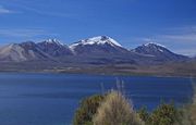
Licancabur . The summit area is in Chile.
Acotango volcano seen from Chile.
See also [ edit ]
^ In vulcanology and this article active volcanoes are those with Holocene eruption, that means eruptions in the last 10,000 years.
References [ edit ]
Northern Volcanic Zone Central Volcanic Zone Southern Volcanic Zone Austral Volcanic Zone Note: volcanoes are ordered by latitude from north to south

 Sajama, a stratovolcano considered extinct.
 View of Licancabur. The summit area is in Chile.
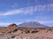
 Acotango volcano seen from Chile.


