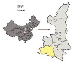
Mian County
Mian County
勉县 | |
|---|---|
 Location in Hanzhong | |
 Hanzhong in Shaanxi | |
| Country | People's Republic of China |
| Province | Shaanxi |
| Prefecture-level city | Hanzhong |
| Area | |
• Total | 2,406 km2 (929 sq mi) |
| Highest elevation | 2,621 m (8,599 ft) |
| Lowest elevation | 513 m (1,683 ft) |
| Population (2019) | |
• Total | 411,991[1] |
| Time zone | UTC+8 (China standard time) |
| Postal code | 724200 |
| Licence plates | 陕F |
| Website | www |
Mian County or Mianxian (simplified Chinese: 勉县; traditional Chinese: 勉縣; pinyin: Miǎn Xiàn) is a county of Hanzhong, in the southwest of Shaanxi province, China, bordering Gansu province to the northwest. Its area measures 2,406 km2 (929 sq mi), and its total population as of 2020 was 429,000 people.[2] During the Qin and Han dynasty it was known as Mianshui (沔水). In 1964 it was renamed to Mianxian with a homophone character for Mian, to avoid the use of uncommon characters in place names. In 2020, the county government requested the name of the county to be changed to Mianzhou (沔州市), pending central government approval. Previously the government requested to use the name Dingjunshan City, but this was denied by the central government.[3]
The tomb of Zhuge Liang near Mount Dingjun is located in the county.
Transportation
Mian County is served by the Yangpingguan–Ankang Railway.
Administrative divisions
Mian County has 19 subordinate towns:
| # | Name | Simplified Chinese | Hanyu Pinyin |
|---|---|---|---|
| 1 | Mianyang | 勉阳镇 | Miǎnyáng Zhèn |
| 2 | Zhoujiashan | 周家山镇 | Zhōujiāshān Zhèn |
| 3 | Tonggousi | 同沟寺镇 | Tónggōusì Zhèn |
| 4 | Xinjiezi | 新街子镇 | Xīnjiēzi Zhèn |
| 5 | Laodaosi | 老道寺镇 | Lǎodàosì Zhèn |
| 6 | Dingjunshan | 定军山镇 | Dìngjūnshān Zhèn |
| 7 | Wenquan | 温泉镇 | Wēnquán Zhèn |
| 8 | Yuandun | 元墩镇 | Yuándūn Zhèn |
| 9 | Xinpu | 新铺镇 | Xīnpù Zhèn |
| 10 | Chadian | 茶店镇 | Chádiàn Zhèn |
| 11 | Wuhou | 武侯镇 | Wǔhóu Zhèn |
| 12 | Baocheng (Paocheng) | 褒城镇 | Bāochéng Zhèn |
| 13 | Jinquan | 金泉镇 | Jīnquán Zhèn |
| 14 | Fuchuan | 阜川镇 | Fùchuān Zhèn |
| 15 | Qingyangyi | 青羊驿镇 | Qīngyángyì Zhèn |
| 16 | Qishuba | 漆树坝镇 | Qīshùbà Zhèn |
| 17 | Zhanggouhe | 长沟河镇 | Zhǎnggōuhé Zhèn |
| 18 | Zhenchuan | 镇川镇 | Zhènchuān Zhèn |
| 19 | Zhangjiahe | 张家河镇 | Zhāngjiāhé Zhèn |
Climate
| Climate data for Mianxian (1981−2010) | |||||||||||||
|---|---|---|---|---|---|---|---|---|---|---|---|---|---|
| Month | Jan | Feb | Mar | Apr | May | Jun | Jul | Aug | Sep | Oct | Nov | Dec | Year |
| Record high °C (°F) | 19.5 (67.1) |
21.8 (71.2) |
29.1 (84.4) |
32.4 (90.3) |
35.1 (95.2) |
38.0 (100.4) |
37.7 (99.9) |
37.9 (100.2) |
37.0 (98.6) |
29.7 (85.5) |
22.3 (72.1) |
18.7 (65.7) |
38.0 (100.4) |
| Mean daily maximum °C (°F) | 7.2 (45.0) |
9.9 (49.8) |
14.7 (58.5) |
21.0 (69.8) |
25.7 (78.3) |
28.4 (83.1) |
29.7 (85.5) |
29.0 (84.2) |
24.2 (75.6) |
19.0 (66.2) |
13.3 (55.9) |
8.2 (46.8) |
19.2 (66.6) |
| Daily mean °C (°F) | 2.8 (37.0) |
5.4 (41.7) |
9.6 (49.3) |
15.2 (59.4) |
19.9 (67.8) |
23.3 (73.9) |
25.1 (77.2) |
24.4 (75.9) |
19.9 (67.8) |
14.8 (58.6) |
8.9 (48.0) |
3.8 (38.8) |
14.4 (58.0) |
| Mean daily minimum °C (°F) | −0.5 (31.1) |
1.8 (35.2) |
5.6 (42.1) |
10.6 (51.1) |
15.1 (59.2) |
19.1 (66.4) |
21.4 (70.5) |
20.7 (69.3) |
16.8 (62.2) |
11.8 (53.2) |
5.6 (42.1) |
0.6 (33.1) |
10.7 (51.3) |
| Record low °C (°F) | −6.9 (19.6) |
−5.0 (23.0) |
−4.2 (24.4) |
0.6 (33.1) |
5.5 (41.9) |
11.2 (52.2) |
15.5 (59.9) |
14.2 (57.6) |
9.4 (48.9) |
−1.8 (28.8) |
−3.1 (26.4) |
−10.2 (13.6) |
−10.2 (13.6) |
| Average precipitation mm (inches) | 5.9 (0.23) |
9.6 (0.38) |
24.3 (0.96) |
43.3 (1.70) |
78.6 (3.09) |
87.0 (3.43) |
170.2 (6.70) |
137.1 (5.40) |
137.8 (5.43) |
61.9 (2.44) |
23.9 (0.94) |
7.7 (0.30) |
787.3 (31) |
| Average relative humidity (%) | 76 | 73 | 73 | 73 | 72 | 74 | 80 | 81 | 83 | 83 | 82 | 79 | 77 |
| Source: China Meteorological Data Service Center[4] | |||||||||||||
References
- ^ "China : Population - ceicdata.com". ceicdata. Retrieved 2021-01-05.
- ^ "勉县介绍 - 勉县介绍 - 勉县人民政府". www.mianxian.gov.cn. Retrieved 2021-03-26.
- ^ "陕西勉县将按程序上报新市名"沔州市",放弃"定军山市"_地名". www.sohu.com. Retrieved 2021-03-26.
- ^ 中国地面气候标准值月值(1981-2010) (in Simplified Chinese). China Meteorological Data Service Center. Retrieved 24 November 2022.
33°9′N 106°40′E / 33.150°N 106.667°E
