Mont-Bellevue, Quebec
Appearance
Mont-Bellevue | |
|---|---|
Borough | |
| Borough of Sherbrooke | |
 Mount Bellevue | |
 | |
| Country | Canada |
| Province | Quebec |
| Region | Estrie |
| RCM | Sherbrooke |
| Merged | January 1, 2002 |
| Government | |
| • City councillors | Nicole A. Gagnon Serge Paquin Robert Pouliot Jean-François Rouleau |
| Area | |
| • Land | 28.5 km2 (11.0 sq mi) |
| Population (2009) | |
• Total | 31,042 |
| • Density | 1,089.19/km2 (2,821.0/sq mi) |
| Time zone | UTC-5 (EST) |
| Area code | 819 |
| Website | Borough of Mont-Bellevue |
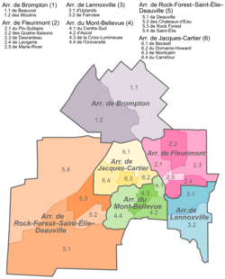
Mont-Bellevue is an arrondissement, or borough, of the city of Sherbrooke, Quebec, Canada. It comprises the former town of Ascot and the southern portion of pre-amalgamation Sherbrooke. The eponymous mountain forms Mont-Bellevue Park in the city centre. The borough is represented by four councillors on the Sherbrooke City Council.
References
[edit]- ^ "Portrait". Mont-Bellevue (in French). Ville de Sherbrooke. 2008-01-28. Retrieved 12 March 2012.
