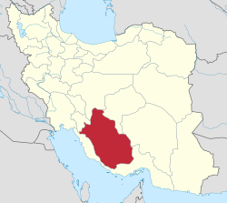
Pasargad County
Pasargad County
شهرستان پاسارگاد | |
|---|---|
 Location of Pasargad County in Fars province | |
 Location of Fars province in Iran | |
| Coordinates: 30°08′N 53°10′E / 30.133°N 53.167°E | |
| Country | |
| Province | Fars |
| Capital | Saadat Shahr |
| Districts | 2 (2006) |
| Population (2006) | |
| • Total | 29,825 |
| Time zone | UTC+3:30 (IRST) |
| • Summer (DST) | UTC+4:30 (IRDT) |
Pasargad County (Persian: شهرستان پاسارگاد) is located in Fars province, Iran. The capital of the county is Saadat Shahr. At the 2006 census, the county's population was 29,825, in 7,100 families.[1]
Administrative divisions
| Administrative Divisions | Pop. |
|---|---|
| Central District | 23,654 |
| Kamin Rural District | 5,522 |
| Sarpaniran Rural District | 2,185 |
| Saadat Shahr City | 15,947 |
| Pasargad District | 6,171 |
| Abu ol Verdi Rural District | 2,451 |
| Madar-e Soleyman Rural District | 3,720 |
| Total Pasargad County | 29,825 |
| Administrative Divisions | Pop. |
|---|---|
| Central District | 23,957 |
| Kamin Rural District | |
| Sarpaniran Rural District | |
| Saadat Shahr City | 17,131 |
| Pasargad District | 6,161 |
| Abu ol Verdi Rural District | |
| Madar-e Soleyman Rural District | |
| Madar-e Soleyman City | 1,546 |
| Total Pasargad County | 30,118 |
References
- ^ a b "Census of the Islamic Republic of Iran, 1385 (2006)" (Excel). Statistical Center of Iran. Archived from the original on 2011-09-20.
Wikimedia Commons has media related to Pasargad County.

