
Puolanka
Puolanka | |
|---|---|
Municipality | |
| Puolangan kunta Puolanka kommun | |
 Puolanka Church | |
 Coat of arms | |
 Location of Puolanka in Finland | |
| Coordinates: 64°52′05″N 027°40′15″E / 64.86806°N 27.67083°E | |
| Country | |
| Region | Kainuu |
| Sub-region | Kehys-Kainuu |
| Government | |
| • Mayor | Harri Peltola |
| Area (2018-01-01)[1] | |
| • Total | 2,598.68 km2 (1,003.36 sq mi) |
| • Land | 2,461.17 km2 (950.26 sq mi) |
| • Water | 137.3 km2 (53.0 sq mi) |
| • Rank | 24th largest in Finland |
| Population (2023-12-31)[2] | |
| • Total | 2,359 |
| • Rank | 242nd largest in Finland |
| • Density | 0.96/km2 (2.5/sq mi) |
| Population by native language | |
| • Finnish | 98% (official) |
| • Swedish | 0.2% |
| • Others | 1.8% |
| Population by age | |
| • 0 to 14 | 9.1% |
| • 15 to 64 | 51.5% |
| • 65 or older | 39.5% |
| Time zone | UTC+02:00 (EET) |
| • Summer (DST) | UTC+03:00 (EEST) |
| Website | www.puolanka.fi |
Puolanka (Finnish: [ˈpuo̯lɑŋkɑ] ;Swedish: Puolanka, also Puolango) is a municipality in Finland located in the Kainuu region. The municipality has a population of 2,359 (31 December 2023)[2] and covers an area of 2,598.68 square kilometres (1,003.36 sq mi) of which 137.3 km2 (53.0 sq mi) is water.[1] The population density is 0.96 inhabitants per square kilometre (2.5/sq mi). The municipality is unilingually Finnish.
The fir-tree topped line in the coat of arms of Puolanka refers to local forestry and the cattle bells to livestock management and past grazing in forest lands. The coat of arms was designed by Aake Kaarnama, and the Puolanka municipal council approved it at its meeting on 8 June 1962. The Ministry of the Interior approved the coat of arms for use on 29 August of the same year.[6]
Puolanka has been called the "most pessimistic municipality in Finland".[7] In 2019, the municipality gained worldwide publicity when the BBC published a video about Puolanka, describing it as the "most pessimistic town in the world".[8] Pessimism has a long tradition in the Kainuu region, and the residents of Puolanka decided to make it their trademark, which is why the residents organize various events related to the topic every year.[7]
History[edit]
The first permanent settlers in Puolanka came in the 1550s.[9]
The municipality of Puolanka was established in the year of 1867. In that same year the Puolanka parish became independent from the Hyrynsalmi church to which it had previously belonged to administratively. The municipal council of Puolanka was formed in the year of 1916.[9]
At its peak Puolanka had a population of about 7,520 in 1960. Towards the end of the 1960s, however, Puolanka's population began to decline, alike other municipalities within Kainuu.[9]
Geography[edit]
Ranked one of the most beautiful waterfalls in Finland, the 24-metre-high (79 ft) Hepoköngäs, is located 16 kilometres (10 mi) from the center of Puolanka.
| Climate data for Puolanka Kotila (1991-2020 normals) | |||||||||||||
|---|---|---|---|---|---|---|---|---|---|---|---|---|---|
| Month | Jan | Feb | Mar | Apr | May | Jun | Jul | Aug | Sep | Oct | Nov | Dec | Year |
| Average precipitation mm (inches) | 55 (2.2) |
47 (1.9) |
43 (1.7) |
37 (1.5) |
64 (2.5) |
74 (2.9) |
99 (3.9) |
88 (3.5) |
75 (3.0) |
80 (3.1) |
76 (3.0) |
68 (2.7) |
806 (31.7) |
| Average precipitation days (≥ 0.1 mm) | 23 | 19 | 16 | 14 | 16 | 16 | 18 | 17 | 18 | 21 | 23 | 23 | 224 |
| Source: https://www.ilmatieteenlaitos.fi/1991-2020-sadetilastot | |||||||||||||
Villages[edit]
Villages within Puolanka are as follows:
- Aittokylä
- Auho
- Joukokylä
- Kivarinjärvi
- Kotila
- Kongasmäki
- Leipivaara
- Lylykylä
- Naulaperä
- Puokio
- Puolanka
- Rasinkylä
- Suolijärvi
- Vihajärvi
- Väyrylä
- Yli-Oterma
- Törmänmäki
Notable individuals[edit]
- Juha Sipilä, the Prime Minister of Finland 2015−2019
- Kalle Määttä, volleyball player
- Kaarina Mähönen, poet
- Kari Hiltunen, sports journalist
- Kimmo Saneri, writer
- Lasse Väisänen, footballer
- Louis Moilanen, giant
- Markku Kukkoaho, sprinter
- Santeri Haapanen, politician
- Tauno Tarkkinen, writer
- Tuulikki Pyykkönen, Olympic cross-country skier
- Unto Väisänen, baseball player
Gallery[edit]
-
 Lake Kalettomanlampi in Puolanka, seen from the southernmost shore towards northeast.
 -
 With its drop of 24 meters, Hepoköngäs is the highest waterfall in Kainuu.
 -
 The river Keskijoki in Puolanka.
 -
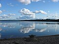 The lake of Pirttijärvi in Puolanka, seen from the beach at the North-Western end of the lake towards southeast.


References[edit]
- ^ a b "Area of Finnish Municipalities 1.1.2018" (PDF). National Land Survey of Finland. Retrieved 30 January 2018.
- ^ a b "Immigration record high in Finland in 2023". StatFin. Statistics Finland. Retrieved 25 January 2024.
- ^ "Demographic Structure by area as of 31 December 2022". Statistics Finland's PX-Web databases. Statistics Finland. Retrieved 6 September 2023.
- ^ "Population according to age (1-year) and sex by area and the regional division of each statistical reference year, 2003–2020". StatFin. Statistics Finland. Retrieved 2 May 2021.
- ^ a b "Luettelo kuntien ja seurakuntien tuloveroprosenteista vuonna 2023". Tax Administration of Finland. 14 November 2022. Retrieved 7 May 2023.
- ^ Suomen kunnallisvaakunat (in Finnish). Suomen Kunnallisliitto. 1982. p. 157. ISBN 951-773-085-3.
- ^ a b "Pessimistinen Puolanka". Yle (in Finnish). 3 January 2020. Retrieved 25 November 2023.
- ^ "The world's most pessimistic town". BBC. 1 November 2019. Retrieved 25 November 2023.
- ^ a b c "Historia". www.puolanka.fi. Retrieved 2016-07-14.
External links[edit]
![]() Media related to Puolanka at Wikimedia Commons
Media related to Puolanka at Wikimedia Commons
![]() Puolanka travel guide from Wikivoyage
Puolanka travel guide from Wikivoyage
Places adjacent to Puolanka | |
|---|---|
| Municipalities |  | |
|---|---|---|
| Former municipalities | ||
This Oulu Province location article is a stub. You can help Wikipedia by expanding it. |