
Salar de Atacama


Salar de Atacama is the largest salt flat in Chile.[1] It is located 55 km (34 mi) south of San Pedro de Atacama, is surrounded by mountains and has no drainage outlets. To the east is enclosed by the main chain of the Andes, while to the west lies a secondary mountain range of the Andes called Cordillera de Domeyko. Large volcanoes dominate the landscape, including the Licancabur, Acamarachi, Aguas Calientes and the Láscar. The latter is one of the most active volcanoes in Chile. All of them are located along the eastern side of the Salar de Atacama, forming a generally north-south trending line of volcanoes that separate it from smaller endorheic basins.[2]
Features
The salt flat encompasses 3,000 km², is about 100 km long[1] and 80 km wide, which makes it Americas' second largest and is also the second in the world, after Salar de Uyuni in Bolivia (10,582 km²).[3] Its average elevation is about 2,300 m asl.[1] The topography of the core portion of the salar exhibits a high level of roughness, which is due to that the surface of this area is permanently free of water,[4] unlike the most of the other salt flats, as for example the Salar de Uyuni, which is periodically covered with shallow water. Some areas of the salt flat form part of Los Flamencos National Reserve. The Lagunas Cejar is a sink hole lake in the Salar de Atacama, 18 km from San Pedro, Chile. It has a 40% concentration of salt, producing an effect of floating like the Dead Sea.[citation needed]
Lithium production
The Salar of Atacama is the world's largest and purest active source of lithium,[5] contains 27 percent of the world's lithium reserve base,[6] and as of 2008 provided almost 30 percent of the world's lithium carbonate supply, followed by China with 23 percent.[5][6] Thanks to its brine's high lithium concentration, averaging 2,700 parts per million, its high rate of evaporation, 3,500 millimeters per year, and its low annual rainfall of just a few millimeters per year, Atacama's finished lithium carbonate is easier to produced and cheaper than the one that could be produced from the neighboring Salar de Uyuni, which is estimated to have half of the lithium reserves in the world. Atacama's has the highest rate of evaporation in the lithium industry, followed by Puna de Atacama, Argentina, with 2,600 mm per year, and the Salar de Uyuni, Bolivia, with a rate of 1,300 to 1,700 mm per year.[5]
Gallery
-
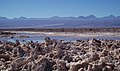 Salar d'Atacama
 -
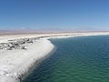 Laguna Cejar
 -
 Laguna Miscanti
 -
 Andean flamingos


References
- ^ a b c "The Optical/Infrared Astronomical Quality of High Atacama Sites" (PDF). Retrieved 2007-04-24.
- ^ Template:Es icon Cuenca del Salar de Atacama
- ^ "Salar de Uyuni, Bolivia". NASA Earth Observatory. Retrieved 2007-12-01.
- ^ Kampf, Stephanie (2005). "Evaporation and land surface energy budget at the Salar de Atacama, Northern Chile". Journal of Hydrology. 310 (1–4): 236–252. doi:10.1016/j.jhydrol.2005.01.005.
{{cite journal}}:|access-date=requires|url=(help); Unknown parameter|coauthors=ignored (|author=suggested) (help) - ^ a b c Fletcher, Seth (2011). Bottled Lightning: Superbatteries, Electric Cars, and the New Lithium Economy. Hill and Wang, New York. ISBN 978-0809030538.
{{cite book}}: Cite has empty unknown parameter:|1=(help) Chapter 10: The Lithium Triangle, pp. 186-187 - ^ a b Brendan I. Koerner (2008-10-30). "The Saudi Arabia of Lithium". Forbes. Retrieved 2011-05-12. Published on Forbes Magazine dated November 24, 2008.
23°30′S 68°15′W / 23.500°S 68.250°W
This Antofagasta Region location article is a stub. You can help Wikipedia by expanding it. |