Stonehenge Avenue
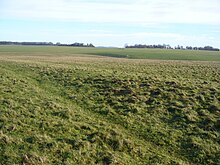
 The Avenue at Stonehenge looking ENE towards Old and New King Barrows | |
The Avenue, shown within the Stonehenge section of the Stonehenge and Avebury World Heritage Site | |
| Region | Wiltshire |
|---|---|
| Coordinates | 51°10′44″N 1°49′31″W / 51.179°N 1.8253°W |
| Type | avenue |
| History | |
| Periods | Neolithic |
| Site notes | |
| Excavation dates | from 1740, 2013 |
| Archaeologists | William Stukeley, Heather Sebire |
| Condition | Excellent |
| Public access | Yes |
| Website | National Trust |
| Type | Cultural |
| Criteria | i, ii, iii |
| Designated | 1986 (10th session) |
| Reference no. | 373 |
| Region | Europe and North America |
| Designated | 1882 |
| Reference no. | 1010140[1] |
Stonehenge Avenue is an ancient avenue on Salisbury plain, Wiltshire, England. It is part of the Stonehenge, Avebury and Associated Sites UNESCO World Heritage Site. Discovered in the 18th century, it measures nearly 3 kilometers,[2] connecting Stonehenge with the River Avon.[3] It was built during the Stonehenge 3 period of 2600 to 1700 BCE.
Along some of its length The Avenue is aligned with the sunrise of the summer solstice,[3] suggesting a time of most frequent use.[2] In 2013 a section of A344 road was closed, which had cut through the Avenue close to Stonehenge. After the road surface was removed, it was shown that although the Avenue's banks had been sliced off, the filled in ditches were still in evidence, demonstrating that the Avenue had indeed connected right through to the stone circle.[4]
At the end of the Avenue, a ring of pits, referred to as Bluestonehenge, was discovered in 2009. No monoliths were found, and stone chips which were assumed to be of bluestone were later found to bear no relation to the bluestones at Stonehenge. [5][6]
Mike Parker Pearson of the Stonehenge Riverside Project believes that the Avenue was inspired by, and built over top of a natural formation of rills with an existing astronomical alignment.[7]
The Avenue, along with Stonehenge itself, is a Scheduled Monument, first designated in the 1882 act which was the earliest legislation to protect British archaeological sites.[8]
References
- ^ Historic England. "English Heritage Scheduled Monument record (1010140)". National Heritage List for England. Retrieved 15 January 2015: 'Stonehenge, the Avenue, and three barrows adjacent to the Avenue forming part of a round barrow cemetery on Countess Farm'
- ^ a b "The Avenue - An Overview". English Heritage (Internet Archive). Archived from the original on 10 November 2013.
{{cite web}}: Italic or bold markup not allowed in:|publisher=(help); Unknown parameter|deadurl=ignored (|url-status=suggested) (help) - ^ a b "Huge Settlement Unearthed At Stonehenge Complex". ScienceDaily. 30 January 2007.
- ^ Summer Discoveries at Stonehenge, English Heritage, 10 September 2013.
- ^ "Mini-Stonehenge find 'important'". BBC News. 3 October 2009. Retrieved 24 May 2010.
- ^ http://www.stone-circles.org.uk/stone/avenue.htm
- ^ "...sits upon a series of natural landforms that, by chance, form an axis between the directions of midsummer sunrise and midwinter sunset", 22 June 2012, University of Sheffield
- ^ Hunter, Robert (1907). . The Preservation of Places of Interest or Beauty. Manchester University Press – via Wikisource.


