T'Boli, South Cotabato
T'Boli | |
|---|---|
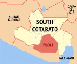
 Map of South Cotabato showing the location of T'Boli | |
| Country | |
| Region | SOCCSKSARGEN (Region XII) |
| Province | South Cotabato |
| Barangays | 25 |
| Government | |
| • Mayor | Dibu S. Tuan |
| Area | |
| • Total | 895.83 km2 (345.88 sq mi) |
| Population (2010) | |
| • Total | 79,175 |
| • Density | 88/km2 (230/sq mi) |
| Time zone | UTC+8 (PST) |
| ZIP code | 9513 |
| Dialing code | 83 |
| Income class | 1st |
| Website | www |
| Year | Pop. | ±% p.a. |
|---|---|---|
| 1990 | 26,346 | — |
| 1995 | 54,206 | +14.47% |
| 2000 | 60,693 | +2.45% |
| 2007 | 70,609 | +2.11% |
| 2010 | 79,175 | +4.25% |
| Source: National Statistics Office[2] | ||
T'Boli is a 1st class municipality in the province of South Cotabato, Philippines. According to the 2010 census,[3] it has a population of 79,175 people in 14,760 households.
Barangays
T'boli is politically subdivided into 25 barangays.
|
|
References
- ^ "Official City/Municipal 2013 Election Results". Intramuros, Manila, Philippines: Commission on Elections (COMELEC). 1 July 2013. Retrieved 5 September 2013.
- ^ "Total Population by Province, City, Municipality and Barangay: as of May 1, 2010". 2010 Census of Population and Housing. National Statistics Office. Retrieved 6 October 2013.
{{cite web}}: Cite has empty unknown parameter:|1=(help) - ^ http://census.gov.ph/data/census2010/index.html
External links

