
Ulen, Minnesota
Ulen | |
|---|---|
 Commercial district | |
 Location of Ulen, Minnesota | |
 Ulen  Ulen | |
| Coordinates: 47°04′42″N 96°15′29″W / 47.07833°N 96.25806°W | |
| Country | United States |
| State | Minnesota |
| County | Clay |
| Government | |
| • Type | Mayor-Council |
| • Mayor | Mary A. Knopfler |
| Area | |
| • Total | 1.07 sq mi (2.77 km2) |
| • Land | 1.07 sq mi (2.77 km2) |
| • Water | 0.00 sq mi (0.00 km2) |
| Elevation | 1,148 ft (350 m) |
| Population | |
| • Total | 476 |
| • Estimate (2021)[4] | 484 |
| • Density | 444.86/sq mi (171.83/km2) |
| Time zone | UTC-6 (CST) |
| • Summer (DST) | UTC-5 (CDT) |
| ZIP code | 56585 |
| Area code | 218 |
| FIPS code | 27-66136 |
| GNIS feature ID | 2397080[2] |
| Website | ulenmn.org |
Ulen (/ˈjuːlən/ YOO-lən) is a city in Clay County, Minnesota, United States, along the South Branch of the Wild Rice River. The population was 476 at the 2020 census.[3]
Near this small community, what may be an authentic Viking sword known as the Ulen sword was found in a field by Hans O. Hansen in 1911. The sword is currently on display in the Ulen Museum. Ulen and the area surrounding is mostly inhabited by later generation Norwegian-Americans.
Ulen is the southern terminus of the Agassiz Recreational Trail, a 53-mile multi-use trail built on an abandoned railroad grade which has its northern terminus at Crookston, Minnesota.[5] As of 2022, the mayor of Ulen is Mary A. Knopfler.
History[edit]
Ulen Township was named after an early European to settle in the region, Ole Ulen. Ulen was incorporated as a village on November 12, 1896. A meeting was held on June 7, 1881 at the home of Nels Wiger for the purpose of organizing Ulen Township. Robert Hanson, Elias Rost and Ole Mellum were the election judges and Nels Wiger served as the clerk. One of the concerns of the early township officials was the building of roads. There were no tax funds for this purpose so each able-bodied man was required to work for two days a year building roads. The first road was laid out and built in 1883.[6]

The post office was established in 1884, its name changing to Odneland in 1885 for Ole Odneland (Tallak Aaneland), postmaster and general store owner, although it was sometimes spelled Oneland and Onland. When the railroad came in 1886, Odneland's (Aaneland's) store was in the path of the rails, so it was moved to the east side of the tracks on the northwest corner of Regelstad's farm. In 1866, the same year Ulen was incorporated, the Duluth and Manitoba Railway company, a subsidiary of the Northern Pacific Railway, built the railroad between what is now known as Manitoba Junction and Red Lake Falls, taking the railroad directly through Ulen.[7] Ole Asleson platted a townsite, and the name was changed to Ulen with Odneland remaining as postmaster until the post office was reorganized in 1887 and Ole Christian Melbye became postmaster in his grocery store; Melbye moved into the first house built in village limits in 1887. Ulen came to be mostly inhabited by Norwegian immigrants and the town continues to hold on to its nordic identity.[8]
The Ulen Historical Society was founded in September 1963. In 2004 a new Ulen Historical Society was organized.[9]
The Ulen Historical Society runs the Ulen Museum, home to the Ulen Sword. The Ulen Sword is 19th century sword, once believed to be a Viking sword, which the town takes great pride in. The sword was found by Hans O. Hansen on his farm while plowing in 1911. The former name of the Ulen Museum was the Viking Sword Museum.
The town has been able to grow slowly over the years in part thanks to Northwestern Bank. In 1941, the bank moved to Ulen and changed its name to Northwestern Bank. One of the historic events of the bank occurred in 1958 when the bank reached 1 million dollar figure in deposits. This first branch in Ulen is still economically important. Over the years it has been slowly able to grow and expand. Eventually starting branches in Moorhead and other rural communities in northwestern Minnesota. Their branch in Ulen however has still been able to thrive and is an important business in the local economy and community, providing crucial service.[10]

In 2005 Ulen needed to get the arsenic out of its water. Wells supplying the city’s water had high concentrations of the chemical-more than twice the treatment standard of less than 10 parts per billion. Also the city was experiencing too many water main breaks, and its aging infrastructure needed replacing. As a result, Moore Engineering planned and designed a gravity filter system to remove arsenic from the water supply and made plans to replace aging water mains. The city’s new water treatment plant removed arsenic to a level of less than 5 parts per billion, 50 percent more treatment than required. Grants and loans, including a $600,000 grant from the Small Cities Community Development program, helped pay for the improvements, ensuring water safety.
Historically known as an agricultural community, Ulen continues to flourish with the growth of agricultural and small family-owned businesses. [11] West Central Ag Service operates the grain elevator in Ulen
Geography[edit]
Ulen is a small agricultural town on the prairie of western Minnesota in Clay County, located about 40 miles east of Fargo, North Dakota. According to the United States Census Bureau, the city has a total area of 1.07 square miles (2.77 km2), all land.[12] State Highway 32 serves as a major arterial in the community. Ulen's zip code is 56585. Ulen is the southern terminus of the Agassiz Recreational Trail, a 53-mile multi-use trail built on an abandoned railroad grade which has its northern terminus at Crookston, Minnesota.
Demographics[edit]
Since 1900, the population has never fallen below 300 or risen above 600, reaching a peak of 590 in the 1920s. Today about 480 people reside in Ulen, making it one of over 12,000 incorporated places in the United States with fewer than 2,500 citizens, the population below which the US Census Bureau defines an area to be rural.[13] As of 2022 the town of Ulen has the 8th highest amount of Norwegian Americans, relative to its total population, in the state of Minnesota.[14]
| Census | Pop. | Note | %± |
|---|---|---|---|
| 1900 | 317 | — | |
| 1910 | 438 | 38.2% | |
| 1920 | 590 | 34.7% | |
| 1930 | 452 | −23.4% | |
| 1940 | 562 | 24.3% | |
| 1950 | 525 | −6.6% | |
| 1960 | 481 | −8.4% | |
| 1970 | 486 | 1.0% | |
| 1980 | 514 | 5.8% | |
| 1990 | 547 | 6.4% | |
| 2000 | 532 | −2.7% | |
| 2010 | 547 | 2.8% | |
| 2020 | 476 | −13.0% | |
| 2021 (est.) | 484 | [4] | 1.7% |
| U.S. Decennial Census[15] 2020 Census[3] | |||
2020 census[edit]

As of the census of 2020,[16] there were 476 people, 204 households, and 99 families living in the city. The population density was 444.8 inhabitants per square mile (171.7/km2). There were 241 housing units at an average density of 225.2 per square mile (87.0/km2). The racial makeup of the city was 90.9% White, 3.5% Native American, 0.6% from other races, and 4.8% from two or more races. Hispanic or Latino of any race were 0.6% of the population. A majority of Ulen has Norwegian ancestry.
There were 204 households, of which 17% had children under the age of 18 living with them, 31.9% were married couples living together, 9.3% had a female householder with no husband present, 7.4% had a male householder with no wife present, and 51.5% were non-families. 48.5% of all households were made up of individuals, and 30.4% had someone living alone who was 65 years of age or older. The average household size was 1.84 and the average family size was 2.66.
The median age in the city was 63.4 years. 17% of residents were under the age of 18; 1% were between the ages of 18 and 24; 13.6% were from 25 to 44; 21.6% were from 45 to 64; and 47% were 65 years of age or older. The gender makeup of the city was 42.3% male and 47.7% female.
2010 census[edit]

As of the census of 2010, there were 547 people, 234 households, and 130 families living in the city. The population density was 479.8 inhabitants per square mile (185.3/km2). There were 268 housing units at an average density of 235.1 per square mile (90.8/km2). The racial makeup of the city was 93.1% White, 0.4% African American, 3.7% Native American, 0.2% Asian, 0.5% from other races, and 2.2% from two or more races. Hispanic or Latino of any race were 0.5% of the population. A majority of Ulen has Norwegian ancestry.
There were 234 households, of which 26.9% had children under the age of 18 living with them, 43.2% were married couples living together, 8.1% had a female householder with no husband present, 4.3% had a male householder with no wife present, and 44.4% were non-families. 39.7% of all households were made up of individuals, and 21.8% had someone living alone who was 65 years of age or older. The average household size was 2.16 and the average family size was 2.89.
The median age in the city was 46.6 years. 21.2% of residents were under the age of 18; 5.3% were between the ages of 18 and 24; 21.5% were from 25 to 44; 23.9% were from 45 to 64; and 28% were 65 years of age or older. The gender makeup of the city was 49.4% male and 50.6% female.
2000 census[edit]
As of the census of 2000, there were 532 people, 203 households, and 120 families living in the city. The population density was 488.9 inhabitants per square mile (188.8/km2). There were 228 housing units at an average density of 209.5 per square mile (80.9/km2). The racial makeup of the city was 99.25% White and 0.75% Native American. Hispanic or Latino of any race were 0.19% of the population. A majority of Ulen has Norwegian ancestry.
There were 203 households, out of which 28.6% had children under the age of 18 living with them, 44.3% were married couples living together, 9.9% had a female householder with no husband present, and 40.4% were non-families. 35.5% of all households were made up of individuals, and 26.1% had someone living alone who was 65 years of age or older. The average household size was 2.24 and the average family size was 2.88.
In the city, the population was spread out, with 23.3% under the age of 18, 5.8% from 18 to 24, 19.9% from 25 to 44, 16.9% from 45 to 64, and 34.0% who were 65 years of age or older. The median age was 46 years. For every 100 females, there were 88.7 males. For every 100 females age 18 and over, there were 78.2 males.
The median income for a household in the city was $27,813, and the median income for a family was $42,188. Males had a median income of $33,036 versus $20,000 for females. The per capita income for the city was $16,593. About 5.0% of families and 8.5% of the population were below the poverty line, including 8.3% of those under age 18 and 15.6% of those age 65 or over.
Government[edit]
Ulen has a mayor–council form of government. Ulen's current mayor is Mary A. Knopfler, who was elected in 2018,[citation needed] and reelected in 2022.[17]
The representative body of the city of Ulen is the city council. The council members include James Ashmore, Jeremy Bagg, Randy Zimmerman, and Kim Syverson. Sandy Braseth is the appointed clerk/treasurer.[18][unreliable source?]
At the State Legislature level, Ulen's Representative is Debra L. Kiel with them being in the District 1B. Ulen used to be in District 4B until after the 2020 redistricting cycle. Ulen's State Senator is Mark Johnson with them being in District 1. Ulen used to be in District 4 until after the 2020 redistricting cycle. Both are Republicans. At the Federal Level Amy Klobuchar and Tina Smith are Minnesota Senators with them being Democrats. Michelle Fischbach represents Ulen in the U.S. House being from Minnesota's 7th District and a Republican.[19]
Economy[edit]

Ulen has an economy primarily made up of agriculture services and farms. The grain elevator in Ulen is run by West Central Ag Service, and is one of the largest in the state of Minnesota, and has currently more than 190 workers. This greatly benefits Ulen and the surrounding area, causing Ulen to be the agricultural hub of the surrounding towns.[citation needed] The West Central Ag Service business offices and service shop are both located in Ulen.[20] The Nordic Lounge, Viking Manor, Sanford Health Clinic, Northwestern Bank, Ulen Building and Supply, and the West Central Ag Service Ulen Convince Store, are important businesses in the community. [21]
Utilities[edit]
The Otter Tail Power Company provides electricity to the town with telephone and cable TV being provided by Arvig.[22]
Prominent businessmen[edit]
Ole Evans, a well known resident of Ulen township, now deceased, was the son of Arne (also deceased) and Julia (Ulen) Evans, who settled in Ulen township with their family in the year 1881. Ole was born in the town of Cuba, in Becker county, Minnesota, on November 12, 1871, and died in October, 1903. He married Miss Gusta Hanson on August 9, 1898, and they had one son, Raymond.
Evans was educated first in the country schools, and later attended school in Grand Forks, North Dakota, the college at Moorhead, and lastly the seminary at Red Wing, Minnesota. He was ten years of age when he came to Ulen with his parents, where he grew to manhood in the highest esteem of his friends. His first business venture was in 1894, when he opened a hardware store in Ulen, and the following year took as a partner O. P. Olson, and the business was conducted under the firm name of Olson & Evans for about four years, when Evans purchased Olson‘s interest and carried on the store from that time on, and at his death he had the largest hardware business in Ulen. He owned the first bicycle in the village and also the first automobile.
Evans was a member of the United Lutheran church, and was one of the most popular men of the county, both in business and socially. The Ulen band played at his funeral services, and all business operations ceased on that day.[23]
‘Ulen’ Wheat[edit]
in 2006 a paper was published to the USDA to classify the wheat planted around Ulen as 'Ulen' Wheat this is due to Ulen being in its region of adaptation.[24]
Education[edit]
The Ulen-Hitterdal Public School is a school in Independent School District #914. It serves the community of Ulen and the neighboring town of Hitterdal. It is a K-12 institution with modern facilities. The school has a number of sports teams. The school mascot is the Titans with the school colors being black, blue, and gold.[25]
Ulen has one library, the Ulen LINK Site. It is a LINK site of the Lake Agassiz Regional Library.[26] Amy Nelson is the current office manager at the Ulen LINK Site.
Culture[edit]

Ulen has a very large Norwegian American population.[27] The Ulen museum, formerly the Viking Sword Museum, Viking Manor, numerous Norse and Viking artifacts found in the area further show to represent the deep pride the town has for its Norwegian heritage. Another manifestation of this pride is, Lena's Lefse, a bakery dedicated to lefse and other Norse baked items.[28]
Memorial[edit]
Located in the center of Ulen on Main street is the Ulen's Veteran's Memorial Wall commemorating Ulen residents who have fought and died in American Wars. The memorial was a joint project by the VFW and the Ulen Lions.[29]
Museum[edit]
The Ulen Museum (formerly the Viking Sword Museum) opened on Sunday, August 4, 2007. The Ulen Museum is located on Ulen's main street (State Highway 32). It is situated on the corner of Spartan Avenue and 1st St. NW. It is run by the Ulen Historical Society and is dedicated to preserving the rich history of Ulen.[30] The Ulen Museum is home to the Ulen Sword. The Ulen Sword is 19th century sword, once believed to be a Viking sword. The sword was found by Hans O. Hansen on his farm while plowing in 1911.The former name of the Ulen Museum was the Viking Sword Museum.
Festival[edit]

Ulen Days (formerly Ulen Turkey Barbecue Days) is an annual event held on the third weekend in August each year and dates back to 1962. The Turkey BBQ includes a wide variety of events held during mid August. The most popular aspect of the festival is the turkey, which regularly is barbecued on Saturday from 3:30 – 6:00pm on “the world’s largest spit.” It includes an entire weekend of activities including shows, sport games and tournaments, raffles, and food trucks. [31][32][33]
Theatre[edit]
The Top Hat Theatre serves as theater group in Ulen.[34] It was created in 2005. Performances are in the Barry J. Houglum Auditorium, a 350 seat theater located in the Ulen-Hitterdal Public School.[35]
Organizations[edit]
Ulen throughout its history has had many organizations. Organizations such as the V.F.W, American Legion, bands, orchestras, and many more. While over the years many of them no longer exist they were vital to the establishing of modern day Ulen.
V.F.W. Post 5115[edit]
The VFW post was organized on December 2, 1945. It was named after Sander Jacobson who lost his life in active duty during World War II. The VFWs first meeting was held in Forsythe's Hall with 65 charting members. An old potato house was rented for the first meeting place in 1946 and continued to be the meeting place until the potato harvest forced the organization to find a new location. The meetings were then moved to any available place until an old store, known as the Brandvold Store, was bought in 1948. This building was used until 1961. when it was torn down and the present building was built. In 1974 a new 40 by 80 foot addition was built. Over the past years the VFW has sponsored and helped many organizations such as school scholarships, Voice of Democracy, baseball teams, softball teams, skating rink, cemetery funds, military funerals, Memorial Day programs, cancer research, Camp Courage, Fire Department, National home, wheel chairs and crutches for the homes and needy people and many more charities.[36][37]
Ulen Lions Organization[edit]
The International Association of Lions Clubs granted a charter to the Ulen Lions on December 7, 1972. Over the years the Ulen Lions have had many large fundraisers. They often raise money for the community through things such as birthday calendars, bingo and raffles. The Lions use this money to provide scholarships to graduating students from the Ulen-Hitterdal Highschool, providing eye glasses for needy in the community and the school. The Lions sponsored and paid for the press box for the highschool football field, made improvements to the softball field and grandstand, at a time offered snowmobile safety classes, provide annual clean-up at the Ulen Park, make donations to the school athletic banquet, Ulen Rescue Squad, Ulen Fire Department, Viking Manor Nursing Home, Ulen Community Choir, video equipment at the school, street signs and they have built a float that represents Ulen's Centennial celebration that used to participate in nearby and local parades.
On the international level, the Ulen Lions, give annually to the LCIF, Leader Dog Fund, Eye Bank, the Hearing Foundation and charter gifts for new clubs. Many of the currents Lions members are active in attending zone meetings and the mid-winter conventions. The Ulen Lions have been sponsoring the Lions Clubs of Hitterdal and Flom as well.[38][39][37]
Other organizations[edit]
At a time Ulen hosted clubs such as the Sand Ridge Saddle Club, the Ulen Gun Club, Ulen Good Neighbors Club, the Ulen Commercial Club and the Ulen Study Club. Ulen continues to host organizations such as the Ulen Parent Teacher Organization, Ulen Historical Association, and Ulen 4-H Clubs. The town as a whole engages in much civic participation and take particular pride in their Historical Association and 4-H Clubs.[37]
Healthcare[edit]

Stanford Health Ulen Clinic is a Stanford Health Clinic dedicated to providing quality service to Ulen and the surrounding community. It provides family medicine, radiology, and has laboratories as well as providing immunizations and mammograms.[40]
Ulen is a large provider for healthcare for senior citizens in the area. The Ulen Senior Citizens Center acts as a communal gathering place for senior citizens in Ulen. [41] The Viking Manor Nursing Home is another healthcare facility in Ulen for its seniors. It is a long term care facility and nursing home. Viking Manor includes 45 beds for seniors.[42][43]
In popular culture[edit]
A 2013 episode of America Unearthed partly focuses on the ancient bones and Ulen Sword found in the area. The episode also includes many references to the town's Norwegian identity and possible Viking exploration in the area.[44]
Gallery[edit]
-
 Street scene, 1913
 -
 Street scene, 1911
 -
 Viking Manor, 1950s
 -
 United Lutheran Church, 1910s
 -
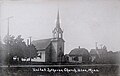
 First South Wild Rice Evangelical Lutheran Church, 1950s
 -
 Public School, Ulen Minnesota, 1940s
 -
 Teacherage, Ulen Public School, 1942
 -
 Ulen Veterans Memorial
 -
 Ulen VFW Post
 -
 Mercantile Store, 1913
 -
 Annual "Turkey Barbecue Days", 1980s
 -
 Band in front of Ulen Cement Company, 1910s
 -
 Ulen Museum


References[edit]
- ^ "2020 U.S. Gazetteer Files". United States Census Bureau. Retrieved July 24, 2022.
- ^ a b U.S. Geological Survey Geographic Names Information System: Ulen, Minnesota
- ^ a b c "Explore Census Data". United States Census Bureau. Retrieved April 21, 2022.
- ^ a b "City and Town Population Totals: 2020-2021". United States Census Bureau. June 8, 2022. Retrieved June 16, 2022.
- ^ Dokken, Brad (24 December 2009), "Construction begins on Agassiz trail bridges", Northland Outdoors, archived from the original on 14 July 2011, retrieved 1 March 2011
- ^ "Home". Ulen Township. Retrieved February 17, 2022.
- ^ Cederström, B. Marcus (2018). ""Everyone Can Come and Remember": History and Heritage at the Ulen Museum". Scandinavian Studies. 90 (3): 376–402. doi:10.5406/scanstud.90.3.0376. ISSN 0036-5637. JSTOR 10.5406/scanstud.90.3.0376. S2CID 166369840.
- ^ "Guide to Ulen Minnesota". www.lakesnwoods.com. Retrieved February 17, 2022.
- ^ "Ulen Museum - About Us". www.ulenmuseum.com. Retrieved May 16, 2022.
- ^ "Four Generations Strong :: Northwestern Bank". www.nwbanks.com. Retrieved February 20, 2022.
- ^ "About the Area". Viking Manor. Retrieved May 20, 2022.
- ^ "US Gazetteer files 2010". United States Census Bureau. Archived from the original on July 2, 2012. Retrieved November 13, 2012.
- ^ Cederström, B. Marcus (2018). ""Everyone Can Come and Remember": History and Heritage at the Ulen Museum". Scandinavian Studies. 90 (3): 376–402. doi:10.5406/scanstud.90.3.0376. ISSN 0036-5637. JSTOR 10.5406/scanstud.90.3.0376. S2CID 166369840.
- ^ "Explore Census Data". data.census.gov. Retrieved January 13, 2023.
- ^ United States Census Bureau. "Census of Population and Housing". Retrieved September 11, 2013.
- ^ "Explore Census Data". data.census.gov. Retrieved May 16, 2022.
- ^ "Winners of the mayor and city council races in Becker County". Detroit Lakes Tribune. November 10, 2022. Retrieved February 3, 2023.
- ^ "Guide to Ulen Minnesota". www.lakesnwoods.com. Retrieved February 17, 2022.
- ^ "Find Your State Legislators - Open States". openstates.org. Retrieved October 17, 2022.
- ^ "About". www.westcentralag.com. Retrieved June 26, 2022.
- ^ "The History of Ulen and Turkey BBQ Days". Retrieved January 11, 2023.
- ^ "Guide to Ulen Minnesota". www.lakesnwoods.com. Retrieved June 26, 2022.
- ^ "Biography of Ole Evans of Ulen Township, Minnesota – Minnesota Genealogy". June 20, 2022. Retrieved January 11, 2023.
 This article incorporates text from this source, which is in the public domain.
- ^ Anderson, J; Busch, Robert; McVey, Donald; Kolmer, James; Linkert, J (2006). Registration of "Ulen" Wheat. United States Department of Agriculture, Agriculture Research Service.
{{cite book}}:|work=ignored (help) - ^ "Ulen-Hitterdal Public Schools". www.ulenhitterdal.k12.mn.us. Retrieved February 17, 2022.
- ^ "Ulen LINK Site". Lake Agassiz Regional Library. Retrieved February 20, 2022.
- ^ "Explore Census Data". data.census.gov. Retrieved February 20, 2022.
- ^ "From Ulen: Ole & Lena would feel right at home in this Minnesota town". Minnesota Prairie Roots. November 8, 2018. Retrieved February 20, 2022.
- ^ "About the Area". Viking Manor. Retrieved May 20, 2022.
- ^ "Ulen Museum - About Us". www.ulenmuseum.com. Retrieved February 16, 2022.
- ^ "Ulen Museum - Formerly known as..." ulenmuseum.com. Retrieved February 16, 2022.
- ^ "The History of Ulen and Turkey BBQ Days". Retrieved February 16, 2022.
- ^ "The History of Ulen and Turkey BBQ Days". Retrieved January 11, 2023.
- ^ "About Us - Top Hat Theatre - Ulen-Hitterdal Public Schools". www.ulenhitterdal.k12.mn.us. Retrieved May 16, 2022.
- ^ "Top Hat Theatre". Explore Minnesota. Retrieved February 20, 2022.
- ^ Lundberg, Henry (January 16, 2023). "Veterans of Foreign Wars". All Biz. Retrieved January 16, 2023.
- ^ a b c Dinsmore, Harold; Holman, Dale; Knopfler, Mary; Eldora, Lunde; Syverson, Kim (1986). Spanning the Century, The History of Ulen, Minnesota 1886-1986. Ulen, Minnesota: The Ulen Union.
- ^ "Hitterdal Lions Club - Lions e-Clubhouse". www.e-clubhouse.org. Retrieved January 16, 2023.
- ^ "Hitterdal Area Lions Club International". www.facebook.com. Retrieved January 16, 2023.
- ^ "Sanford Health Ulen Clinic in Ulen, MN". www.sanfordhealth.org. Retrieved February 17, 2022.
- ^ "Ulen Senior Citizens Center - Ulen, MN". Yelp. Retrieved February 20, 2022.
- ^ "Viking Manor Nursing Home - Ulen Post Acute Care". NursingHomes.com. Retrieved February 20, 2022.
- ^ "Viking Manor Nursing Home | Ulen, Minnesota". Viking Manor. Retrieved May 20, 2022.
- ^ America Unearthed: GIANT BONES UNCOVERED (S1, E4) | Full Episode | History, retrieved February 16, 2022
Municipalities and communities of Clay County, Minnesota, United States | ||
|---|---|---|
| Cities |  | |
| Townships | ||
| CDPs | ||
| Unincorporated communities | ||
| Ghost towns | ||
| Counties |   | |
|---|---|---|
| Main cities | ||
| Surrounding areas |
| |
‡ - county seat | ||
| Authority control databases: National |
|---|