
Urjala
You can help expand this article with text translated from the corresponding article in Finnish. (June 2023) Click [show] for important translation instructions.
|
Urjala | |
|---|---|
Municipality | |
| Urjalan kunta Urjala kommun | |
 Kortejärvi Lake in Urjala | |
 Coat of arms | |
 Location of Urjala in Finland | |
| Coordinates: 61°05′N 023°33′E / 61.083°N 23.550°E | |
| Country | |
| Region | Pirkanmaa |
| Sub-region | Southern Pirkanmaa |
| Charter | 1868 |
| Government | |
| • Municipal manager | Hannu Maijala |
| Area (2018-01-01)[1] | |
| • Total | 505.37 km2 (195.12 sq mi) |
| • Land | 475.53 km2 (183.60 sq mi) |
| • Water | 30.16 km2 (11.64 sq mi) |
| • Rank | 182nd largest in Finland |
| Population (2023-12-31)[2] | |
| • Total | 4,568 |
| • Rank | 179th largest in Finland |
| • Density | 9.61/km2 (24.9/sq mi) |
| Population by native language | |
| • Finnish | 96.6% (official) |
| • Swedish | 0.3% |
| • Others | 3.2% |
| Population by age | |
| • 0 to 14 | 12.9% |
| • 15 to 64 | 54% |
| • 65 or older | 33.1% |
| Time zone | UTC+02:00 (EET) |
| • Summer (DST) | UTC+03:00 (EEST) |
| Website | www.urjala.fi |
Urjala (Finnish: [ˈurjɑlɑ]; Swedish: Urjala, also Urdiala) is a municipality of Finland. It is part of the Pirkanmaa region, near the town of Forssa. The municipality has a population of 4,568 (31 December 2023)[2] and covers an area of 505.37 square kilometres (195.12 sq mi) of which 30.16 km2 (11.64 sq mi) is water.[1] The population density is 9.61 inhabitants per square kilometre (24.9/sq mi).
Neighbouring municipalities are Akaa, Forssa, Humppila, Hämeenlinna, Punkalaidun, Sastamala, Tammela, and Vesilahti. The city of Tampere is located 60 kilometres (37 mi) north of Urjala.
The municipality is unilingually Finnish.
The oldest glassblowing factory in Finland is located in the village of Nuutajärvi, Urjala.
Villages[edit]
- Annula
- Hakkila
- Hakolahti, Halkivaha
- Harittu
- Honkola
- Huhti
- Kamppari
- Kehro
- Kokko
- Kolunkulma
- Laukeela
- Menonen
- Nuutajärvi
- Perho
- Puolimatka
- Salmi
- Tursa
- Urjalankylä
- Vahonen
- Valajärvi
- Velkala
- Välkkilä
Notable individuals[edit]
- Johan Hampus Furuhjelm, vice-admiral and explorer
- Mimmi Kanervo, one of Finland's first female MPs
- Väinö Linna, author (born in Urjala, although he is most often referred to be from Tampere where he lived most of his adult life)
- Arvo Lehto, municipal manager for 32 years (1948-1980)
Images[edit]
-
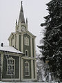 Urjala Church
 -
 Halkivaha Church
 -
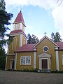 Halkivaha Church
 -
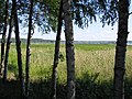 Lake Kortejärvi in Urjala


References[edit]
- ^ a b "Area of Finnish Municipalities 1.1.2018" (PDF). National Land Survey of Finland. Retrieved 30 January 2018.
- ^ a b "Population growth biggest in nearly 70 years". Population structure. Statistics Finland. 2024-04-26. ISSN 1797-5395. Retrieved 2024-04-29.
- ^ "Population growth biggest in nearly 70 years". Population structure. Statistics Finland. 2024-04-26. ISSN 1797-5395. Retrieved 2024-04-29.
- ^ "Population according to age (1-year) and sex by area and the regional division of each statistical reference year, 2003–2020". StatFin. Statistics Finland. Retrieved 2 May 2021.
- ^ a b "Luettelo kuntien ja seurakuntien tuloveroprosenteista vuonna 2023". Tax Administration of Finland. 14 November 2022. Retrieved 7 May 2023.
External links[edit]
![]() Media related to Urjala at Wikimedia Commons
Media related to Urjala at Wikimedia Commons
- Municipality of Urjala – Official website
- Urjalafoorumi – A discussion forum concerning Urjala
Places adjacent to Urjala | |
|---|---|
| Municipalities |  | |
|---|---|---|
| Former municipalities | ||
| International | |
|---|---|
| National | |
| Geographic | |
This Western Finland location article is a stub. You can help Wikipedia by expanding it. |