Egeria, West Virginia: Difference between revisions
Appearance
Content deleted Content added
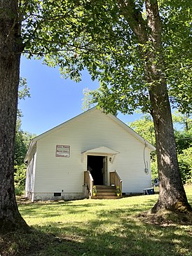
Added photo of one of the few notable buildings in Egeria. |
m I've looked in LOC newspapers, Google Books, Wikipedia Library, NYT, Google, and this is just a real small spot in rural West Virginia. I think this article is about as much as there will be, absent new developments. Removing stub tags. |
||
| Line 94: | Line 94: | ||
[[Category:Unincorporated communities in Raleigh County, West Virginia]] |
[[Category:Unincorporated communities in Raleigh County, West Virginia]] |
||
[[Category:Unincorporated communities in West Virginia]] |
[[Category:Unincorporated communities in West Virginia]] |
||
{{MercerCountyWV-geo-stub}} |
|||
{{RaleighCountyWV-geo-stub}} |
|||
Revision as of 14:09, 30 July 2022
Egeria, West Virginia | |
|---|---|
| Coordinates: 37°32′21″N 81°12′00″W / 37.53917°N 81.20000°W | |
| Country | United States |
| State | West Virginia |
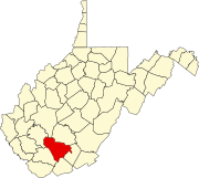
| Counties | Mercer and Raleigh |
| Elevation | 2,972 ft (906 m) |
| Time zone | UTC-5 (Eastern (EST)) |
| • Summer (DST) | UTC-4 (EDT) |
| Area code(s) | 304 & 681 |
| GNIS feature ID | 1549668[1] |

Egeria is an unincorporated community in Mercer and Raleigh counties, West Virginia, United States. Egeria is 8.5 miles (13.7 km) north-northeast of Matoaka. The 1881 guide to the Chesapeake and Ohio Railway lists a blacksmith, two cabinetmakers or undertakers, a general store, a machinist, corn or flour mill, sawmill, and nine "principal farmers".[2]
References
- ^ U.S. Geological Survey Geographic Names Information System: Egeria, West Virginia
- ^ Chataigne, J. H., ed. (1881). Chesapeake & Ohio Railway Directory, Containing an Illustrated History and Description of the Road, Together With Improvements and Connections Already Completed and those in Contemplation; …. Chesapeake & Ohio Railway. Retrieved 18 July 2022.


