Esmeraldas Province: Difference between revisions
Appearance
Content deleted Content added
Iridescent 2 (talk | contribs) m →Cantons: Cleanup and typo fixing, typo(s) fixed: km² → km<sup>2</sup> (2) |
Adding details to esmeraldas Tags: Reverted Mobile edit Mobile web edit |
||
| Line 81: | Line 81: | ||
'''Esmeraldas''' ({{IPA-es|ezmeˈɾaldas}}) is a [[Provinces of Ecuador|province]] in northwestern [[Ecuador]]. The capital is [[Esmeraldas, Ecuador|Esmeraldas]]. |
'''Esmeraldas''' ({{IPA-es|ezmeˈɾaldas}}) is a [[Provinces of Ecuador|province]] in northwestern [[Ecuador]]. The capital is [[Esmeraldas, Ecuador|Esmeraldas]]. |
||
The province is home to the [[Afro-Ecuadorian people|Afro-Ecuadorian culture]]. |
The province is home to the [[Afro-Ecuadorian people|Afro-Ecuadorian culture]]. Esmeraldas is known for their [[petroleum]] and [[wood]] industries as well as for their touristic attractions across the province coastline. |
||
{{stack|[[File:Peñón de Sua Ecuador.JPG|thumb|The Rock of Sua]]}} |
{{stack|[[File:Peñón de Sua Ecuador.JPG|thumb|The Rock of Sua]]}} |
||
Revision as of 15:46, 18 November 2021
Esmeraldas | |
|---|---|
Province | |
| Province of Esmeraldas | |
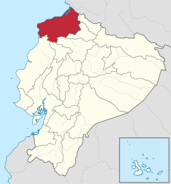
 Location within Ecuador | |
 Cantons of Esmeraldas Province | |
| Coordinates: 0°58′00″S 79°39′00″W / 0.966667°S 79.65°W | |
| Country | Ecuador |
| Established | September 21, 1526 |
| Capital | Esmeraldas |
| Cantons | List of Cantons |
| Government | |
| • Provincial Prefect | Linder Altafuya (MUP) |
| Area | |
| • Total | 16,132.23 km2 (6,228.69 sq mi) |
| Population (2010 census) | |
| • Total | 534,092 |
| • Density | 33/km2 (86/sq mi) |
| Vehicle registration | E |
| HDI (2017) | 0.718[1] high · 16th |
Esmeraldas (Spanish pronunciation: [ezmeˈɾaldas]) is a province in northwestern Ecuador. The capital is Esmeraldas.
The province is home to the Afro-Ecuadorian culture. Esmeraldas is known for their petroleum and wood industries as well as for their touristic attractions across the province coastline.
Demographics
Ethnic groups as of the Ecuadorian census of 2010:[2]
- Mestizo 44.7%
- Afro-Ecuadorian 43.9%
- White 5.9%
- Indigenous 2.8%
- Montubio 2.4%
- Other 0.3%
Cantons
The province is divided into 7 cantons. The following table lists each with its population at the time of the 2001 census, its area in square kilometres (km2), and the name of the canton seat or capital.[3]
| Canton | Pop. (2019) | Area (km2) | Seat/Capital |
|---|---|---|---|
| Atacames | 54,200 | 511 | Atacames |
| Eloy Alfaro | 45,270 | 4,302 | Valdez (a.k.a. Limones) |
| Esmeraldas | 216,900 | 1,351 | Esmeraldas |
| Muisne | 31,030 | 1,265 | Muisne |
| Quinindé | 144,200 | 3,855 | Rosa Zárate (a.k.a. Quinindé) |
| Río Verde | 31,160 | 1,506 | Rioverde |
| San Lorenzo | 60,660 | 3,106 | San Lorenzo |
Parroquias (Parishes)
The cantons are divided into many parroquias:
In Muisne:
See also
References
Wikimedia Commons has media related to Esmeraldas Province.
- ^ Villalba, Juan. "Human Development Index in Ecuador". Scribd (in Spanish). Retrieved 2019-02-05.
- ^ Instituto Nacional de Estadística y Censos. "Resultados |". Ecuadorencifras.gob.ec. Retrieved 2018-12-24.
- ^ Cantons of Ecuador. Statoids.com. Retrieved 4 November 2009.


