Argina, Armenia: Difference between revisions
Appearance
Content deleted Content added
rm COAF spam and unsourced text |
Preacher lad (talk | contribs) mNo edit summary |
||
| Line 20: | Line 20: | ||
|timezone = |
|timezone = |
||
|utc_offset = +4 |
|utc_offset = +4 |
||
|timezone_DST = |
|timezone_DST = |
||
|utc_offset_DST = |
|utc_offset_DST = |
||
|coordinates = {{coord|40|15|N|43|42|E|region:AM|display=inline}} |
|coordinates = {{coord|40|15|N|43|42|E|region:AM|display=inline}} |
||
|elevation_m = |
|elevation_m = |
||
| Line 27: | Line 27: | ||
|website = |
|website = |
||
}} |
}} |
||
'''Argina''' ({{lang-hy|Արգինա}}) is a |
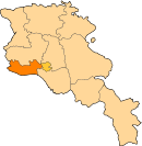
'''Argina''' ({{lang-hy|Արգինա}}) is a village in the [[Armavir Province]] of [[Armenia]]. The town was named after the [[Argina Monastery]], which is across the border in [[Turkey]]. |
||
== See also == |
== See also == |
||
Latest revision as of 06:34, 13 January 2022
40°15′N 43°42′E / 40.250°N 43.700°E
Argina
Արգինա | |
|---|---|
| Coordinates: 40°15′N 43°42′E / 40.250°N 43.700°E | |
| Country | Armenia |
| Marz (Province) | Armavir |
| Population (2001) | |
| • Total | 547 |
| Time zone | UTC+4 ( ) |
Argina (Armenian: Արգինա) is a village in the Armavir Province of Armenia. The town was named after the Argina Monastery, which is across the border in Turkey.
See also[edit]
References[edit]
- Report of the results of the 2001 Armenian Census, Statistical Committee of Armenia
- Kiesling, Brady (June 2000). Rediscovering Armenia: An Archaeological/Touristic Gazetteer and Map Set for the Historical Monuments of Armenia (PDF). Archived (PDF) from the original on 6 November 2021.


