
Fog: Difference between revisions
| Line 115: | Line 115: | ||
*[http://www.weather.gov/wwamap/wwatxtget.php?cwa=usa&wwa=dense%20fog%20advisory United States' current dense fog advisories] from [[NOAA]] |
*[http://www.weather.gov/wwamap/wwatxtget.php?cwa=usa&wwa=dense%20fog%20advisory United States' current dense fog advisories] from [[NOAA]] |
||
*[http://www.wrh.noaa.gov/satellite/ Current Western US fog satellite pictures from NOAA] |
*[http://www.wrh.noaa.gov/satellite/ Current Western US fog satellite pictures from NOAA] |
||
*[http://www.youtube.com/watch?v=r8FPWRj_TKo Lake Ontario Evaporative-Steam Fog Video] |
|||
[[Category:Fog| ]] |
[[Category:Fog| ]] |
||
[[Category:Psychrometrics]] |
[[Category:Psychrometrics]] |
||
Revision as of 01:46, 31 July 2007
- For other meanings, see Fog (disambiguation)
| Part of a series on |
| Weather |
|---|
|
|


Fog is a cloud in contact with the ground. Fog differs from other clouds only in that fog touches the surface of the Earth. The same cloud that is not fog on lower ground may be fog where it contacts higher ground such as hilltops or mountain ridges. Fog is distinct from mist only in its density. Fog is defined as cloud which reduces visibility to less than 1 km, where as mist is that which reduces visibility to less than 2 km.
The foggiest place in the world is the Grand Banks off the island of Newfoundland, Canada. Fog is frequent here as the Grand Banks is the meeting place of the cold Labrador Current from the north and the much warmer Gulf Stream from the south. The foggiest land areas in the world are Point Reyes, California and Argentia, Newfoundland and Labrador, both with over 200 foggy days a year.
Characteristics
Fog forms when water vapor in the air at the surface begins to condense into liquid water. Fog normally occurs at a relative humidity of 100%. This can be achieved by either adding moisture to the air or dropping the ambient air temperature. Fog can form at lower humidities, and fog can sometimes not form with relative humidity at 100%. A reading of 100% relative humidity does not mean that the air can not hold any more moisture, but the air will then becomes known as supersaturated. Fog formation does require all of the elements that normal cloud formation requires with the most important being condensation nuclei. When the air is saturated, additional moisture tends to condense rather than staying in the air as vapor. Condensation nuclei must be present in the form of dust, aeresols, pollutants, etc. for the water to condense upon. When there are exceptional amounts of condensation nuclei present, especially hydroscopic (water seeking such as salt, see below) then the water vapor may condense below 100% relative humidity.
Fog can form suddenly, and can dissipate just as rapidly, depending what side of the dewpoint the temperature is on. This phenomenon is known as Flash Fog and is the inspiration for an antiburglary device that stops burglars by filling the room with artificial fog. [1]
Another type of formation also common is sea fog (also knows as salt fog or salty Fog). This is due to the peculiar effect of salt. Clouds of all types require minute hygroscopic particles upon which water vapor can condense. Over the ocean surface, the most common particles are salt from salt spray produced by breaking waves. Except in areas of storminess, the most common areas of breaking waves are located near coastlines, hence the greatest densities of airborne salt particles are there. Condensation on salt particles has been observed to occur at humidities as low as 70%, thus fog can occur even in relatively dry air in suitable locations such as the California coast. Typically, such lower humidity fog is preceded by a transparent mistiness along the coastline as condensation competes with evaporation, a phenomenon that is typically noticeable by beachgoers in the afternoon.
Fog occasionally produces precipitation in the form of drizzle. Drizzle occurs when the humidity of fog attains 100% and the minute cloud droplets begin to coalesce into larger droplets. This can occur when the fog layer is lifted and cooled sufficiently, or when it is forcibly compressed from above. Drizzle becomes freezing drizzle when the temperature at the surface drops below the freezing point.
The thickness of fog is largely determined by the altitude of the inversion boundary, which in coastal or oceanic locales is also the top of the marine layer, above which the airmass is warmer and drier. The inversion boundary varies its altitude primarily in response to the weight of the air above it which is measured in terms of atmospheric pressure. The marine layer and any fogbank it may contain will be "squashed" when the pressure is high, and conversely, may expand upwards when the pressure above it is lowering.
Fog as a visibility hazard
Fog reduces visibility. Although most sea vessels can penetrate fog using radar, road vehicles have to travel slowly and use low-beam headlights. Localised fog is especially dangerous, as drivers can be caught by surprise.
At airports, some attempts have been made to develop methods (such as using heating or spraying salt particles) to aid fog dispersal. These methods enjoy some success at temperatures below freezing.
Types
This section needs additional citations for verification. (June 2007) |
Fog can form in a number of ways, depending on how the cooling that caused the condensation occurred:
Radiation fog is formed by the cooling of land after sunset by thermal radiation in calm conditions with clear sky. The cool ground produces condensation in the nearby air by heat conduction. In perfect calm the fog layer can be less than a metre deep but turbulence can promote a thicker layer. Radiation fogs occur at night, and usually do not last long after sunrise. Radiation fog is common in autumn, and early winter. Examples of this phenomenon include the Tule fog.
Ground fog is fog that obscures less than 60% of the sky and does not extend to the base of any overhead clouds. However, the term is sometimes used to refer to radiation fog.
Advection fog occurs when moist air passes over a cool surface by advection (wind) and is cooled. It is common as a warm front passes over an area with significant snowpack. It's most common at sea when tropical air encounters cooler waters, or in areas of upwelling, such as along the California coast. The advection of fog along the California coastline is propelled onto land by one of several processes. A cold front can push the marine layer coastward, an occurrence most typical in the spring or late fall. During the summer months, a low pressure trough produced by intense heating inland creates a strong pressure gradient, drawing in the dense marine layer. Also during the summer, strong high pressure aloft over the desert southwest, usually in connection with the summer monsoon, produces a south to southeasterly flow which can drive the offshore marine layer up the coastline, a phenomenon known as a "southerly surge", typically following a coastal heat spell. However, if the monsoonal flow is sufficiently turbulent, it might instead break up the marine layer and any fog it may contain.
Steam fog, also called evaporation fog, is the most localized form and is created by cold air passing over much warmer water or moist land. It often causes freezing fog, or sometimes hoar frost.
Precipitation fog (or frontal fog) forms as precipitation falls into drier air below the cloud, the liquid droplets evaporate into water vapor. The water vapor cools and at the dewpoint it condenses and fog forms.
Upslope fog forms when winds blow air up a slope (called orographic lift), adiabatical cooling it as it rises, and causing the moisture in it to condense. This often causes freezing fog on mountaintops, where the cloud ceiling would not otherwise be low enough.
Valley fog forms in mountain valleys, often during winter. It is the result of a temperature inversion caused by heavier cold air settling into in a valley, with warmer air passing over the mountains above. It is essentially radiation fog confined by local topography, and can last for several days in calm conditions. In California's Central Valley, Valley fog is often referred to as Tule fog.
Ice fog is any kind of fog where the droplets have frozen into extremely tiny crystals of ice in midair. Generally this requires temperatures at or below −35 °C (−30 °F), making it common only in and near the Arctic and Antarctic regions. It is most often seen in urban areas where it is created by the freezing of water vapor present in automobile exhaust and combustion products from heating and power generation. Urban ice fog can become extremely dense and will persist day and night until the temperature rises. Extremely small amounts of ice fog falling from the sky form a type of precipitation called ice crystals, often reported in Barrow, Alaska. Ice fog often leads to the visual phenomenon of light pillars.
Freezing fog occurs when liquid fog droplets freeze to surfaces, forming white rime ice. This is very common on mountain tops which are exposed to low clouds. It is equivalent to freezing rain, and essentially the same as the ice that forms inside a freezer which is not of the "frostless" or "frost-free" type.
Artificial fog is artificially generated fog that is usually created by vaporizing a water and glycol-based or glycerine-based fluid. The fluid is injected into a heated block, and evaporates quickly. The resulting pressure forces the vapor out of the exit. Upon coming into contact with cool outside air the vapor forms a fog - see fog machine.
Garua fog is a type of fog which occurs at the western coast of Chile. The normal fog produced by the sea travels inland, but suddenly meets an area of hot air. This causes the water particles of fog to shrink by evaporation, producing a transparent mist. Garua fog is nearly invisible, yet it still forces drivers to use windshield wipers.
Hail fog sometimes occurs in the vicinity of significant hail accumulations due to increased temperature and increased moisture leading to saturation in a shallow layer near the surface.
Images
Fog shadows
These fascinating shadows look odd since humans are not used to seeing shadows in three dimensions. The thin fog was just dense enough to be illuminated by the light that passed through the gaps in a structure or in a tree. As a result, the path of an object shadow through the "fog" appears darkened. In a sense, these shadow lanes are similar to crepuscular rays, which are caused by cloud shadows, but here, they're caused by an object shadows.
-
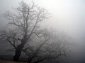
 Fog Shadow of a tree
 -
 Fog Shadow of Sutro Tower
 -
 Fog Shadow of Sutro Tower
 -
 Fog Shadow of the South Tower of the Golden Gate Bridge


Other images
-
 Fog on a Greek mountain.
 -
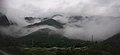 During the rainy season, Japan's mountainscapes are often dominated by fog, as seen here along the Kiso Valley.
 -
 Road traffic in dense fog
 -
 Radiation fog near Wolfenschiessen, Switzerland
 -
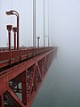 Advection fog at the Golden Gate Bridge in San Francisco Bay.
 -
 Fog obscures a cruise ship and cranes in harbour, App. 30 °C Saint John, New Brunswick.
 -
 Upslope fog curling around the peaks of Mt. Lushan
 -
 Valley fog forms in valleys, often during winter
 -
 Ice fog over Fairbanks, Alaska in winter. Temperature approximately minus 30F.
 -
Artificial fog simulates the result of a weather system malfunction
-
 Fog in San Francisco
 -
 Sutro Tower,San Francisco in fog
 -
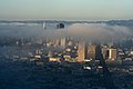 The view of downtown San Francisco from Twin Peaks.
 -
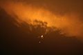
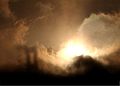
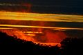 A foggy sunset in San Francisco
 -
 A foggy sunset in San Francisco
 -

-
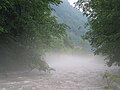
eerie effect of fog over a lake


Accidents
Fog contributes to accidents, particularly with modes of transportation. Ships, trains, cars and planes cannot see each other and collide.
See also
References
Maria K. Filonczuk, Daniel R. Cayan, Laurence G. Riddle, Variability of marine fog along the California coast, SIO-Reference, No 95-2, Climate Research Division, Scripps Institution of Oceanography, University of California San Diego, July 1995.
See also
- Automotive lighting
- Foglamp
- Mist
- Pogonip (weather)
- Smog
- Tule fog
- Camanchacas
- Fogging (photography), blurring artifacts in photography
- Anti-fog against fogging of surfaces