
Douro: Difference between revisions
m robot Adding: ro:Duero |
No edit summary |
||
| Line 25: | Line 25: | ||
| length = 897 |
| length = 897 |
||
| watershed = |
| watershed = |
||
| discharge_location = |
| discharge_location = Porto |
||
| discharge_average = |
| discharge_average = 714 |
||
| discharge_max = |
| discharge_max = 17000 |
||
| discharge_min = |
| discharge_min = |
||
| discharge1_location = |
| discharge1_location = Pocinho |
||
| discharge1_average = |
| discharge1_average = 442 |
||
<!-- *** Source *** --> |
<!-- *** Source *** --> |
||
| source_name = |
| source_name = |
||
| Line 91: | Line 91: | ||
Once the Douro enters Portugal, major population centres are less frequent. Except for [[Porto]] and [[Vila Nova de Gaia]], at the river mouth, the only population centres of any note are [[Foz do Tua]], [[Pinhão]] and [[Peso da Régua]]. Tributaries are small and flow into canyons to enter the larger river. The most important are the [[Côa]], the [[Tua]],the [[Sabor]] ,the [[Corgo]] ,the [[Tavora]],[[Paiva]],the [[Tâmega]] and the [[Sousa]]. None of these small, fast flowing rivers are navigable. |
Once the Douro enters Portugal, major population centres are less frequent. Except for [[Porto]] and [[Vila Nova de Gaia]], at the river mouth, the only population centres of any note are [[Foz do Tua]], [[Pinhão]] and [[Peso da Régua]]. Tributaries are small and flow into canyons to enter the larger river. The most important are the [[Côa]], the [[Tua]],the [[Sabor]] ,the [[Corgo]] ,the [[Tavora]],[[Paiva]],the [[Tâmega]] and the [[Sousa]]. None of these small, fast flowing rivers are navigable. |
||
The Douro vinhateiro,an area of the [[Douro Valley]] in Portugal was classified by UNESCO as a World Heritage Patrimony Sight. |
The Douro vinhateiro,an area of the [[Douro Valley]] in Portugal was classified by UNESCO as a World Heritage Patrimony Sight. |
||
| ⚫ | |||
These reaches of the Douro have a [[microclimate]] allowing for cultivation of [[olive]]s, [[almond]]s, and especially [[grape]]s important for making the famous [[Port wine]]. The region around [[Pinhão]] and [[São João da Pesqueira]] is considered to be the centre of Port wine, with its picturesque ''quintas'' or farms clinging on to almost vertical slopes dropping down to the river. Many of these ''quintas'' are owned by multinational wine companies and are worth a visit. |
These reaches of the Douro have a [[microclimate]] allowing for cultivation of [[olive]]s, [[almond]]s, and especially [[grape]]s important for making the famous [[Port wine]]. The region around [[Pinhão]] and [[São João da Pesqueira]] is considered to be the centre of Port wine, with its picturesque ''quintas'' or farms clinging on to almost vertical slopes dropping down to the river. Many of these ''quintas'' are owned by multinational wine companies and are worth a visit. |
||
Traditionally, the wine was taken down river in flat-bottom boats called ''rabelos'', to be stored in barrels in cellars in [[Vila Nova de Gaia]], just across the river from [[Porto]]. In the 1950s and 1960s [[dam]]s were built along the river ending this river traffic |
Traditionally, the wine was taken down river in flat-bottom boats called ''rabelos'', to be stored in barrels in cellars in [[Vila Nova de Gaia]], just across the river from [[Porto]]. In the 1950s and 1960s [[dam]]s were built along the river ending this river traffic on Spanish and border sections. Now Port wine is transported in tanker trucks. |
||
Recently, a prosperous [[tourism|tourist]] industry has developed based on river excursions from Porto to points along the Upper Douro valley. Boats pass through the dams by way of [[canal lock|locks]]. |
There are five dams on the Portuguese Douro alone making the flow of water uniform, generating [[hydroelectric power]] and allowing navigation. Ships with maximum length 83 m and width 11.4 m can pass through five locks. The highest one on Carrapatelo dam has a maximum lift 35 meters. Level of Pocinho lake reaches 125 m a.s.l. Recently, a prosperous [[tourism|tourist]] industry has developed based on river excursions from Porto to points along the Upper Douro valley. Boats pass through the dams by way of [[canal lock|locks]]. |
||
| ⚫ | |||
In Portugal, the Douro flows through the districts of [[Bragança]], [[Guarda]], [[Viseu]], [[Vila Real]], [[Aveiro]] and [[Porto]]. Porto is the main hub city in northern Portugal and it`s historic centre is declared as a UNESCO monumental place. |
In Portugal, the Douro flows through the districts of [[Bragança]], [[Guarda]], [[Viseu]], [[Vila Real]], [[Aveiro]] and [[Porto]]. Porto is the main hub city in northern Portugal and it`s historic centre is declared as a UNESCO monumental place. |
||
| Line 119: | Line 120: | ||
Image:International Douro view from Miranda.jpg|International Douro near Miranda |
Image:International Douro view from Miranda.jpg|International Douro near Miranda |
||
</gallery> |
</gallery> |
||
==External links== |
|||
* [http://www.douro.iptm.pt/EN/via_navegavel/caracteristicas.aspx IPTM - Instituto Portuário e dos Transportes Marítimos, Delegação do Norte e Douro] |
|||
{{coord|46|08|N|6|33|E|display=title}} |
{{coord|46|08|N|6|33|E|display=title}} |
||
[[Category:Douro basin| ]] |
[[Category:Douro basin| ]] |
||
Revision as of 23:53, 26 February 2009

The Douro or Duero (Latin: Durius, Spanish: Duero, pron. ['dwe̞ɾo̞], Portuguese: Douro, pron. ['doɾu] is one of the major rivers of the Iberian Peninsula, flowing from its source near Duruelo de la Sierra in the province of Soria across northern-central Spain and Portugal to its outlet at Porto. Its total length is 897 km, of which only sections on the Portuguese river are navigable by light rivercraft.
The name may have come from the Celtic tribes that inhabited the area before Roman times. (However, although in modern Welsh dwr is 'water' with cognate "dobhar" in Irish, the Celtic root is *dubro- ).
In its Spanish section, the Duero crosses the great Castilian meseta and meanders through five significant provinces of the autonomous community of Castile and Leon: Soria, Burgos, Valladolid, Zamora, and Salamanca, passing through the towns of Soria, Almazán, Aranda de Duero, Tordesillas, and Zamora.
In this region there are few large tributaries of the Duero. The most important are the Pisuerga, passing through Valladolid, and the Esla, which passes through Benavente. This region, for the most part, is one of semi-arid plains planted with wheat and in some places, especially near Aranda de Duero, in wine grapes, in the Ribera del Duero wine region. Sheep rearing is also still important.
Then, for 112 km, the river forms part of the national border line between Spain and Portugal, in a region of narrow canyons, making it an historical barrier for invasions and a linguistic dividing line. This isolated area has now a protected status: the International Douro Natural Park.
Once the Douro enters Portugal, major population centres are less frequent. Except for Porto and Vila Nova de Gaia, at the river mouth, the only population centres of any note are Foz do Tua, Pinhão and Peso da Régua. Tributaries are small and flow into canyons to enter the larger river. The most important are the Côa, the Tua,the Sabor ,the Corgo ,the Tavora,Paiva,the Tâmega and the Sousa. None of these small, fast flowing rivers are navigable. The Douro vinhateiro,an area of the Douro Valley in Portugal was classified by UNESCO as a World Heritage Patrimony Sight.
These reaches of the Douro have a microclimate allowing for cultivation of olives, almonds, and especially grapes important for making the famous Port wine. The region around Pinhão and São João da Pesqueira is considered to be the centre of Port wine, with its picturesque quintas or farms clinging on to almost vertical slopes dropping down to the river. Many of these quintas are owned by multinational wine companies and are worth a visit.
Traditionally, the wine was taken down river in flat-bottom boats called rabelos, to be stored in barrels in cellars in Vila Nova de Gaia, just across the river from Porto. In the 1950s and 1960s dams were built along the river ending this river traffic on Spanish and border sections. Now Port wine is transported in tanker trucks.
There are five dams on the Portuguese Douro alone making the flow of water uniform, generating hydroelectric power and allowing navigation. Ships with maximum length 83 m and width 11.4 m can pass through five locks. The highest one on Carrapatelo dam has a maximum lift 35 meters. Level of Pocinho lake reaches 125 m a.s.l. Recently, a prosperous tourist industry has developed based on river excursions from Porto to points along the Upper Douro valley. Boats pass through the dams by way of locks.

In Portugal, the Douro flows through the districts of Bragança, Guarda, Viseu, Vila Real, Aveiro and Porto. Porto is the main hub city in northern Portugal and it`s historic centre is declared as a UNESCO monumental place.
The railway Linha do Douro connects Porto, Rio Tinto, Ermesinde, Valongo, Paredes, Penafiel, Livração, Marco de Canaveses, Régua, Tua and Pocinho. Pocinho is near the city of Foz Côa, which is close to Vale Arqueológico do Côa, (an Archaeological pre-historic patrimony) another UNESCO Heritage Sight.
Major riverside towns: Soria, Almazán, Aranda de Duero, Tordesillas, Zamora (Spain); Miranda do Douro, Foz Côa, Peso da Régua (most frequently known as Régua, Lamego, Vila Nova de Gaia, (usually simply known as Gaia) and Porto (Oporto) (Portugal).
The most populous cities along the Douro are Valladolid, Zamora (in Spain) and Porto and Gaia, (in Portugal). The latter two are located at the mouth of the Douro, which is the second largest river in the Iberian Peninsula (The Tagus or Tejo river is the largest in the Iberian Peninsula).
Gallery
-

-
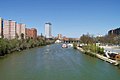 The Pisuerga River (tributary to the Duero) in Valladolid
 -
 The Upper Douro valley where Port wine grapes grow
 -
The typical rabelo boat and Porto historical district in background
-
 The river mouth from Porto's Crystal Palace Gardens, facing west
 -
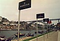 Port wine signs by the river Douro
 -
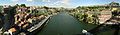
 Panoramic view of Oporto
 -
 The river between Porto and Vila Nova de Gaia
 -

-
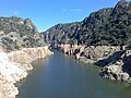 International Douro near Miranda


