
South Padre Island, Texas: Difference between revisions
m Reverted edits by 68.201.111.5 (talk) to last version by Postoak |
See WP:EL. The link contributes NOTHING of encyclopedic value s golf course???. older ≠ wiser 00:27, 13 April 2009 (UTC) |
||
| Line 158: | Line 158: | ||
{{commons|Padre Island}} |
{{commons|Padre Island}} |
||
*[http://www.townspi.com/ Town of South Padre Island] |
*[http://www.townspi.com/ Town of South Padre Island] |
||
*[http://www.sopadre.com/index.php Official Tourism Website for South Padre Island] |
|||
*[http://www.spigolf.com/ South Padre Island Golf Course] |
|||
{{Geolinks-US-cityscale|26.111935|-97.169587}} |
{{Geolinks-US-cityscale|26.111935|-97.169587}} |
||
Revision as of 03:57, 13 April 2009
South Padre Island, Texas | |
|---|---|
 Location of South Padre Island, Texas | |
 | |
| Country | United States |
| State | Texas |
| County | Cameron |
| Area | |
| • Total | 1.9 sq mi (4.9 km2) |
| • Land | 1.8 sq mi (4.7 km2) |
| • Water | 0.1 sq mi (0.2 km2) |
| Elevation | 7 ft (2 m) |
| Population (2000) | |
| • Total | 2,422 |
| • Density | 1,335.9/sq mi (515.8/km2) |
| Time zone | UTC-6 (Central (CST)) |
| • Summer (DST) | UTC-5 (CDT) |
| ZIP code | 78597 |
| Area code | 956 |
| FIPS code | 48-69140Template:GR |
| GNIS feature ID | 1376223Template:GR |
South Padre Island is a town in Cameron County, Texas, United States.[1] It is part of the Brownsville–Harlingen Metropolitan Statistical Area. The population was 2,422 at the 2000 census. Many residents of other parts of the Rio Grande Valley or of Nuevo Leon maintain vacation properties in the town.[citation needed] The town is located on South Padre Island, a barrier island along the Texas Gulf coast assessible via a causeway from the town of Port Isabel. South Padre Island is named after José Nicolás Ballí (Padre Ballí), a Catholic priest and settler. [2]
History
In September 1967, Hurricane Beulah caused extensive damage to much of the town of South Padre Island. [3][4] On July 23, 2008, Hurricane Dolly made landfall on the island as a category 2 storm, also causing extensive damage to the town.
Industry
Subsequent to rebuilding from Hurricane Beulah, the island became a popular spring break destination for college students and other tourists. Many multistory resort hotels and condominiums have been erected along the coastline to the Gulf of Mexico. The Schlitterbahn Beach Waterpark, the second of its kind in Texas, opened in South Padre Island in 2001. [5]
The South Padre International Music Festival is an annual event that occurs the first weekend of November. 2007 marked the inaugural year of the event and was attended by almost 10,000 festival-goers throughout the weekend. Sixty-four bands across fourteen venues filled the island and rocked to an array of both national and international acts, ranging from country, reggae, rock, and indie jams to Latin rock, ska and jazz. [6]
Recreation
South Padre is home to many watersport activities with PWC rental and dolphin watches being the most popular. Other favorites are horseback riding adventures on the beach and ecological tours that explore Padre Island National Seashore.
Fishing is also popular. Also, every year the Texas International Fishing Tournament is held in late summer with winnings totalling almost a quarter million. Along with many other fishing tournaments such as Ladies Kingfish Tournament, Hooters Tournament, Redfish Rodeo just to name a few.
The island is a popular spring break destination for high school and college students.
Geography
South Padre Island is located at 26°6′43″N 97°10′11″W / 26.11194°N 97.16972°WInvalid arguments have been passed to the {{#coordinates:}} function (26.111935, -97.169587)Template:GR.
According to the United States Census Bureau, the town has a total area of 1.9 square miles (4.9 km²), of which, 1.8 square miles (4.7 km²) of it is land and 0.1 square miles (0.2 km²) of it (4.23%) is water.
Climate
South Padre Island experiences a humid subtropical climate, similar to that of the Tampa Bay Area of Florida but with less precipitation and slightly higher summer maximum temperatures. The average high in January is 67 °F (19 °C) and the average low is 52 °F (11 °C). The average high in July is 95 °F (35 °C), and the average low is 77 °F (25 °C). The warm season is long, as average high temperatures are 90-99 °F °C (32-37) , and average low temperatures typically around 77 °F (25 °C). The region experiences relatively high dew point values, around 75 °F (24 °C) in the summer time, resulting in higher relative humidity values from June through September.
Demographics
As of the censusTemplate:GR of 2000, there were 2,422 people, 1,211 households, and 662 families residing in the town. The population density was 1,335.9 people per square mile (516.7/km²). There were 4,685 housing units at an average density of 2,584.1/sq mi (999.4/km²). The racial makeup of the town was 94.59% White, 0.70% African American, 0.45% Native American, 0.21% Asian, 0.04% Pacific Islander, 2.77% from other races, and 1.24% from two or more races. 22.83% of the population is Hispanic or Latino of any race.
There were 1,211 households out of which 15.4% had children under the age of 18 living with them, 47.2% were married couples living together, 4.2% had a female householder with no husband present, and 45.3% were non-families. 35.8% of all households were made up of individuals and 7.8% had someone living alone who was 65 years of age or older. The average household size was 2.00 and the average family size was 2.54.
In the town the population was spread out with 12.9% under the age of 18, 6.2% from 18 to 24, 28.2% from 25 to 44, 34.2% from 45 to 64, and 18.4% who were 65 years of age or older. The median age was 47 years. For every 100 females there were 113.8 males. For every 100 females age 18 and over, there were 115.9 males.
The median income for a household in the town was $45,417, and the median income for a family was $53,250. Males had a median income of $39,250 versus $30,028 for females. The per capita income for the town was $31,708. About 10.2% of families and 12.0% of the population were below the poverty line, including 11.1% of those under age 18 and 7.8% of those age 65 or over.
Education
Children living in South Padre Island are zoned to schools in Port Isabel Independent School District. Children go to Garriga Elementary School (Grades K-2), Derry Elementary School, (3-5), Port Isabel Junior High School (6-8), and Port Isabel High School (9-12). All of the schools are in Port Isabel. [7]
In addition, South Padre Island residents may apply to schools in the South Texas Independent School District. [8]
Transportation
Brownsville/South Padre Island International Airport in Brownsville and Valley International Airport in Harlingen serve the island.[9]
Radio stations
- KFRQ 94.5FM - Official Site
- KKPS 99.5FM - Official Site
- KNVO 101.1FM - Official Site
- KVLY 107.9FM - Official Site
- KTEX 100.3FM - Official Site
Gallery
-
 A west-facing view from the Holiday Inn SunSpree in South Padre Island.
 -
 A street in SPI with residences and condominiums.
 -
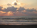 A person taking an early morning walk on the Gulf side of the island.
 -
 This walkway provides access to the beach from a condo.
 -
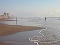 A beach in South Padre Island.
 -
 One of the smaller venues for the South Padre International Music Festival.


References
- ^ Handbook of Texas Online article for South Padre Island Accessed May 17, 2007.
- ^ Handbook of Texas Online biography of José Nicolás Ballí Accessed May 16, 2007.
- ^ Handbook of Texas Online article on hurricanes in Texas Accessed May 16, 2007.
- ^ Padre Island's history with tropical systems Accessed May 17, 2007.
- ^ Background information on Schlitterbahn developments in Texas Accessed May 16, 2007.
- ^ About the festival Accessed March 26, 2008.
- ^ Port Isabel ISD Accessed May 16, 2007.
- ^ South Texas Independent School District Accessed May 16, 2007.
- ^ "Southwest Airlines Cities," Southwest Airlines
External links
Template:Geolinks-US-cityscale
