
São Miguel Island: Difference between revisions
No edit summary |
→Famous people from São Miguel: Removed Nelly Furtado : she is from Canada |
||
| Line 57: | Line 57: | ||
==Famous people from São Miguel== |
==Famous people from São Miguel== |
||
* [[Nelly Furtado]], song artist |
|||
* [[Suzana Da Camara]], song artist |
* [[Suzana Da Camara]], song artist |
||
* Pedro Pauleta, football player |
* Pedro Pauleta, football player |
||
Revision as of 01:23, 27 April 2009
Nickname: The Green Island | |
|---|---|
 | |
| Geography | |
| Location | Atlantic Ocean |
| Coordinates | 37°47′N 25°30′W / 37.783°N 25.500°W |
| Archipelago | Azores Islands |
| Administration | |
Portugal | |
| Demographics | |
| Population | 140,000 |
São Miguel Island (pron. IPA: [sɐ͠u miˈɡɛɫ]; Portuguese for Saint Michael), nicknamed "The Green Island", is the largest and most populous of the Azores Islands archipelago. The island covers 759 km2 (293 sq mi) and has around 140,000 inhabitants (called Micaelenses); the largest town is Ponta Delgada, with about 45,000 inhabitants.
Geography
São Miguel is 64 km from east to west, and between 8 and 14 km wide. Named the "Green (Verde) Island", São Miguel is largely covered with fields and meadows in the lowlands. The ancient laurisilva forest has been mostly replaced by exotic vegetation. Some hot springs (caldeiras) appear mostly in the center of the island, which is composed of an old solid mass that stretches from Povoação to Nordeste. São Miguel has three stratovolcanoes and caldeiras, Sete Cidades, Agua de Pau, Caldeiras and finally Furnas. The volcanic masses are connected between the alignments of the cone-like mass that are made up of peaks.
The peak area between Sete Cidades and Fogo is a monogenetic volcanic field composed of 270 volcanoes. They are primarily made up of basaltic cones which were formed during Strombolian and Hawaiian-style eruptions. It is the most recently active area of the island. The youngest volcanoes are relatively well dated. It is possible to count 19 eruptions which have occurred 3,000 years ago. Several eruptions were historical, although the last happened in the seventeenth century. The most famous of these is known as Fogo 2, it occurred in 1652.
The highest elevation on São Miguel is the Pico da Vara at 1,103 m.
Cities
Municipalities
Famous people from São Miguel
- Suzana Da Camara, song artist
- Pedro Pauleta, football player
History
São Miguel was the second of the Azores islands to have a Portuguese settlement in 1427.
15th century
It is believed that the island was discovered between 1426 and 1439 being already marked in portolans, in the middle of the fourteenth century, as “Green Island”. The populace began in 1439, when Henry the Navigator, by Carta-Régia (name of the king’s letter that had been written to the authorities or the authority and that its contents had often general and permanent determinations), authorized the fixation of settlers coming from Estremadura, Alto Alentejo, Algarve, and also Madeira. Some foreigners also had settled on the island, notably French people and cultural minorities such as Jews and Moors.
The geographic position and the soil fertility led to a rapid economic development, based on the primary sector, focused on the political military garrisons supply in the north of Africa and in the production of sugar and orchil, a dye exported to Flandres.
16th century
The first capital of this island was Vila Franca do Campo, which was devastated by a major earthquake in 1522.
After this tragedy, the development of the population of Ponta Delgada gained impetus, becoming the new capital in 1546. In the context of the crises of succession in 1580, the people from São Miguel Island won the Naval Battle of Vila Franca against a French squad that supported the claims of António, Prior of Crato.Then when they least expected, the volcano Fogo 2 erupted, destroying the capital city and causing the death of 250 people.
17th century
With the Restoration of Portuguese Independency (1640), the island regained its position as a commercial center, getting new contacts with Brazil, a place where so many settlers were sent.
18th century
Some of the island’s historic buildings, including mansions and churches, date from this period. This architectural expansion is justified by profits earned from the production of oranges for exportation, whose main market was Great Britain.
19th century
In 1831, after the landing of Liberal troops in Nordeste ordered by the future duke of Terceira, the resistance to the Absolutist regime on the Island was organized. In 1832, the Army, after declaring the Constitution and recognizing Maria II of Portugal as their queen, left Ponta Delgada. After the troubled period of the Liberal Wars, the previous economic expansion resumed, the port of Ponta Delgada was built, and also new crops such as tea, pineapple, and tobacco were introduced.
20th century
The development of the fishing industry and the improvement of agricultural products helped to boost the economy until the present day. Currently, the island is one of the most dynamic political-administrative centers and it is in São Miguel Island where the headquarters of the government of the Azores is.
Gallery
-
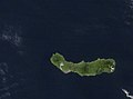 NASA satellite photo (North to the top)
 -
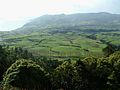 Eastern São Miguel landscape
 -
 Mosteiros, a village on the northwestern coast
 -
 Lagoa Pao Pique, a volcanic crater lake near Sete Cidades
 -
 Caldeira Velha, a waterfall and hot spring near Ribeira Grande, São Miguel
 -
 Between 203 and 331 individuals of the Azores Bullfinch are left on São Miguel


References
- Scarth, Alwyn (2001). Volcanoes of Europe. Oxford University Press. pp. 243 pp. ISBN 0-19-521754-3.
{{cite book}}: Unknown parameter|coauthors=ignored (|author=suggested) (help) - Global Volcanism Program: Azores
- Nelly Furtado's parents migrated from the island to Canada.
- History part done by a student from Gardner-webb University Rita Gouveia in 2008.
References
Suzana da Camara, being grand daughter of Luisa Cristina Da Camara Falcao Correia Da Silva, direct descendent of William the Conquerer of England.
External links
- The Azores Islands - Site with abundant information about São Miguel Island
- São Miguel Island on Google Maps
| Grupo Oriental (Eastern Group) |  | |
|---|---|---|
| Grupo Central (Central Group) | ||
| Grupo Ocidental (Western Group) | ||
| Islets | ||
| Caves and geological features | ||
| Reefs, banks and seamounts | ||