
Talk:2009 swine flu pandemic in the United States: Difference between revisions
ClueBot III (talk | contribs) m Archiving 1 discussion to Talk:2009 swine flu outbreak in the United States/Archive 1. (BOT) |
No edit summary |
||
| Line 48: | Line 48: | ||
{{-}} |
{{-}} |
||
---- |
---- |
||
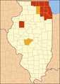
== Missouri == |
|||
<gallery> |
|||
File:H1N1 Missouri map by county.svg|File:H1N1 Missouri map by county.svg |
|||
File:H1N1 Missouri map by county-2009-19-05.svg|File:H1N1 Missouri map by county-2009-19-05.svg |
|||
</gallery> |
|||
The maps have gone out of sync again. AND the "county-2009-19-05.svg" now no longer makes sense, since it was updated on the 22nd. [[Special:Contributions/76.66.196.85|76.66.196.85]] ([[User talk:76.66.196.85|talk]]) 05:43, 23 May 2009 (UTC) |
|||
Revision as of 05:43, 23 May 2009
| This is the talk page for discussing improvements to the 2009 swine flu pandemic in the United States article. This is not a forum for general discussion of the article's subject. |
Article policies
|
| Find medical sources: Source guidelines · PubMed · Cochrane · DOAJ · Gale · OpenMD · ScienceDirect · Springer · Trip · Wiley · TWL |
| Archives: Index, 1, 2Auto-archiving period: 2 days |
| This article is written in American English, which has its own spelling conventions (color, defense, traveled) and some terms that are used in it may be different or absent from other varieties of English. According to the relevant style guide, this should not be changed without broad consensus. |
| This article is of interest to the following WikiProjects: | |||||||||||||||||||||||||||||||||||||||||||||||||||||||||||||||||||||||||||||||
| |||||||||||||||||||||||||||||||||||||||||||||||||||||||||||||||||||||||||||||||


This template must be substituted. Replace {{Requested move ...}} with {{subst:Requested move ...}}.
Error: Target page was not specified with to. |
Error: Target page was not specified with to. |
Error: Target page was not specified with to. |
| Summaries of this article appear in 2009 swine flu outbreak and 2009 swine flu outbreak by country. |
|
This page has archives. Sections older than 2 days may be automatically archived by ClueBot III. |
- Disused maps
-
-


Michigan maps

There are two versions of this map... the one on Commons isn't being updated as the one on English Wikipedia is updated... 76.66.202.139 (talk) 05:10, 21 May 2009 (UTC)
Washington Maps?
Would someone please put a map up for the State of Washington? Since over 500 cases in 17 counties have been confirmed, not to mention one death, I think it would be important to make one. Also, there is a map located at the Washington State Depart of Health's website under swine flu. --98.225.48.221 (talk) 00:24, 23 May 2009 (UTC)
Missouri
-
 File:H1N1 Missouri map by county.svg
 -
 File:H1N1 Missouri map by county-2009-19-05.svg


The maps have gone out of sync again. AND the "county-2009-19-05.svg" now no longer makes sense, since it was updated on the 22nd. 76.66.196.85 (talk) 05:43, 23 May 2009 (UTC)
- Wikipedia articles that use American English
- B-Class medicine articles
- Mid-importance medicine articles
- All WikiProject Medicine pages
- B-Class virus articles
- Unknown-importance virus articles
- WikiProject Viruses articles
- B-Class Disaster management articles
- Unknown-importance Disaster management articles
- B-Class International relations articles
- Unknown-importance International relations articles
- WikiProject International relations articles
- B-Class United States articles
- Unknown-importance United States articles
- B-Class United States articles of Unknown-importance
- WikiProject United States articles
- B-Class Mexico articles
- Unknown-importance Mexico articles
- WikiProject Mexico articles