
South Carolina Highway 31: Difference between revisions
→Exit list: modified exit list table |
|||
| Line 45: | Line 45: | ||
| 0.0 |
| 0.0 |
||
| [[Image:South Carolina 544.svg|25px]] [[South Carolina Highway 544]] – [[Georgetown (SC)|Georgetown]], [[Conway (SC)|Conway]], [[Surfside Beach (SC)|Surfside Beach]] |
| [[Image:South Carolina 544.svg|25px]] [[South Carolina Highway 544]] – [[Georgetown (SC)|Georgetown]], [[Conway (SC)|Conway]], [[Surfside Beach (SC)|Surfside Beach]] |
||
| Southbound exit and northbound entrance |
|||
| Southern terminus |
|||
|- |
|- |
||
|rowspan=2| [[Carolina Forest, South Carolina|Carolina Forest]] |
|rowspan=2| [[Carolina Forest, South Carolina|Carolina Forest]] |
||
| Line 72: | Line 72: | ||
| 26.6 |
| 26.6 |
||
| [[Image:South Carolina 9.svg|25px]] [[South Carolina Highway 9]] – [[Loris, South Carolina|Loris]], [[Dillon, South Carolina|Dillon]]<br>to [[Image:US 17.svg|25px]] [[U.S. Highway 17]] – [[Cherry Grove Beach, South Carolina|Cherry Grove Beach]] |
| [[Image:South Carolina 9.svg|25px]] [[South Carolina Highway 9]] – [[Loris, South Carolina|Loris]], [[Dillon, South Carolina|Dillon]]<br>to [[Image:US 17.svg|25px]] [[U.S. Highway 17]] – [[Cherry Grove Beach, South Carolina|Cherry Grove Beach]] |
||
| Southbound entrance and northbound exit |
|||
| Northern terminus |
|||
|} |
|} |
||
Revision as of 22:47, 18 July 2009
 | |
|---|---|
| Carolina Bays Parkway/John B. Singleton Parkway | |
 | |
| Route information | |
| Maintained by South Carolina Department of Transportation | |
| Length | 24.4 mi (39.3 km) |
| Existed | 2002–present |
| Major junctions | |
| Location | |
| Country | United States |
| State | South Carolina |
| Highway system | |
Carolina Bays Parkway (South Carolina Highway 31, abbreviated S.C. Highway 31 or SC 31) is a six-lane Interstate Highway standards freeway that parallels (in most case) the Intracoastal Waterway from Myrtle Beach, South Carolina. The first phase opened on December 17, 2002, completing a 22-mile (35 km) link between U.S. Route 501 and S.C. Highway 9. The second phase opened in March 2005, running from US 501 southwest to and S.C. Highway 544. While the freeway is colloquially referred to as the Carolina Bays Parkway, the South Carolina General Assembly also designated the highway to be named the John B. Singleton Parkway in April 2000 in memory of John B. Singleton, a former Myrtle Beach City Council member and police commissioner[1].
Phases and future plans
Phase I, the initial phrase from U.S. Route 501 to S.C. Highway 9, was under consideration as early as 1994[2]. Preliminary environmental impact research commenced in 1996[3] and concluded in 1998[4]. Much of the road's path was determined by pre-existing developments and future development plans already put into place from International Paper's Carolina Forest development and Grande Dunes. Between Robert Grissom Parkway and U.S. Route 501, much of the road follows old logging trails.
Phase II was completed in March 2005 and follows a former logging road and a geographic ridge formation. A second bridge was built at the intersection with U.S. Route 501.
Phase III will be completed in the near future, taking it south to U.S. Route 17 Bypass in Surfside Beach at Holmestown Road and S.C. Highway 707. The third phase has been changed several time in compliance with environmental issues concerning the surrounding area. This will be the future terminus of Interstate 74, as funding cannot allow for the possible extensions to Georgetown or Charleston that had once been planned in the early 1990s.
A northern extension is also planned to connect with U.S. Route 17 in North Carolina. This extension would end at the North Carolina state border and closely parallel County Road 57. NCDOT would continue the Carolina Bays Parkway throughout the state as Interstate 74[5].
The Carolina Bays Parkway is planned to become part of Interstate 74, as well as Interstate 73 southwest of the Conway Bypass (S.C. Highway 22). The North Myrtle Beach Connector will run from the Parkway between S.C. Highway 22 and S.C. Highway 9 east to Main Street in North Myrtle Beach. This road, now known as Robert Edge Parkway, should open later in summer 2009.
Exit list
| County | Location | Mile | Destinations | Notes |
|---|---|---|---|---|
| Horry | Socastee | 0.0 | Southbound exit and northbound entrance | |
| Carolina Forest | 4.7 | |||
| 10.5 | Robert Grissom Parkway – Myrtle Beach International Drive – Carolina Forest |
|||
| Myrtle Beach | 15.0 | Water Tower Road | ||
| North Myrtle Beach | 16.5 | |||
| 24.4 | Opening August 2009 | |||
| 26.6 | to |
Southbound entrance and northbound exit |
Photo Gallery
-
 South Carolina 31 at Grissom Parkway going south
 -
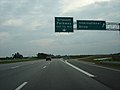
 South Carolina 31 near Conway Bypass
 -
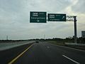 South Carolina 31 at South Carolina 544 the southern terminus


References
- ^ Bill 4466, South Carolina General Assembly, 113th Session, 1999-2000
- ^ Carolina Bays Parkway, South Carolina Department of Transportation, 1994.
- ^ Carolina Bays Parkway, Georgetown and Horry Counties South Carolina : draft environmental impact statement, South Carolina Department of Transportation, 1996.
- ^ Carolina Bays Parkway, Horry County, South Carolina : final environmental impact statement, South Carolina Department of Transportation, 1998.
- ^ NCDOT - Carolina Bays Parkway Extension Feasibility Study