
Lake Wakatipu: Difference between revisions
Ngatimozart (talk | contribs) Added Maori legend. |
Ngatimozart (talk | contribs) No edit summary |
||
| Line 35: | Line 35: | ||
There is an old [[Maori]] legend that the lake has a [[taniwha]] sleeping in it and when the taniwha breathes in the water level drops and when the taniwha breathes out the water level rises. In actuality the lake's seiche referred to above is the reason. |
There is an old [[Maori]] legend that the lake has a [[taniwha]] sleeping in it and when the taniwha breathes in the water level drops and when the taniwha breathes out the water level rises. In actuality the lake's seiche referred to above is the reason. |
||
</ref> |
|||
==In popular culture== |
==In popular culture== |
||
Revision as of 00:13, 2 April 2010
| Lake Wakatipu | |
|---|---|
| Location | Queenstown-Lakes District, Otago Region, South Island |
| Coordinates | 45°3′S 168°30′E / 45.050°S 168.500°E |
| Primary inflows | Dart River |
| Primary outflows | Kawarau River |
| Basin countries | New Zealand |
| Max. length | 80 km |
| Surface area | 291 km² |
| Average depth | 230 Metres |
| Max. depth | 420 Metres |
| Residence time | c. 12 years |
| Surface elevation | 310 m |
| Islands | Pig Island & Pigeon Island |
| Settlements | Kingston, Queenstown, Glenorchy |

Lake Wakatipu is an inland lake (finger lake) in the South Island of New Zealand. It is in the southwest corner of Otago Region, near its boundary with Southland.
With a length of 80 kilometres, it is New Zealand's longest lake, and, at 291 km², its third largest. It is at an altitude of 310 metres, towards the southern end of the Southern Alps. The general topography is a reversed "N" shape. The Dart River flows into the northern end, the lake then runs south for 30 kilometres before turning abruptly to the east. Twenty kilometres further along, it turns sharply to the south, reaching its southern end 30 kilometres further south, near Kingston.
The lake is drained by the Kawarau River, which flows out from the lake's Frankton Arm, 8km east of Queenstown. Queenstown is on the northern shore of the lake close to eastern end of its middle section. The lake is very deep, its floor being as low as 100 metres below sea level. It has a seiche of period 26.7 minutes which, in Queenstown Bay, causes the water level to rise and fall some 200 millimetres.[1]
Lake Wakatipu is renowned for its scenic beauty, being surrounded by mountains. The Remarkables mountain range lies along its southeastern edge. It is a popular venue for adventure tourism, with skifields, paragliding, bungy jumping and tramping tracks within easy reach. A vintage steamboat, the TSS Earnslaw regularly plies its waters. Several vineyards are nearby.
There is an old Maori legend that the lake has a taniwha sleeping in it and when the taniwha breathes in the water level drops and when the taniwha breathes out the water level rises. In actuality the lake's seiche referred to above is the reason.
In popular culture
Lake Wakatipu doubled as the famous Scottish 'Loch Ness' in the 2007 film 'The Water Horse: Legend of the Deep.' Lake Wakatipu has many geographical similarities to 'Loch Ness' and was chosen as one of the main filming locations in the movie.[2]
It was the filming location for the Lothlórien sequences in The Lord of the Rings: The Fellowship of the Ring.
Gallery
-
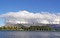
 Northern end
 -
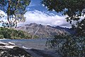 Near Walter Peak
 -
 Lake Wakatipu


-
 Lake Wakatipu & Remarkable Mountains in Queenstown, New Zealand
 -
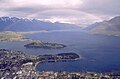
 View from Queenstown heights
 -
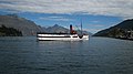 The TSS Earnslaw on Lake Wakatipu in Queenstown


-
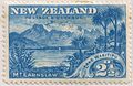 1898 New Zealand stamp with the name mis-spelled as Lake Wakitipu. This was corrected in later printings.
.JPG)
References
- ^ Google Answers:Why does Lake Wakatipu in New Zealand rise and fall?
- ^ Miller, Gerri. "Inside 'The Water Horse'". HowStuffWorks, Inc. Retrieved 2008-07-07.