
Boulevard East: Difference between revisions
wording |
→Transportation: miles correction |
||
| Line 71: | Line 71: | ||
|customcommons= |
|customcommons= |
||
}} |
}} |
||
Boulevard East carries three [[List of county routes in Hudson County, New Jersey|county route]] designations. '''County Route 677'''<ref>{{cite web|url=http://www.state.nj.us/transportation/refdata/sldiag/090006772__-pdf|format=PDF|title=Hudson County 677 II straight line diagram|publisher=[[New Jersey Department of Transportation]]|accessdate=2009-09-14}}</ref> begins as Park Avenue in Hoboken, becoming Boulevard East after crossing the viaduct over the [[Hudson Bergen Light Rail]] tracks. At Highwood Terrace in Weehawken it becomes part of '''[[County Route 505 (New Jersey)|County Route 505]]'''. From 60th Street in [[West New York]] it is designated '''County Route 693'''<ref>{{cite web|url=http://www.state.nj.us/transportation/refdata/sldiag/09000693__-.pdf|format=PDF|title=Hudson County 693 straight line diagram|publisher=[[New Jersey Department of Transportation]]|accessdate=2009-09-44}}</ref><ref>[http://www.state.nj.us/transportation/refdata/.../09000693__-.pdf NJ Transportation data CR693]</ref> until joining its western counterpart, designated '''[[County Route 501 (New Jersey)|County Route 501]]'''. In total the route is slighty more than |
Boulevard East carries three [[List of county routes in Hudson County, New Jersey|county route]] designations. '''County Route 677'''<ref>{{cite web|url=http://www.state.nj.us/transportation/refdata/sldiag/090006772__-pdf|format=PDF|title=Hudson County 677 II straight line diagram|publisher=[[New Jersey Department of Transportation]]|accessdate=2009-09-14}}</ref> begins as Park Avenue in Hoboken, becoming Boulevard East after crossing the viaduct over the [[Hudson Bergen Light Rail]] tracks. At Highwood Terrace in Weehawken it becomes part of '''[[County Route 505 (New Jersey)|County Route 505]]'''. From 60th Street in [[West New York]] it is designated '''County Route 693'''<ref>{{cite web|url=http://www.state.nj.us/transportation/refdata/sldiag/09000693__-.pdf|format=PDF|title=Hudson County 693 straight line diagram|publisher=[[New Jersey Department of Transportation]]|accessdate=2009-09-44}}</ref><ref>[http://www.state.nj.us/transportation/refdata/.../09000693__-.pdf NJ Transportation data CR693]</ref> until joining its western counterpart, designated '''[[County Route 501 (New Jersey)|County Route 501]]'''. In total the route is slighty more than three miles long.<ref>[http://www.freemaptools.com/how-far-is-it-between.htm How far is it between?]</ref> |
||
Addresses ascend from the first at number 300.<ref>[http://www.300-boulevard-east-weehawken.com/ 300 Boulevard East]</ref> In Weehawken the numbers rise to 1055. At the border with West New York at 51st Street, the addresses jump to 5101, following the custom of taking the building number from the lower cross street. This system was jointly adopted by the [[North Hudson, New Jersey|North Hudson]] towns after streets were re-numbered after the opening of the [[Lincoln Tunnel]] in 1937. |
Addresses ascend from the first at number 300.<ref>[http://www.300-boulevard-east-weehawken.com/ 300 Boulevard East]</ref> In Weehawken the numbers rise to 1055. At the border with West New York at 51st Street, the addresses jump to 5101, following the custom of taking the building number from the lower cross street. This system was jointly adopted by the [[North Hudson, New Jersey|North Hudson]] towns after streets were re-numbered after the opening of the [[Lincoln Tunnel]] in 1937. |
||
Revision as of 07:29, 28 May 2010


Boulevard East is a two-way, mostly two lane, scenic thoroughfare in the North Hudson, New Jersey municipalities of Weehawken, West New York, Guttenberg and North Bergen. Apart from small sections at either end, the road runs atop the Hudson Palisades, affording it views of the Hudson River and the New York City skyline. Developed at the turn of the century, the residential road is characterized by an electic mix of 20th century architecture, including private homes as well as mid and high-rise apartment buildings, mostly on its western side, with a promenade and parks along its eastern side.
Name
Boulevard East is so-named in reference to the other major boulevard in Hudson County to which it is connected, Kennedy Boulevard. Prior to being renamed in honor of John F. Kennedy in the 1960s, the street was known as Hudson Boulevard. While there was discussion of building a county long road as early as the 1870s,[1] parts of Hudson County Boulevard were officially opened in 1896.[2]Taken as a single road, the circuitous route of west and east sections of the entire boulevard runs from the southern tip of the county at Bergen Point to its northern border with Bergen County and south again to the Hoboken city line. In local nomenclature, signage, addresses, transportation, and postal delivery the name Boulevard East is used.[3][4][5]
Description
Much of Boulevard East runs parallel to the edge of an sheer escarpment and offers expanisve views the iconographic Manhattan skyline. Its southern end is an important component of local access to the Lincoln Tunnel, running past its Art Deco toll plaza and passing twice under the helix which descends to meet it. Entering a residential district of Weehawken the boulevard steeply ascends until reaching the Boulevard Curve where it begins travelling along the edge of the Hudson Palisades. Just to the south of the curve is the site of Hamilton Memorial, relocated from the Burr-Hamilton duel site at the foot of the cliffs below Kings Bluff, named for the James Gore King whose 19th century estate, Highwood, once stood there, and is now a residential neighborhood. It then passes Hamilton Plaza where for a brief time in the 1890's stood El Dorado, a pleasure garden offering theatrical spectacles, casinos, and exotic gardens. At Liberty Place it crosses over a now defunct cut through which once ran streetcars operated by North Hudson County Railway that connected to a massive elevator and ferries at Weehawken Terminal. Pershing Road is one of the few roads which connects the Boulevard and the top of the cliffs with the waterfront and was once part of the Lincoln Highway.[6] Old Glory Park is near the town line of West New York where of the much boulevard is abutted by parks and scenic overlooks. A statue of Thomas M. Donnelly, instrumental in the preservation of the Palisades, is located in the park named for him. The trap rock walls that line much of the overlook come from quarry operations that he and the NJ Federation of Womens Clubs were able curtail at the beginning of the 20th century.[7] 60th Street, the main crosstown street for the town becames Hillside Road (officially re-named for Anthony DeFino, mayor for more than 24 years [8]) connecting the boulevard to River Road. One of the few residential neighborhoods on the cliff side of the boulevard is found north of the major crossroad as it one of its more severe curves. It is here that the road reaches a height of nearly 260 feet near the highest point in Hudson County.[9] The three block section of the boulevard in Gutenberg is dominated by the Galaxy Towers, a Brutalist trio of octaganal buildings, which rise from the foot of the palisades and soar above them. Ferry Road passes underneath the complex. The Woodcliff Section of North Bergen, once known as Hudson Heights, is characterized by a combination of family homes and modernist high-rises, notably the round Stonehenge. Near the point where the road bears west and enters North Hudson Park the original Bulls Ferry Road makes a steep descent to the east. After passing through the park, also named for famous son James J. Braddock, Boulevard East enters Nungessers at Bergenline.[10]
Transportation
   | |
|---|---|
| JFK Blvd East Hudson Blvd East | |
| Major junctions | |
60th Street & Hillside | |
| Location | |
| Municipalities | Weehawken West New York Gutunberg North Bergen |
Boulevard East carries three county route designations. County Route 677[11] begins as Park Avenue in Hoboken, becoming Boulevard East after crossing the viaduct over the Hudson Bergen Light Rail tracks. At Highwood Terrace in Weehawken it becomes part of County Route 505. From 60th Street in West New York it is designated County Route 693[12][13] until joining its western counterpart, designated County Route 501. In total the route is slighty more than three miles long.[14]
Addresses ascend from the first at number 300.[15] In Weehawken the numbers rise to 1055. At the border with West New York at 51st Street, the addresses jump to 5101, following the custom of taking the building number from the lower cross street. This system was jointly adopted by the North Hudson towns after streets were re-numbered after the opening of the Lincoln Tunnel in 1937.
New Jersey Transit bus routes 128, 165, 166, 168 travel along the boulevard between the Port Authority Bus Terminal and locations in Bergen County. Dollar vans, many of which originate at Nungesser's, also travel along the street to 42nd Street in Manhattan. Pershing Road and public stairs connect the road to Weehawken Port Imperial, where ferries and light rail are available.
Gallery
-
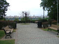 The thoroughfare is lined with many parks and scenic outlooks.
 -
 Bust of Thomas M. Donnelly, whose contributions helped save the Palisades.
 -
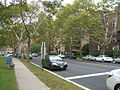
 In West New York at 60th Street, one of the few streets which connects it to the Hudson River waterfront.
 -
 Art-Deco-era apartment buildings and promenade in North Bergen.


References
- ^ New York Times http://query.nytimes.com/mem/archive-free/pdf?_r=1&res=9E0DE5D71F38E333A25751C1A96E9C946290D7CF. Retrieved March 29, 2010.
{{cite journal}}: Cite has empty unknown parameter:|coauthors=(help); Italic or bold markup not allowed in:|journal=(help); Missing or empty|title=(help) - ^ New York Times http://query.nytimes.comgst/abstract.html?res=9D06E2D81E3AE533A25753C3A96E9C94679ED7CF. Retrieved March 26, 2010.
{{cite journal}}: Cite has empty unknown parameter:|coauthors=(help); Missing or empty|title=(help) - ^ Review of Boulevard East
- ^ 07086 USPS Box
- ^ JFK Blvd East, commonly known as Blvd East
- ^ Sherman, Lauren; Gaulkin, Ellen Robb (2009). [[http.//www.arcadiapublishing.com] Weehawken] (paper). Images of America (1st ed.). Arcadia Publishing. ISBN 13978-0-73855-6268-1.
{{cite book}}: Check|isbn=value: length (help); Check|url=value (help); Cite has empty unknown parameters:|laydate=,|separator=,|trans_title=,|trans_chapter=,|laysummary=,|chapterurl=, and|lastauthoramp=(help); Unknown parameter|month=ignored (help) - ^ Hague, Jim (Nov 15, 2002). "Saving the Palisades Documentary, shown at Weehawken Public Library, portrays women's role in preserving cliffs". Hudson Reporter.
{{cite journal}}: Cite has empty unknown parameter:|coauthors=(help) - ^ http://www.nj.com/hudson/index.ssf/2009/01/late_west_new_york_mayor_induc.html
- ^ Hudson High Point
- ^ Hudson County New Jersey Street Map. Hagstrom Map Company, Inc. 2008. ISBN 0-8809-7763-9.
- ^ "Hudson County 677 II straight line diagram" (PDF). New Jersey Department of Transportation. Retrieved 2009-09-14.
- ^ "Hudson County 693 straight line diagram" (PDF). New Jersey Department of Transportation. Retrieved 2009-09-44.
{{cite web}}: Check date values in:|accessdate=(help) - ^ NJ Transportation data CR693
- ^ How far is it between?
- ^ 300 Boulevard East