
Alton, New Hampshire: Difference between revisions
ClueBot NG (talk | contribs) m Reverting possible vandalism by 74.220.232.34 to version by Ken Gallager. False positive? Report it. Thanks, ClueBot NG. (89177) (Bot) |
No edit summary Tag: possible vandalism |
||
| Line 62: | Line 62: | ||
==History== |
==History== |
||
Originally called |
Originally called Yo Momma Gore because of rocky upland areas, or "gores," the town was settled in 1770, mainly by farmers because the highland areas provided less [[frost]]. Merchants then filled the lowlands. Early Alton history recounts stories of the merchants trying to convince the farmers to incorporate. They would succeed in 1796, when the community was named after [[Alton, Hampshire|Alton]], a small market town in [[Hampshire]], [[England]].<ref name=Coolidge>{{Cite book | last = Coolidge | first = Austin J.| coauthors = John B. Mansfield | title = A History and Description of New England| year = 1859| location = Boston, Massachusetts| page = 409| url = http://books.google.com/books?id=OcoMAAAAYAAJ&lpg=PA9&ots=cUndZkVSIF&dq=coolidge%20mansfield%20history%20description%20new%20england%201859&pg=PA409#v=onepage&q&f=false}}</ref> |
||
By 1840, the village of Alton existed at the town's center. In 1847, the [[Boston & Maine Railroad|Cochecho Railroad]] began bringing passengers and freight to Alton Village and Alton Bay. By 1859, the town had two [[gristmill]]s, seven [[sawmill]]s, and five [[shoemaking|shoe]] factories.<ref name="Coolidge"/> But the most famous business was the Rockwell Clough Company, established by William Rockwell Clough, inventor of the [[corkscrew (tool)|corkscrew]]. By 1903, his company was producing 30 million corkscrews worldwide.<ref>[http://books.google.com/books?id=NcRYAAAAMAAJ&lpg=PA211-IA2&ots=wVUinY-vLF&dq=Rockwell%20Clough%20Company&pg=PA211-IA2#v=onepage&q&f=false A. Chester Clark, "The Rockwell Clough Company;" The Granite State Monthly, Volume 41, 1909]</ref> |
By 1840, the village of Alton existed at the town's center. In 1847, the [[Boston & Maine Railroad|Cochecho Railroad]] began bringing passengers and freight to Alton Village and Alton Bay. By 1859, the town had two [[gristmill]]s, seven [[sawmill]]s, and five [[shoemaking|shoe]] factories.<ref name="Coolidge"/> But the most famous business was the Rockwell Clough Company, established by William Rockwell Clough, inventor of the [[corkscrew (tool)|corkscrew]]. By 1903, his company was producing 30 million corkscrews worldwide.<ref>[http://books.google.com/books?id=NcRYAAAAMAAJ&lpg=PA211-IA2&ots=wVUinY-vLF&dq=Rockwell%20Clough%20Company&pg=PA211-IA2#v=onepage&q&f=false A. Chester Clark, "The Rockwell Clough Company;" The Granite State Monthly, Volume 41, 1909]</ref> |
||
Revision as of 15:52, 3 December 2010
Alton, New Hampshire | |
|---|---|
Town | |
 Alton Bay and Lake Winnipesaukee in 1905 | |
 Seal | |
 Location in Belknap County, New Hampshire | |
| Country | United States |
| State | New Hampshire |
| County | Belknap |
| Incorporated | 1796 |
| Government | |
| • Board of Selectmen | David Hussey, Chairman Pat Fuller Peter Bolster Steve McMahon Loring Carr |
| Area | |
| • Total | 82.2 sq mi (212.9 km2) |
| • Land | 63.1 sq mi (163.5 km2) |
| • Water | 19.0 sq mi (49.3 km2) 23.18% |
| Elevation | 560 ft (171 m) |
| Population (2000) | |
| • Total | 4,502 |
| • Density | 71.3/sq mi (27.5/km2) |
| Time zone | UTC-5 (Eastern) |
| • Summer (DST) | UTC-4 (Eastern) |
| ZIP code | 03809 |
| Area code | 603 |
| FIPS code | 33-01060 |
| GNIS feature ID | 0873530 |
| Website | www.alton.nh.gov |
Alton is a town in Belknap County, New Hampshire, United States. The population was 4,502 at the 2000 census. The 2009 population was estimated to be 5,144.[1] It is home to Alton Bay State Forest and Mount Major State Forest. Alton includes the village of Alton Bay, a long-time resort located beside Lake Winnipesaukee.
History
Originally called Yo Momma Gore because of rocky upland areas, or "gores," the town was settled in 1770, mainly by farmers because the highland areas provided less frost. Merchants then filled the lowlands. Early Alton history recounts stories of the merchants trying to convince the farmers to incorporate. They would succeed in 1796, when the community was named after Alton, a small market town in Hampshire, England.[2]
By 1840, the village of Alton existed at the town's center. In 1847, the Cochecho Railroad began bringing passengers and freight to Alton Village and Alton Bay. By 1859, the town had two gristmills, seven sawmills, and five shoe factories.[2] But the most famous business was the Rockwell Clough Company, established by William Rockwell Clough, inventor of the corkscrew. By 1903, his company was producing 30 million corkscrews worldwide.[3]
Since the mid-19th century, however, tourism has been the principal business. In 1863, the Adventist Campground held their first camp meeting at Alton Bay. In 1872, the Boston & Maine Railroad launched at Alton Bay the steamer Mount Washington, the first side-wheeler and largest vessel on Lake Winnipesaukee. When destroyed by fire in 1939, a replacement ship was found, also christened Mount Washington. Today, it continues to carry summer tourists between stops on the lake. The railway survived until 1935, and the old station at Alton Bay is now a community center.[4]
-
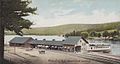 Steamer landing in 1905
 -
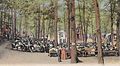 Advent Grove in 1910
 -
 Boarding house in 1907


Geography
According to the United States Census Bureau, the town has a total area of 82.2 square miles (213 km2), of which 63.1 sq mi (163 km2) is land and 19.0 sq mi (49 km2) is water, comprising 23.18% of the town. Alton is drained by the Merrymeeting River. Mount Major, in Mount Major State Forest, has an elevation of 1,780 feet (540 m) above sea level. Popular with hikers, the summit offers unsurpassed views of Lake Winnipesaukee. The highest point in Alton is the north peak of Straightback Mountain, at 1,910 ft (580 m), just west of Mount Major. Both mountains are part of the Belknap Mountains range. Alton lies almost fully within the Merrimack River watershed, though a tiny corner is in the Piscataqua River (coastal) watershed.[5]
The town is served by state routes 11, 28 and 140.
Demographics
As of the censusTemplate:GR of 2000, there were 4,502 people, 1,825 households, and 1,295 families residing in the town. The population density was 71.3 people per square mile (27.5/km²). There were 3,522 housing units at an average density of 55.8/sq mi (21.5/km²). The racial makeup of the town was 98.76% White, 0.07% African American, 0.33% Native American, 0.29% Asian, 0.04% Pacific Islander, 0.07% from other races, and 0.44% from two or more races. Hispanic or Latino of any race were 0.53% of the population.
There were 1,825 households out of which 28.7% had children under the age of 18 living with them, 60.7% were married couples living together, 6.6% had a female householder with no husband present, and 29.0% were non-families. 23.8% of all households were made up of individuals and 10.4% had someone living alone who was 65 years of age or older. The average household size was 2.47 and the average family size was 2.93.
In the town the population was spread out with 23.8% under the age of 18, 5.4% from 18 to 24, 26.7% from 25 to 44, 28.7% from 45 to 64, and 15.4% who were 65 years of age or older. The median age was 41 years. For every 100 females there were 98.9 males. For every 100 females age 18 and over, there were 96.8 males.
The median income for a household in the town was $43,451, and the median income for a family was $46,467. Males had a median income of $37,585 versus $29,375 for females. The per capita income for the town was $25,940. About 5.4% of families and 6.5% of the population were below the poverty line, including 10.4% of those under age 18 and 2.5% of those age 65 or over.
Sites of interest
- Alton Historical Society & Museum
- Harold S. Gilman Museum
- Alton Bay, with an arcade, mini-golf, ice cream shop, multiple areas to eat, a marina, and other attractions
Notable people
- Joel Bean, founder of Beanite Quakerism
- Bobby Carpenter, former ice hockey center with the NHL[citation needed]
- George Franklin Drew, 12th Governor of Florida
- Florence Holway, rape victim, subject of a 2003 HBO documentary
- Al Jolson, early 20th century entertainer (summer resident)[citation needed]
- Steve Leach, former ice hockey right wing with the NHL[citation needed]
- Don Sweeney, former ice hockey defenceman with the NHL[citation needed]
References
- ^ "2009 Population Estimates of New Hampshire Cities and Towns" (PDF). NH Office of Energy and Planning. Retrieved 2010-10-27.
- ^ a b Coolidge, Austin J. (1859). A History and Description of New England. Boston, Massachusetts. p. 409.
{{cite book}}: Unknown parameter|coauthors=ignored (|author=suggested) (help)CS1 maint: location missing publisher (link) - ^ A. Chester Clark, "The Rockwell Clough Company;" The Granite State Monthly, Volume 41, 1909
- ^ The MS Mount Washington, a History -- Lake Winnipesaukee Historical Society
- ^ Foster, Debra H. (1995). Water Use in New Hampshire: An Activities Guide for Teachers. U.S. Department of the Interior and U.S. Geological Survey.
{{cite book}}: Unknown parameter|coauthors=ignored (|author=suggested) (help)
External links
- Town website
- Gilman Library
- Mount Major Snowmobile Club
- New Hampshire Economic and Labor Market Information Bureau Profile
Municipalities and communities of Belknap County, New Hampshire, United States | ||
|---|---|---|
| City |  | |
| Towns | ||
| CDPs | ||
| Other villages | ||
| Footnotes | ‡This populated place also has portions in an adjacent county or counties | |