
Vanadzor: Difference between revisions
No edit summary |
Sergo-Sergo (talk | contribs) No edit summary |
||
| Line 2: | Line 2: | ||
|official_name = Vanadzor |
|official_name = Vanadzor |
||
|name_local = Վանաձոր |
|name_local = Վանաձոր |
||
|image_skyline = |
|image_skyline = 340 Vanadzor.JPG |
||
|image_caption = |
|image_caption = |
||
|imagesize = 300px |
|imagesize = 300px |
||
Revision as of 12:23, 12 March 2011
Vanadzor | |
|---|---|
 | |
 Seal | |
| Country | |
| Marz | Lori |
| Government | |
| • Mayor | Samvel Darbinyan |
| Area | |
| • Total | 25 km2 (10 sq mi) |
| Elevation | 1,424.6 m (4,673.9 ft) |
| Population (2009) | |
| • Total | 104,800 |
| • Density | 4,192/km2 (10,860/sq mi) |
| Time zone | UTC+4 (GMT +4) |
| • Summer (DST) | UTC+5 (GMT+5) |
| Area code | 322 |
| Website | www.vanadzor.ru |
| Sources: Population [1] | |
40°48′46″N 44°29′18″E / 40.81278°N 44.48833°E Vanadzor (Armenian: Վանաձոր) is the third-largest city in Armenia with a population of 107,394 (2001 census) and the capital of the Lori Province. It was previously known as Kirovakan (Armenian: Կիրովական, after Sergey Kirov) during the Soviet era and as Karakilisa during the Tsarist period. The city is considered to be one of the most picturesque in the entire country, having beautiful summer homes or dachas.
History

Much of the city's history is unknown. The history of the area possibly dates back to the Bronze Age, with interesting tombs and other material found and housed in the local museum. But with no doubt, the area of nowadays Vanadzor was part of Gugark, the thirteenth province of the Kingdom of Armenia (Armenia Mayor) until the end of the Artaxiad Dynasty's rule over Armenia, in the 1st century AD.
The city received its name of Karakilisa possibly as early as the 13th century, from a black stone church on a nearby hill. In 1801, it became a part of the Russian Empire along with the Georgian state, a fact that made the city one of the strategically important points for the Russian defensive forces on the border with Persia. In 1826, Karakilisa was totally destroyed by Hasan Khan during the Russo-Persian war. In 1849, it became part of the Yerevan Governorate within the Russian Empire. The city enjoyed considerable uplift through the opening of the railroad to Tbilisi in 1899. The vicinity of the city was the site of the Battle of Karakilisa when in May 1918, General Tovmas Nazarbekian's outnumbered troops, led by Garegin Njdeh successfully defended it from the invading Turkish Army, pushing them back just a few days after the crucial battle of Sardarapat, thus allowing the Democratic Republic of Armenia to come into existence.[2] On the North side of the Spitak-Vanadzor highway, about 2 km West of the city, there is a little shrine in the ruins of a church, site of a planned monument to that battle.
According to Khachatur Abovian, the population of Karakilisa was not more than 600 dwellers in the 1920s, mainly migrants from Yerevan. After becoming part of Yerevan Governorate, the town was flooded with many hundreds of Armenian families, migrated from Kars, Ardahan and Western Armenian cities of Karin and Daroynk (Doğubeyazıt).
Geography

Vanadzor, the capital of Lori, is located 128 km north of Yerevan and 64 km east of Gyumri.
At a height of 1425 meters above sea level, Vanadzor is located next to the valley of Pambak river on the point where the rivers of Pambak, Tantsut and Vanadzor join each other. The third largest city in Armenia, is surrounded with the mountains of Bazum and Pambak that have an altitude of over 2500 meters. The southern and eastern regions are densely forested while to the north and west, they are more dry and often only covered by bushes and plants.
Vanadzor, like Gyumri and Spitak (25 km west), suffered a considerable amount of damage from the 1988 Spitak earthquake during which 564 people died. But unlike the other cities, the majority of buildings, large avenues and the central park were unscathed from the earthquake.
The climate of Vanadzor is characterized with cool summers and relatively mild winters. The average temperature in winter is -4.2 C, while in summer it reaches up to 20 C. Vanadzor's climate is classified as humid continental (Köppen climate classification Dfb).
| Climate data for Vanadzor | |||||||||||||
|---|---|---|---|---|---|---|---|---|---|---|---|---|---|
| Month | Jan | Feb | Mar | Apr | May | Jun | Jul | Aug | Sep | Oct | Nov | Dec | Year |
| Mean daily maximum °C (°F) | 1.5 (34.7) |
2.8 (37.0) |
7.0 (44.6) |
13.5 (56.3) |
18.4 (65.1) |
21.0 (69.8) |
23.3 (73.9) |
23.8 (74.8) |
20.5 (68.9) |
16.5 (61.7) |
9.4 (48.9) |
4.3 (39.7) |
13.5 (56.3) |
| Mean daily minimum °C (°F) | −18.0 (−0.4) |
−17.0 (1.4) |
−13.0 (8.6) |
−5.0 (23.0) |
0.0 (32.0) |
7.0 (44.6) |
4.0 (39.2) |
4.0 (39.2) |
2.0 (35.6) |
−3.0 (26.6) |
−10.0 (14.0) |
−16.0 (3.2) |
−5.4 (22.2) |
| Average precipitation mm (inches) | 18 (0.7) |
25 (1.0) |
36 (1.4) |
63 (2.5) |
96 (3.8) |
95 (3.7) |
58 (2.3) |
43 (1.7) |
32 (1.3) |
47 (1.9) |
33 (1.3) |
19 (0.7) |
565 (22.3) |
| Average precipitation days | 7 | 9 | 11 | 13 | 19 | 17 | 12 | 9 | 10 | 10 | 8 | 7 | 132 |
| Source: World Meteorological Organisation (UN) [3] | |||||||||||||
Industry

Vanadzor is dominated by large chemical plants which include: "Prometey-Khimprom", "Vanadzor Chemical Plant", "Vanadzor Khimprom" and "Vanadzor Chemical Fiber Plant". Another big enterprise is the "Vanadzor Thermal Power Plant.
The chemical industries have a deep root in the city's history. The first chemial plant was founded in 1929 and started to introduce its products in 1932.
In 1999, Russian chemical giants started to enter the Armenian chemical industrial market through investing in Vanadzor plants. After 2001, the chemical and the thermal plants of the city regained their highest capacities of production after a decade of interruption due to the economical collapse in Armenia in the 1990s.
Education and Religion

- Vanadzor has several educational institutions that serve not only the city of Vanadzor, but all the citizens of Lori and Tavush regions. It has two major higher educational centers: the Vanadzor State Pedagogical Institute named after Hovhannes Tumanyan and Mkhitar Gosh Armenian-Russian International University. Branches of Yerevan State University are also operating in the city. 6 technical intermediate colleges, 32 public education schools and 20 nurseries are currently operating (2009). Vanadzor is the home of the Armenian Constitutional Right-Protective Centre (ACRPC) NGO, the leading human rights educational NGO in Armenia. The first ACRPC Human Rights Library Network (HRLN) library was established in Vanadzor in 1996. Being one of the prominent cultural centres of Armenia, the city has a municipal art gallery, a Dramatic Theatre (named after Hovhannes Abelyan) and several cultural institutions.
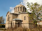
- The vast majority of the population belongs to the Armenian Apostolic Church. Vanadzor is the seat of the Diocese of Gougark of the Armenian Apostolic Church, which includes Lori and Tavush provinces. The church of the Holy Mother of God or Karakilisa (meaning Black church) is one of the oldest preserved churches in the city. The groundbreaking service for the new cathedral of the diocese of Gugark took place in May 2002. Later in 2003, His Holiness Karekin II, Supreme Patriarch and Catholicos of All Armenians, conducted the blessing service for the foundation of the cathedral. The construction of the cathedral was completed in 2005 and named after Saint Gregory of Narek, in the honour of the thousandth anniversary of his Book of Lamentations. The city is home to a small Russian Orthodox community served by the church of the Nativity of Virgin Mary.[4]
- Vanadzor churches
-
 Church of the Holy Mother of God "Karakilisa"
 -
 The Russian Orthodox church of the Nativity of Virgin Mary
 -
 Saint Gregory of Narek Cathedral
 -
 The Prelacy of the Diocese of Gougark
 -
 Holy Children chapel


Notable people

- Stepan Zoryan, an Armenian writer
- Suren Aghababyan, a literary critic
- Artavazd Peleshyan, a documentary film-maker
- Shavarsh Karapetyan, a Soviet Armenian finswimmer
- Vic Darchinyan, World unified boxing champion and the IBF, WBO, WBC champion
- Gor Mkhitarian, an Armenian rock-musician
- Tigran Sargsyan, Prime Minister of Armenia
Sister cities
 Bagneux,_Hauts-de-Seine, France (since 1968)
 Pasadena, California, United States
 Batumi, Georgia
 Podolsk, Russia
Gallery

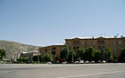
- Vanadzor
-
 Vanadzor city hall
 -
 The railway station
 -
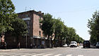 Downtown Vanadzor
 -
 The centre of the city
 -
 Autumn in Vanadzor
 -
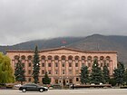 Lori province's administration
 -
 Contemporary Armenian architecture
 -
 Multi-storied apartments
 -
 Apartments with backyards
 -
 Aerial view


References
- ^ Armstats:Population
- ^ Hovhanessian, Richard G. (1997) The Armenian People from Ancient to Modern Times. New York. St. Martin's Press, 299
- ^ "World Weather Information Service – Vanadzor". United Nations. Retrieved 29 December 2010.
- ^ www.gov.am:Religious organizations in Armenia (in Armenian)
- Vanadzor at GEOnet Names Server
- Report of the results of the 2001 Armenian Census, Statistical Committee of Armenia
- World Gazeteer: Armenia – World-Gazetteer.com
