
Rarotonga: Difference between revisions
resized image |
No edit summary |
||
| Line 3: | Line 3: | ||
| native name = |
| native name = |
||
| image name = Rarotonga Island.jpg |
| image name = Rarotonga Island.jpg |
||
| image size = |
| image size = 750px |
||
| image caption = NASA satellite image of Rarotonga. |
| image caption = NASA satellite image of Rarotonga. |
||
| image alt = |
| image alt = |
||
| Line 21: | Line 21: | ||
| largest city = Rarotonga |
| largest city = Rarotonga |
||
| demonym = Rarotongan |
| demonym = Rarotongan |
||
| population = 14. |
| population = 14.133 |
||
| density_km2 = |
| density_km2 = |
||
| ethnic groups = |
| ethnic groups = |
||
Revision as of 03:37, 15 November 2011
 | |
| Geography | |
|---|---|
| Location | Central-Southern Pacific Ocean |
| Coordinates | 21°14′S 159°47′W / 21.233°S 159.783°W |
| Archipelago | Cook Islands |
| Area | 67.39 km2 (26.02 sq mi) |
| Administration | |
| Demographics | |
| Demonym | Rarotongan |
| Population | 14.133 |
Rarotonga is the most populous island of the Cook Islands, with a population of 14,153 (census 2006), out of the country's total population of 19,569.
The Cook Islands' Parliament buildings and international airport are on Rarotonga. Because it is the most populous island, Cook Islanders may often be referred to as Rarotongan, but they may come from one of the other 14 islands in the group, such as Aitutaki or Mangaia. Rarotonga is a very popular tourist destination with many resorts, hotels and motels. The chief town, Avarua, on the north coast, is the capital of the Cook Islands.
Geography
The island of Rarotonga stands over 14,750 feet (4,500 meters) above the ocean floor. It is 32 km (20 miles) in circumference and has an area of 67.19 km² (26 square miles). At a depth of 4,000 m (13,000 ft) the volcano is nearly 31 miles (50 km) in diameter. Te Manga, at 658 m (2,140 ft) above sea level, is the highest peak on the island.
The island is surrounded by a lagoon, which often extends more than a hundred metres to the reef, then slopes steeply to deep water. The reef fronts the shore to the north of the island, making the lagoon there unsuitable for swimming and water sports, but to the south east, particularly around Muri, the lagoon is at its widest and deepest. This part of the island is the most popular with tourists for swimming, snorkelling and boating. Agricultural terraces, flats, and swamps surround the central mountain area.
Along the southeast coast off Muri Beach are four small coral islets within a few hundred metres of the shore and within the fringing coral reef. From north to south, the islets are:[1]
- Motutapu, 11.0 hectares (0.042 sq mi)
- Oneroa, 10.6 hectares (0.041 sq mi)
- Koromiri, 3.0 hectares (0.012 sq mi)
- Taakoka, 1.7 hectares (0.0066 sq mi)
The interior of the island is dominated by eroded volcanic peaks cloaked in dense vegetation. Paved and unpaved roads allow access to valleys but the interior of the island remains largely unpopulated due to forbidding terrain and lack of infrastructure.
A large tract of land has been set aside in the south east as the Takitumu Conservation Area to protect native birds and plants, especially the endangered kakerori, the Rarotonga Flycatcher.
Science
On May 30, 1965, five sounding rockets were launched from Rarotonga for studying a solar eclipse.[2]
Subdivisions

Rarotonga is divided into three main districts. Te Au O Tonga on the northern side of the island (Avarua is the capital), Takitumu on the eastern and southern side and Puaikura on the western side.
Area attractions
Palm-studded white sandy beaches fringe most of the island, and there is a popular cross-island walk that connects Avatiu valley with the south side of the island. This walk passes Te Rua Manga, the prominent needle-shaped rock visible from the air and some coastal areas. Hikes can also be taken to Raemaru, or flat-top mountain. Other stops should include Wigmore Falls (Papua Falls) and the ancient marae, Arai te Tonga.
Popular island activities include snorkeling, scuba diving, bike riding, horse back riding, hiking, deep-sea fishing, boat tours, scenic flights, restaurants, dancing, island shows, squash, tennis, zipping around on mopeds, and sleeping on the beach. There are many churches open for service on Sunday, and the beautiful a capella singing makes them a must. The pace of life is so relaxed that at night people congregate at the sea wall that skirts the end of the runway and watch the jets land.
Transport
There are three harbours, Avatiu, Avarua and Avana, of which only Avatiu harbour is of any commercial significance and serves a small fleet of inter-island and fishing vessels and cargo ships regularly call from New Zealand. Large cruise ships have to anchor off shore.
Rarotonga is encircled by a main road, Ara Tapu, that traces the coast. Three-quarters of Rarotonga are encircled by the ancient inner road, Ara Metua. Approximately 29 km long, this road was constructed in 11th century and for most or all of its whole length was paved with large stone slabs.[3] Along this road are several important marae, including Arai Te Tonga, the most sacred shrine in Rarotonga. Due to the mountainous interior, there is no road crossing the island. Rarotonga has only two bus routes: Clockwise & Anti-Clockwise.[4] Although they are bus stops, the buses pick up and set down anywhere en route.
Rarotonga International Airport is the international airport of the Cook Islands with Air Rarotonga operating inter-island flights: daily flights to Aitutaki, regular flights to Atiu, Mangaia, Mauke and Mitiaro, and occasional flights to the remote Northern Atolls of Manihiki, Tongareva (Penrhyn) and Pukapuka.
In the media
- The travel writer Robert Dean Frisbie died on the island, after having lived there only briefly.
- The 1995 album Finn by The Finn Brothers ends with the song "Kiss the Road of Rarotonga", which was inspired by a motorcycle accident that Tim Finn had during a visit there.
- The U.S. television series Survivor: Cook Islands was filmed on Aitutaki, one of the islands in the southern group. One of the tribes was called Rarotonga (or Raro for short).
- A number of feature-length films are linked to Rarotonga: Merry Christmas, Mr. Lawrence, depicting a Japanese POW camp for British prisoners in the island of Java in the year 1942, was filmed here, The Other Side of Heaven, which is set in Niuatoputapu, Tonga, but was filmed in part on Rarotonga, and Johnny Lingo which was set here.
In the 2008 film Nim's Island, Rarotonga is portrayed as a waypoint for fictional adventure writer Alexandra Rover (Jodie Foster) on her journey from San Francisco to a South Pacific island. Yolanda Vargas Dulche named her novella and heroine after the island, an enigmatic woman with superhuman powers.
Gallery
-
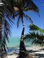
 View of a Rarotongan beach.
 -
 Typical scene along the Ara Tapu (main road) on Rarotonga.
 -
 Rarotonga's highest peak, Te Manga, from the south coast.
 -
 A Rarotonga beach, Avaavaroa.
 -
 White sandy beach at Titikaveka.
 -
 The Ara Tapu (main road) near Tikioki Beach.
 -
 The capital township, the main street of Avarua.
 -
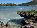
 An islet in the lagoon at Muri Beach.


See also
- Auparu
- Kingdom of Rarotonga
- List of birds of the Cook Islands
- Treaty of Rarotonga
- Roman Catholic Diocese of Rarotonga
- Nukutere College
References
This article needs additional citations for verification. (June 2007) |
External links
21°14′S 159°47′W / 21.233°S 159.783°W
| Northern chain | ||
|---|---|---|
| Southern chain - Nga-pu-Toru | ||
| Southern chain - other | ||