
Spurn: Difference between revisions
m Reverted edits by 87.83.123.50 (talk) to last version by ClueBot NG |
Tag: possible vandalism |
||
| Line 39: | Line 39: | ||
As well as a road, the peninsula also used to have a railway, parts of which can still be seen. Unusual '[[sail bogey|sail bogies]]' were used as well as more conventional light railway equipment.<ref>{{cite web | title = Sails on Rails | url = http://www.copsewood.org/ng_rly/sailbogie/sailbogie.htm | publisher = Mike Munro | accessdate = 8 July 2009}}</ref> |
As well as a road, the peninsula also used to have a railway, parts of which can still be seen. Unusual '[[sail bogey|sail bogies]]' were used as well as more conventional light railway equipment.<ref>{{cite web | title = Sails on Rails | url = http://www.copsewood.org/ng_rly/sailbogie/sailbogie.htm | publisher = Mike Munro | accessdate = 8 July 2009}}</ref> |
||
==Geography== |
|||
The peninsula is made up from sand and shingle eroded from the [[Holderness]] coastline washed down the coastline from [[Flamborough Head]]. Material is washed down the coast by [[longshore drift]] and accumulates to form the long, narrow embankment in the sheltered waters inside the mouth of the Humber estuary. It is maintained by plants, especially [[Marram grass]] (''Ammophila arenaria''). Waves carry material along the peninsula to the tip, continually extending it; as this action stretches the peninsula it also narrows it to the extent that the sea can cut across it in severe weather. When the sea cuts across it permanently, everything beyond the breach is swept away, only to eventually reform as a new spit pointing further south. This cycle of destruction and reconstruction occurs approximately every 250 years. More recently, Dr. John Pethick of Hull University put forward a different theory to explain the formation of Spurn Head. He suggests that the spit head has been a permanent feature since the end of the last [[ice age]], having developed on an underwater glacial [[moraine]]. As the ice sheets melted, sea level gradually rose and [[longshore drift]] caused a spit to form between this and other islands along the [[moraine]]. Under normal circumstances, the sea washes over the neck of the spit taking sand from the seaward side and redepositing it on the landward side. Over time, the whole spit, length intact, slips back - with the spit-head remaining on its glacial foundation. This process has now been affected by the protection of the spit put in place during the [[Victorian era]]. This protection halted the wash-over process and resulted in the spit being even more exposed due to the rest of the coast moving back 100 metres since the 'protection' was constructed. The now crumbling defences will not be replaced and the spit will continue to move westwards at a rate of 2 metres per year, keeping pace with the coastal erosion further north. |
|||
eddy. |
|||
The second of the ''Six Studies in English Folk Song for Cello'' composed in 1926 by [[Ralph Vaughan Williams]], the ''Andante sostenuto'' in E flat "Spurn Point" celebrates this peninsula. |
|||
It was featured on the television programme ''[[Seven Natural Wonders]]'' as one of the wonders of Yorkshire. |
|||
==Ecology== |
==Ecology== |
||
Revision as of 11:32, 9 December 2011
- "Spurn" can have other meanings, see the Wiktionary entry.
| Spurn Head | |
|---|---|
 Spurn in May 2005, showing the lighthouse and sand-dunes. | |
| OS grid reference | TA399108 |
| Civil parish | |
| Unitary authority | |
| Ceremonial county | |
| Region | |
| Country | England |
| Sovereign state | United Kingdom |
| Post town | HULL |
| Postcode district | HU12 |
| Dialling code | 01964 |
| Police | Humberside |
| Fire | Humberside |
| Ambulance | Yorkshire |
| UK Parliament | |
Spurn Point (or Spurn Head as it is also known) is a narrow sand spit on the tip of the coast of the East Riding of Yorkshire, England that reaches into the North Sea and forms the north bank of the mouth of the Humber estuary. It is over 3 miles (4.8 km) long, almost half the width of the estuary at that point, and as little as 50 yards (46 m) wide in places. The southernmost tip is known as Spurn Head or Spurn Point and is the home to an RNLI lifeboat station and disused lighthouse. It forms part of the civil parish of Easington.
Spurn Head covers 280 acres (113 ha) above high water and 450 acres (181 ha) of foreshore. It has been owned since 1960 by the Yorkshire Wildlife Trust and is a designated National Nature Reserve, Heritage Coast and is part of the Humber Flats, Marshes and Coast Special Protection Area.
History

In the Middle Ages, Spurn Head was home to the port of Ravenspurn (a.k.a. Ravenspur or Ravensburgh), where Henry Bolingbroke landed in 1399 on his return to dethrone Richard II. It was also where Sir Martin De La See led the local resistance against Edward IV's landing on 14 March 1471, as he was returning from his six months' exile in the Netherlands.[1] An earlier village, closer to the point of Spurn Head, was Ravenser Odd. Along with many other villages on the Holderness coast, Ravenspurn and Ravenser Odd were lost to the encroachments of the sea, as Spurn Head, due to erosion and deposition of its sand, migrated westward.[2]
The lifeboat station at Spurn Head was built in 1810. Owing to the remote location, houses for the lifeboat crew and their families were added a few years later. The station is now one of only a very few in the UK which has full-time paid staff (the others all being on the River Thames in London).


In World War I two coastal artillery 9.2-inch (230 mm) batteries were added at either end of Spurn Head, with 4-inch (100 mm) and 4.7-inch (120 mm) quick firing guns in between. The emplacements can be clearly seen, and the northern ones are particularly interesting as coastal erosion has partly toppled them onto the beach, revealing the size of the concrete foundations very well. The Information Centre has a leaflet describing the defences.
As well as a road, the peninsula also used to have a railway, parts of which can still be seen. Unusual 'sail bogies' were used as well as more conventional light railway equipment.[3]
eddy.
Ecology
The landward-side mud flats are an important feeding ground for wading birds, and the area has a bird observatory, for monitoring migrating birds and providing accommodation to visiting birdwatchers. Their migration is assisted by east winds in autumn, resulting in drift migration of Scandinavian migrants, sometimes leading to a spectacular "fall" of thousands of birds. Many uncommon species have been sighted there, including a Cliff Swallow from North America, a Lanceolated Warbler from Siberia and a Black-browed Albatross from the Southern Ocean. More commonly, birds such as Wheatears, Whinchats, Common Redstarts and flycatchers alight at Spurn on their way between breeding and wintering grounds elsewhere. When the wind is in the right direction migrants are funnelled down Spurn Point and are counted at the Narrows Watchpoint, more than 15,000 birds can fly past on a good morning in autumn with 3,000 quite normal.
-
 Spurn's Lighthouse
 -
 The pier and launching platform for the RNLI at Spurn
 -
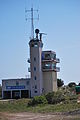 Humber Vessel traffic service
 -
 Spurn Point from the mainland


See also
References
- ^ Bruce, J. (1838). "Historie of the Arrivall of Edward IV". Camden Soc. 1: 4.
{{cite journal}}: Cite journal requires|journal=(help) - ^ "History of Ravenser Odd". Archived from the original on 8 May 2009. Retrieved 15 August 2011.
- ^ "Sails on Rails". Mike Munro. Retrieved 8 July 2009.