
Talk:Control of cities during the Syrian civil war: Difference between revisions
m Archiving 1 discussion(s) to Talk:Cities and towns during the Syrian Civil War/Archive 46) (bot |
|||
| Line 476: | Line 476: | ||
[[User:Hanibal911|Hanibal911]] |
[[User:Hanibal911|Hanibal911]] |
||
Here, the [https://twitter.com/Syria_Rebel_Obs/status/592091900892585984 only pro-opposition source] who said that Zijarah village is still under government control says that rebels actually captured it. Now we have SOHR and pro-opposition sources confirming this village under rebel control. Or do you have something else ? [[User:DuckZz|DuckZz]] ([[User talk:DuckZz|talk]]) 22:52, 25 April 2015 (UTC) |
Here, the [https://twitter.com/Syria_Rebel_Obs/status/592091900892585984 only pro-opposition source] who said that Zijarah village is still under government control says that rebels actually captured it. Now we have SOHR and pro-opposition sources confirming this village under rebel control. Or do you have something else ? [[User:DuckZz|DuckZz]] ([[User talk:DuckZz|talk]]) 22:52, 25 April 2015 (UTC) |
||
Pro SAA sources are saying counter attack has begun sugar factory retaken and fighting at western entrance of City but we need pro opp sources to confirm as we need pro saa sources or neutral to show rebel gains .[[Special:Contributions/86.178.102.168|86.178.102.168]] ([[User talk:86.178.102.168|talk]]) 09:30, 26 April 2015 (UTC) |
|||
Revision as of 09:31, 26 April 2015
| This is the talk page for discussing improvements to the Control of cities during the Syrian civil war article. This is not a forum for general discussion of the article's subject. |
Article policies
|
| Find sources: Google (books · news · scholar · free images · WP refs) · FENS · JSTOR · TWL |
| This page is not a forum for general discussion about Control of cities during the Syrian civil war. Any such comments may be removed or refactored. Please limit discussion to improvement of this article. You may wish to ask factual questions about Control of cities during the Syrian civil war at the Reference desk. |
| This article is of interest to the following WikiProjects: | |||||||||||||||||||||||||||||||||||||||||||||
| |||||||||||||||||||||||||||||||||||||||||||||


.svg)
| To help centralise discussions and keep related topics together, Template talk:Syrian Civil War detailed map redirects here. |
Template:Syrian Civil War sanctions
|
Index 1, 2, 3, 4, 5, 6, 7, 8, 9, 10 |
|
This page has archives. Sections older than 7 days may be automatically archived by Lowercase sigmabot III when more than 3 sections are present. |
IS cuts off key rebel supply route from Jordan to the Damascus countryside
http://syriadirect.org/news/is-cuts-off-key-rebel-supply-route-from-jordan-to-the-damascus-countryside/ I'll let the usual editors look it over to cross reference. Tgoll774 (talk) 20:30, 22 April 2015 (UTC)
Kurdish presence in aleppo
source https://twitter.com/sergermed/status/561985092890144768
https://twitter.com/sergermed/status/560952310776750080
https://twitter.com/sergermed/status/560576534407565312
same account have also mentioned about kurds+fsa rebels in Qazel, Ghara/Yani yaban, Dalhah & Baghirin these villages aren't even marked in this map. — Preceding unsigned comment added by Creepz55 (talk • contribs) 00:49, 2 February 2015
YPG in KOBANE
According to this confirmed source YPG controlls zorava tel aotk korabi and susan are they even marked on the map?
https://twitter.com/ColdKurd/status/561294811094065153 — Preceding unsigned comment added by Creepz55 (talk • contribs) 00:54, 2 February 2015
Joum Ali in kobane.
Joum ali in kobane
https://twitter.com/jackshahine/status/561974858951950336?lang=sv
It's completelly liberated why does the map show ISIS presence? — Preceding unsigned comment added by Creepz55 (talk • contribs) 00:58, 2 February 2015
Latakia
Have the rebel forces advanced in Latakia ? many more villages added and some taken from the SAA ? I have not read of any resent advance ,can someone kindly explain the situation .86.178.97.43 (talk) 18:38, 14 April 2015 (UTC)
SAA is in or near Rabia ... If u change towns, only with Sources please. To much anti-governments editors
WTF is that for nonsense? He/She who changed all those towns to green in Latakia better change it back to red or post some decent sources here.SyAAF (talk) 21:14, 14 April 2015 (UTC)
The area has been changed several times due to different reports. Pro-opposition maps are showing always the same, and editors are changing this region according to them when a pro-gov or neutral source poops ops with a statement which might confirm that. And SOHR and some other sources were reporting that rebels atacked gov positions with GRAD rockets here and there near Latakia city, which might be logical because they are this close, and the range is limited. DuckZz (talk) 08:34, 15 April 2015 (UTC)
No Reliable Source is backing those changes actually? Are you saying that?Mr.User200 (talk) 13:17, 15 April 2015 (UTC)
The editor who made these changes needs to explain why they were changed or they should be reverted as its not one village but a big area .86.178.97.43 (talk) 13:44, 15 April 2015 (UTC)
I have no idea, because i did not change it. But the user posted a pro-government source and a pro-opposition map which both match up, so i guess it's ok as we often use pro-opposition sources combined with government maps to make edits in favor for the government. DuckZz (talk) 10:25, 16 April 2015 (UTC)
Why aren't these changes changed back to the original? Sources are lacking, which means the they need to be changed back. MesmerMe (talk) 20:21, 19 April 2015 (UTC)
Idlib
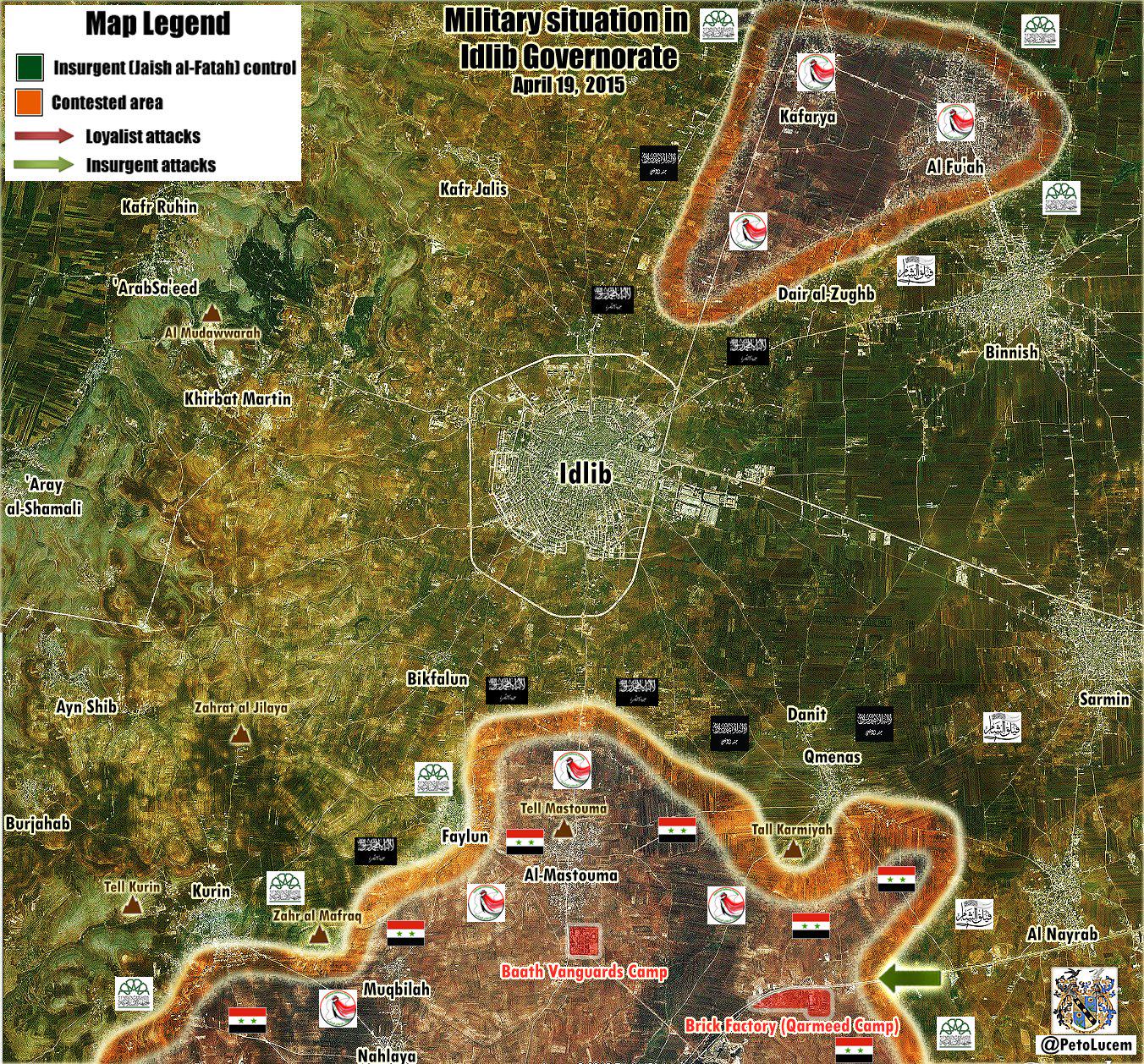
There are many mentions that SAA controlled Najd Kafr and Nahlaya. E.g. http://www.almasdarnews.com/article/syrian-army-makes-fresh-gains-in-idlib-kafr-najd-under-fire-control/ from yesterday evening reports Najd Kafr almost taken. Teh same source states that Qameenas is contested. On the map Najd Kafr is already red, while Nahlaya is contested and Qameenas green. Any neutral source not on twitter reporting this changes?Paolowalter (talk) 12:03, 15 April 2015 (UTC)
- SOHR also confirmed that Syrian troops recatured village of Kafr Najd.SOHR Hanibal911 (talk) 13:32, 15 April 2015 (UTC)
- 1) They are both considered controlled by the gov at the moment anyway. 2) They may have already retreated https://twitter.com/arabthomness/status/588327180830171136 At the very least Kafr Najd should be changed to contested
- SOHR confirmed that the village of Kafr Najd under control of Syrian troops so we cant mark this village as contested on based data from biased pro opposition source. Hanibal911 (talk) 13:52, 15 April 2015 (UTC)
- Pro opposition source said that the Syrian troops gained control over the villages of Kafer Najed and Nahelya in Idlib southern countryside after severe clashes with Islamic battalions.Document.Sy Hanibal911 (talk) 14:06, 15 April 2015 (UTC)
- 1) They are both considered controlled by the gov at the moment anyway. 2) They may have already retreated https://twitter.com/arabthomness/status/588327180830171136 At the very least Kafr Najd should be changed to contested
Acc. pro opposition source: Syrian Army imposes firearms-control over al-Muqblah town in Idlib countryside, after restoring Kafer Najed and Nahlaia today morning. Documents.sy 83.30.58.17 (talk) 18:33, 15 April 2015 (UTC)
- This same source said: As clashes continue with fighters of al-Fateh Army around Feeloun and Qoureen villages in the southern countryside. Faylun - besieged on the south and east? 83.30.58.17 (talk) 18:38, 15 April 2015 (UTC)
- Acc pro gov source ivansidorenko1 and pro rebel TheQalamon about Kurin - is also under control of SAA / fighting in city 83.30.58.17 (talk) 19:35, 15 April 2015 (UTC)
- Pro opposition source also reported that Syrian troops also captured the town of al-Muqblah and that clashes continue with fighters of al-Fateh Army around Feeloun and Qoureen in the southern countryside.Documents.sy Hanibal911 (talk) 20:44, 15 April 2015 (UTC)
- Another one pro opposition source reported that hevy clashes in the village of Kurin and Syrian troops are trying to take over Kurin.Syrian Rebellion Observatory Hanibal911 (talk) 09:09, 16 April 2015 (UTC)
- Another source confirmed that Syrian troops captured three villages of Kafr Najd, Nahlaya and Muqbileh.World Bulletin Hanibal911 (talk) 19:23, 17 April 2015 (UTC)
- Another one pro opposition source reported that hevy clashes in the village of Kurin and Syrian troops are trying to take over Kurin.Syrian Rebellion Observatory Hanibal911 (talk) 09:09, 16 April 2015 (UTC)
- Pro opposition source also reported that Syrian troops also captured the town of al-Muqblah and that clashes continue with fighters of al-Fateh Army around Feeloun and Qoureen in the southern countryside.Documents.sy Hanibal911 (talk) 20:44, 15 April 2015 (UTC)
- Acc pro gov source ivansidorenko1 and pro rebel TheQalamon about Kurin - is also under control of SAA / fighting in city 83.30.58.17 (talk) 19:35, 15 April 2015 (UTC)
- Pro opposition source reported that rebels have withdrawn from the town Kurin because of lack of support from main HQ.Latif MfitaL Hanibal911 (talk) 07:10, 21 April 2015 (UTC)
Khanasser
http://www.almasdarnews.com/article/main-government-supply-line-to-aleppo-cleared-syrian-army-captures-al-rashadiyah/ states that Al-Rashadiyah close to the Khanasser highway is taken by SAA. Where is this village?Paolowalter (talk) 12:10, 15 April 2015 (UTC)
- Paolowalter Here village of Al-Rashadiyah here But need confirmation this data from neutral source becasue Al Masdar it is pro government source and we cant use him for displayed success of Syrian troops. Hanibal911 (talk) 12:30, 15 April 2015 (UTC)
- SOHR reported about clashes in Rashadiyah in Khanasser area near the southern countryside of Aleppo.SOHR Hanibal911 (talk) 13:35, 15 April 2015 (UTC)
https://en.wikipedia.org/w/index.php?title=Talk:Cities_and_towns_during_the_Syrian_Civil_War&action=edit§ion=12 Can someone confirm this and check on FSA claims to have also cut SAA supply routes to Aleppo. A lot of twitter posts about Rebels and IS advances south of Aleppo and cutting the road overnight. Tgoll774 (talk) 13:53, 19 April 2015 (UTC)
- Tgoll774 There conversely army captured some area near the road and are repelled several attacks of ISIS on this road. Hanibal911 (talk) 14:57, 19 April 2015 (UTC)
So basically a propaganda war, like with Baiji and others. But from the video its clear some level of combat is going on in the area from FSA and IS. FSA feeds claim IS hold Khanasser, SAA denies, FSA ah screw it. I say lock all edits for a week till we get better info, because it appears we hit a new mobile phase where settlements change hands every day. Tgoll774 (talk) 15:45, 19 April 2015 (UTC)
Tal Barak updates
According to this Map, which is from a pro-kurd source, Kakah said is with ISIS, also update the hasakah map with SAA advance. Ricardomoha (talk) 19:12, 17 April 2015 (UTC)
- Why am I getting this feeling that this and many others are just WP:CIRC? EllsworthSK (talk) 10:28, 18 April 2015 (UTC)
- Give me a proof not feelings. Ricardomoha (talk) 18:26, 18 April 2015 (UTC)
- Are we using maps? I thought we were trying to abandon using them unless they provided sources to avoid WP:CIRC? Banak (talk) 20:44, 18 April 2015 (UTC)
- That doesn't make sense, because his original map had Kaka said under SAA control on 4/4/2015 and now it's under ISIS control on 18/5/2015, we can take his word because he's a pro-kurdish source. Simple as that. If your point is that this map was maybe taken from old Wiki maps his original map denies that. Ricardomoha (talk) 13:09, 19 April 2015 (UTC)
http://www.agathocledesyracuse.com/wp-content/uploads/2015/03/Khabour-valley-21-April-2015-by-@deSyracuse.png and http://umap.openstreetmap.fr/fr/map/desyracuse-syria-civil-war-21-april-2015_37133#12/36.4826/40.7586 Latest Agacothles de Syracuse Maps. Looks like Tal Barak is under IS administration or contested, but it says control when I click. Tgoll774 (talk) 19:09, 21 April 2015 (UTC)
http://umap.openstreetmap.fr/en/map/twittercetin609-tap-the-map-for-information_36481#15/36.6413/41.0750 Pro-Kurd map for comparing with other map sources. Tgoll774 (talk) 14:45, 22 April 2015 (UTC)
Use of Pro-gov sources to change rebel towns to Nusra
I have noticed that pro-government source PetoLucem https://twitter.com/petolucem often uses Al-Nusra flags in rebel-held territories to imply his viewers that Al-Nusra is in control of those towns.
https://pbs.twimg.com/media/CC-RSZTVAAEzuEN.jpg:large
https://pbs.twimg.com/media/CCyrc8nWEAATHdm.jpg:large
I think that we should not use this pro-govermnet source to edit rebel towns to Al-Nusra control, as this is an attempt by PetoLucem to brand most of the rebels as extreme jihadists who are part of al-Qaeda, to make people turn to his side. Secondly, him putting black Nusra flags does not necessarily mean that towns under these flags are under direct al-Nusra control; it simply is showing that al-Nusra forces are present on those front lines fighting. I think that if we keep doing this, eventually all of the green towns will be turned to grey simply because petolucem has black flags on his map. I also do not think he qualifies as a reliable source to prove al-Nusra control. Let me also say that I am not pro-rebel, pro-government, or pro-Nusra. I just think these towns should not be turned to grey because PetoLucem says they should. 2601:0:B200:F7D9:1547:CFD2:5C0E:E250 (talk) 19:20, 19 April 2015 (UTC)
- The map you show is of Idlib. Al-Nusra has a dominant presence there, that is why all the flags are black. This is confirmed by multiple sources. If you look here at this Daraa map: https://twitter.com/PetoLucem/status/571759910653992960 you will see that there are in fact FSA flags plus nusra flags on it. I do not think he deliberately attempts to brand the rebels as Al-Qaeda. Problem is, rebels cooperate frequently with them, making it hard to determine who controls what. Still, I agree that we should use neutral sources for such changes. XJ-0461 v2 (talk) 19:41, 19 April 2015 (UTC)
Petolucem said on twitter more than once that he belives Al Nusra controls 80% of rebel towns, which is crazy but he knows what kind of news his followers want to see. He is not an extreme pro-regime reporter like Leith Fadel for example but he understands that 80% of his readers are pro-government oriented, and they want that "Syrian army vs Al Qaeda" scenario, that's the reason they hate other rebel groups, mostly because the world needs no reason to hate ISIS or Al Nusra, but every other group seems to have some kind of a "OK" reputation. DuckZz (talk) 20:18, 19 April 2015 (UTC)
- DuckZz If you believe that I was wrong when using these maps when would I noted the villages which is under the control of Al Nusra I revert those my actions or I can mark these villages as under jointly control rebels/Al Nusra. Hanibal911 (talk) 20:26, 19 April 2015 (UTC)
Hanibal911 I can't revert it, because of, do it yourself. DuckZz (talk) 20:43, 19 April 2015 (UTC)
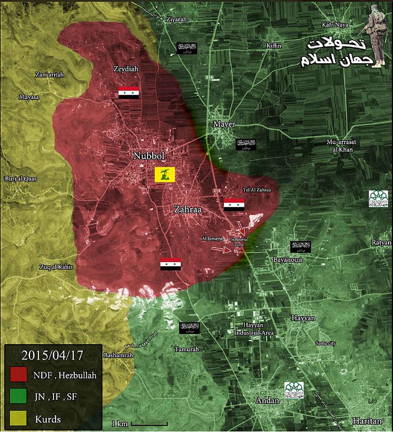
- DuckZz I again mark villages of Mayer and Bayanoon as under control by rebels and Rityan as under jointly control as it was earlier but I mark as under jointly control the village of Tannurah which is I add according to data from pro government source and Ziyarah which is I edit from under Kurdish control to under jointly control FSA/JAN. So that the villages of Ziyarah and Tannurah will be marked as under jointly control before we not find to more data. Hanibal911 (talk) 20:57, 19 April 2015 (UTC)
You can't use government sources for those changes, revert it, and use kurdish sources if you think something may need to be changed, but everything else should be reverted. DuckZz (talk) 21:03, 19 April 2015 (UTC)
- DuckZz You can point me that I need fix and and I will do it because just so it will be easier for me. Hanibal911 (talk) 08:08, 20 April 2015 (UTC)
YPG east of Sarrin
YPG has taken control over several villages and hills east of Sarrin, among them are known several villages whose names begin with Qirat, and a village which in Kurdish is called Serekaniye. http://www.4.hathalyoum.net/580799-%D8%A7%D9%84%D9%82%D9%88%D8%A7%D8%AA-%D8%A7%D9%84%D9%83%D8%B1%D8%AF%D9%8A%D8%A9-%D8%AA%D8%B3%D9%8A%D8%B7%D8%B1-%D8%B9%D9%84%D9%89-4-%D9%82%D8%B1%D9%89-%D9%88%D8%AA%D9%84%D8%A7%D9%84-%D8%A7%D8%B3%D8%AA%D8%B1%D8%A7%D8%AA%D9%8A%D8%AC%D9%8A%D8%A9-%D8%A8%D9%85%D8%AD%D9%8A%D8%B7.html
http://www.syrianewsapp.com/1/Article/2114/83262104#.VTQTAiGqqko
http://www.alahednews.com.lb/fastnews/267296/%D8%A7%D9%84%D9%88%D8%AD%D8%AF%D8%A7%D8%AA-%D8%A7%D9%84%D9%83%D8%B1%D8%AF%D9%8A%D8%A9-%D8%AA%D8%B3%D9%8A%D8%B7%D8%B1-%D8%B9%D9%84%D9%89-%D8%B9%D8%AF%D8%A9-%D9%82%D8%B1%D9%89-%D9%81%D9%8A-%D8%A7%D9%84%D8%AC%D8%A8%D9%87%D8%A9-%D8%A7%D9%84%D8%AC%D9%86%D9%88%D8%A8%D9%8A%D8%A9-%D8%A7%D9%84%D8%B4%D8%B1%D9%82%D9%8A%D8%A9-%D9%84%D9%83%D9%88%D8%A8%D8%A7%D9%86%D9%8A#.VTQTECGqqko Roboskiye (talk) 20:54, 19 April 2015 (UTC)
This source says Qirat and Mitras villages were captured. But we should wait for SOHR or other twitter sources DuckZz (talk) 21:28, 19 April 2015 (UTC)
Nabe' El Murr - Latakia
Here is my point of view on how Nabe' El Murr is regime held:
- 1- Nabe'El Murr overlooks Kessab thus allowing fire control over the village and the crossing.
- 2- Rebel sources mentioning regime advances FROM Nabe' EL Murr towards Jabal Zahya where the SAA has captured Tall Snan and Tallat Wasat. [1] [2] [3] This advance was not possible if the regime did not control Nabe' EL Murr.
- 3- Rebel sources saying they shelled regime positions in Nabe' EL Murr [4] [5] [6]
- 4- Regime forces do control Mount AL Nisr, and this directly and easily overlooks the whole area and easily controls Nabe' El Murr. If the rebels were inside the village they are sitting ducks.
- The only thing contradicting me is the Al-Masdar article that said Nabe' EL Murr is rebel-held. Your thoughts? ChrissCh94 (talk) 21:31, 19 April 2015 (UTC)
I belive we should change it to contested. Pro-opposition sources said that they are trying to advance towards Kessab, and this means Nabe El Murr is not rebel held but contested as Al Masdar has noted. DuckZz (talk) 21:39, 19 April 2015 (UTC)
- ChrissCh94DuckZz Pro opposition sources reported that they not control Nabe' El Murr and we need mark him as under control by Syrian troops. Source Al Masdar make many mistakes he said that rebels start offensive near Kessab but pro opposition source Cédric Labrousse said that this was just a small campaign near Kessab and Tower 45 created in fact with one goal : divide the regime forces advancing at dlib southern coutryside.Syrian Rebellion ObservatorySyrian Rebellion Observatory So that it was just a small attack for that would distract the Syrian army from their offensive on the city of Idlib. SOHR also just said that about clashes between regime Syrian troops and their allied against rebels and the Islamic militant from another party, near the Observatory 45.SOHR Also another the pro opposition source reported that only Al Masdar reported that the rebel attacked Syrian troops in the area the border crossing. And that rebel channels have not released news about the attack.EA WorldView So maybe the Chief editor of Al Masdar was wrong when he said that Nabi al Murr under control by rebels. Also another pro government source showed that Nabi al Murr under control by Syrian troops.here So we have data from the pro opposition sources from SOHR and from pro government source that Nabi al Murr under control by Syrian troops but rebels located to east from him. So we need marked him as under control by Syrian troops. But we marked him as under rebels control only on base the data from pro opposition source which is dated on the end of December 2014 and on the one report from Al Masdar. But many other sources said that he under control by troops and this wrong because data from pro opposition source too outdated and pro government source maybe was wrong because his data not support other pro government sources. And pro opposition source deSyracuse also showed that this town under control by troops.here but rebel positions located to east from him. Hanibal911 (talk) 07:27, 20 April 2015 (UTC)
Some more info from http://www.almasdarnews.com/article/jabhat-al-nusra-attack-on-kassab-repelled/. Nabe' El Murr is back under SAA control, previously was contested. I'd say re dwith a green hal ring on the right.Paolowalter (talk) 07:03, 20 April 2015 (UTC)
Turning Nabe' El Murr contested is unreasonable. It used to be red (see above) it was turned green on the basis of an Al Masdar report and Al Masdar shortly after remarked that the town is back to SAA control. Beside Al Masadr being reliable in general, Al Masdar is not announcing a SAA advance but a short lived rebel advance, followed by restoration of the previous status quo. Therefore Nabe' El Murr back to red as it used to be.Paolowalter (talk) 11:48, 21 April 2015 (UTC)
Rebel presence in the mountains near Bureij and Hisyah
I think we should add a rural presence to signal the presence of rebels in the mountain range. A very interesting article by the neutral Al Safir newspaper (frequently quoted by AL Monitor due to its neutrality) that was shared by the pro-gov facebook page shows what rebels control in AL Qalamoun [7]: 3000 rebels controlling 1000km2 of territory including: Tal'at Moussa (aka Moussa MT) - Barouh Mount etc. (dozens of mounts and areas) but most importantly, they control the mountains near Bureij and Jawsiah and Qara. I already said that we cannot add all those mountain peaks but we could resume that by adding rebel rural presence in the space between Qara and Jawsiah crossing. Oh and I suggest removing those 2 mounts near Flita, there are dozens of those and they clutter the map. ChrissCh94 (talk) 21:52, 19 April 2015 (UTC)
- ChrissCh94
 Done I add mark which showed rebels presence to west from Qara and Bureij between the town of Qara and Jawsiah. Hanibal911 (talk) 06:53, 20 April 2015 (UTC)
Mseikeh & NE Daraa
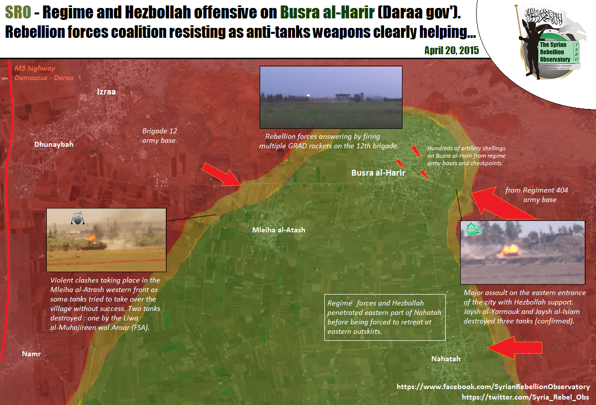
It seems that the SAA 5th has launched an attack on NE Daraa and has captured 5 villages. Mseikeh is the only one that is in the map and should be changed to Government held. Sources are pro-opp and pro-gov.
According to document sy. SAA captured Miskya al-Sharqia and al-Gharbiya, al-Khwabe, Ishnan, al-Dallafa https://www.facebook.com/documents.sy/posts/929032690492821 Miskiyah location: http://wikimapia.org/#lang=tr&lat=32.911874&lon=36.341915&z=14&m=bHwinsp (talk) 11:26, 20 April 2015 (UTC)
- Biased a pro opposition source also reported that the Regime troops launched new offensive on the town of Busra al-Harir.Archicivilians Hanibal911 (talk) 11:32, 20 April 2015 (UTC)
- I didn't mention the other villages captured since I had a very hard time finding any of them. Anybody had any luck? MesmerMe (talk) 11:41, 20 April 2015 (UTC)
other villages probably here: http://wikimapia.org/#lang=tr&lat=32.871586&lon=36.331959&z=13&m=b&gz=0;363000297;328518313;581073;281162;350189;305669;0;89404;263500;0;538158;78590;568199;271070Hwinsp (talk) 11:45, 20 April 2015 (UTC)
- Would it be smart to include one of the village to indicate that Busra al-Harir is surrounded (http://wikimapia.org/#lang=en&lat=32.877857&lon=36.338654&z=12&m=b&show=/31775463/Village)? To include all of them isn't necessary since they're likely very small. MesmerMe (talk) 11:55, 20 April 2015 (UTC)
- Pro government source reported that Syrian troops captured villages East Maseekat, West Maseekat, Rassum Al-Khawaabi, Ishnaan, and Al-Dalasat in northeast Dara.Al Masdar Hanibal911 (talk) 12:18, 20 April 2015 (UTC)
Pro Rebel source https://twitter.com/Syria_Rebel_Obs/status/590141059986026496 says that the SAA is attacking Nahtah from the East. There should be a red circle on the right side of the town. MesmerMe (talk) 13:45, 20 April 2015 (UTC)
- SOHR also confirmed that the Syrian troops cut all supply line of rebels between the town of Busra al Harir and other rebel positions in the Lajat after captured villages near Busra al Harir.SOHR Hanibal911 (talk) 14:07, 20 April 2015 (UTC)
- Maybe we need add red semicircles near villages which is under control by rebels in Lajat becasue the pro opposition source and SOHR clear said that Syrian troops cut all rebel supply lines in Lajat and that now rebels in this area under siege becasue they in blockaded after all their supply lines with another territory under control by rebels.SOHRSyrian Rebellion ObservatorySyrian Rebellion Observatory For now we have situation is the same as well as to the north of the city of Homs where the some towns and villages are under the control of the rebels but cut off from supply lines. Hanibal911 (talk) 14:29, 20 April 2015 (UTC)
- I agree. These towns are currently fully surrounded much in the same nature as Northern Homs. MesmerMe (talk) 14:37, 20 April 2015 (UTC)
- These two to almost identical situations. Also so we have noted previously some villages which is was under the control of the army in the Idlib province near the town Maarat Numan and military bases (Wadi Daif and Hamidiyah) before they were captured. Those villages were also cut off from the supply lines. Hanibal911 (talk) 15:16, 20 April 2015 (UTC)
- Also my actions confirmed the pro opposition source.Syrian Rebellion Observatory He also reported that the Regime take over the supply lines and villages between Lajat area and Busra al Harir. Hanibal911 (talk) 17:40, 20 April 2015 (UTC)
- These two to almost identical situations. Also so we have noted previously some villages which is was under the control of the army in the Idlib province near the town Maarat Numan and military bases (Wadi Daif and Hamidiyah) before they were captured. Those villages were also cut off from the supply lines. Hanibal911 (talk) 15:16, 20 April 2015 (UTC)
- I agree. These towns are currently fully surrounded much in the same nature as Northern Homs. MesmerMe (talk) 14:37, 20 April 2015 (UTC)
- Maybe we need add red semicircles near villages which is under control by rebels in Lajat becasue the pro opposition source and SOHR clear said that Syrian troops cut all rebel supply lines in Lajat and that now rebels in this area under siege becasue they in blockaded after all their supply lines with another territory under control by rebels.SOHRSyrian Rebellion ObservatorySyrian Rebellion Observatory For now we have situation is the same as well as to the north of the city of Homs where the some towns and villages are under the control of the rebels but cut off from supply lines. Hanibal911 (talk) 14:29, 20 April 2015 (UTC)
WHy have all changes been reverted? The only reports that are available say that they've retreated from Busra al-Harir, not from the villages they've already caputured.MesmerMe (talk) 16:14, 21 April 2015 (UTC)
SOHR reported only retreat from Busra al-Harir not from any other village. The video used to support the revert is in arab and I can't understand it. In any case it is a pro-opp outlet and cannot be used to support rebel advance. Please go revert.Paolowalter (talk) 16:38, 21 April 2015 (UTC)
There were changes based on Agathocle map but then they were self reverted. Why?Paolowalter (talk) 16:38, 21 April 2015 (UTC)
- Agothocle's also shows an extremely different situation in Latakia, but we cannot use him as a source. come on, this is old news!! MesmerMe (talk) 18:15, 21 April 2015 (UTC)
Pro opposition source said, that rebels recapture all village, but it is only pro opposition source, acording pro regime source SAA enter Busra al-Harir. I am looking source to changes all the villages on the green. 83.30.58.250 (talk) 18:24, 21 April 2015 (UTC)
The villages need reverting unless reliable sources can be shown .86.178.97.69 (talk) 19:05, 21 April 2015 (UTC)
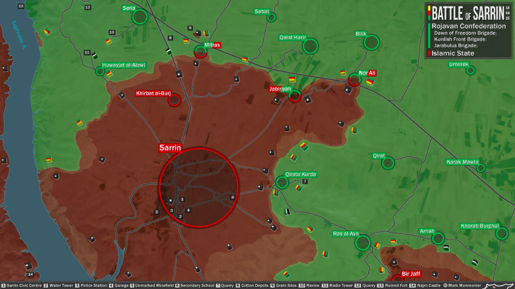
YPG/rebels offensive against ISIS in Sarrin
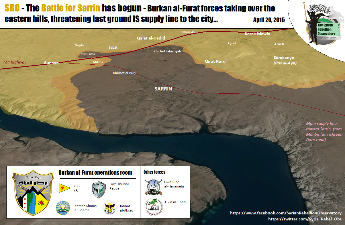
Pro opposition and pro Kurdish source reported that Kurdish troops(YPG) jointly with moderate rebels started major offensive against ISIS in area near the town of Sarrin that would capture the town.Syrian Rebellion ObservatoryMark Monmonier and that YPG/rebels captured some villages and hill near this town and now trying cut the last supply line from the main of ISIS positions to north toward the town of Sarrin. Maybe someone have more data about this offensive. Hanibal911 (talk) 17:23, 20 April 2015 (UTC)
According to SOHR YPG captured the three villages that surround Sarrin (no names specified), with the only supply route left being through the Euphrates river towards IS held areas west of it, indicating YPG control over areas south of the town:
http://www.syriahr.com/2015/04/مصرع-10-عناصر-على-الأقل-من-تنظيم-الدولة/
186.112.206.36 (talk) 03:11, 22 April 2015 (UTC)
https://7496bff410df41fc380ad565a50f607d4b1e8372.googledrive.com/host/0BzN49CdHSAwmcGU4eEI5dVBGZXM/SarrinCity-2015-04-22.png Pro-YYPG source to compare with other sources. Tgoll774 (talk) 15:38, 23 April 2015 (UTC)
Balancing the map
I think the template is a bit imbalanced. For example, there are a lot of blank areas and then suddenly a clutter of villages/farms. This makes viewers and readers think that the blank spaces correspond to an empty desert area which is not the case. So what I suggest is the following:
- Reduce the number of villages that clutter far from a frontline such as: the Kurdish and regime held areas south of Qamishli, just keep the ones on the outside so we could know the limits of control but reduce the ones in the center a bit. If we know who controls the outline we don't have to fill the center. Another suggestion is the ISIS-held area in Eastern Homs. Remove some villages/farms from the center of the area without changing the frontline. There is also the Latakia villages near Durin, just keep the ones separating rebel from regime held areas.
- I also suggest adding some towns/villages in south-west Aleppo between the Khanasser Safira road and Abou l Douhour airbase and south of AL Hadir. It is empty while in fact it is mostly rebel-held thus tricking people into thinking that Abu l Duhur can be reached by regime forces.
Your thoughts fellow editors? ChrissCh94 (talk) 18:03, 20 April 2015 (UTC)
- Let's leave it at that. If we start to just removed or add on map the villages or cities we can provoke negative consequences because some new editors and are not quite disciplined editors can harm the map. We must not without reason, add or delete villages and towns. Let's leave it at that. Dont need to provoke actions that ultimately can harm for map. So that as I said on the map can begin series of unjustified changes. So I'm against it. Hanibal911 (talk) 19:28, 20 April 2015 (UTC)
- I agree with ChrissCh94 — Preceding unsigned comment added by 137.73.84.13 (talk) 11:02, 22 April 2015 (UTC)
- Why can't we make some of these dots smaller on the map? Then we could still know their locations if and when the front lines change, and they wouldn't be as noticeable. I think that this is a good compromise between these 2 views. 2601:0:B200:F7D9:C819:4EE0:A8BF:ABB3 (talk) 22:52, 20 April 2015 (UTC)
- I know this might sound crazy, but can we turn the map to become more interactive (I mean zoom-able by interactive), if not for all parts of the map, at least for some parts like Idlib and Khabour. I'm not an expert in wikipedia programming, but I simplify the logic to this: if someone puts cursor over south of Idib it zooms in or shows a more clear map. The more clear map might be just normal zooming or another map that we add over. Ricardomoha (talk) 16:04, 21 April 2015 (UTC)
- I don't think that's possible. It would be very difficult to implement, and would make the map even more confusing. 2601:0:B200:F7D9:D4D5:B002:E9CF:1AB1 (talk) 01:05, 22 April 2015 (UTC)
ISIS Capture Aadah Mount
ISIS Capture Aadah Mount and Several Important Points in Palmyra Desert.
http://syrian-mirror.net/en/cat/syria-mirror/isis-capture-aadah-mount-and-several-important-points-in-palmyra-desert/ (Jack6780 (talk) 23:59, 20 April 2015 (UTC))
- Firstly It is just data from the antigovernment source and secondly he just said that ISIS captured mount of Aadah near Alyaniyah area in Palmyra desert, after fierce clashes against opposition forces. Hanibal911 (talk) 07:29, 21 April 2015 (UTC)
Regime offensive in Busr Al Harir
Why did we not show the SAA gains? ChrissCh94 (talk) 19:08, 21 April 2015 (UTC)
I restored the situation before the removal of the gain of SAA in this area.Paolowalter (talk) 19:27, 21 April 2015 (UTC)
The pro-opposition source http://syriadirect.org/news/syria-direct-news-update-4-21-15/ states today that the offensive was repelled at Busr Al Harir but reports the yesterday advance of SAA without any mention that those gain have been reverted.Paolowalter (talk) 19:45, 21 April 2015 (UTC)
- This is common, I call it the rebel "shrinking pains". Even time there is a successful regime offensive, they will have claimed to have revered completely within 24 hours[As well as have killed "thousands" of regime soldiers]. So far, the most reliable source we have is a sky-news [pro-opp] video present by SOHR [pro-opp]. The best thing to do is wait for confirmation from a reliable source or wait until one side implicitly or explicitly concedes defeat. XJ-0461 v2 (talk) 20:38, 21 April 2015 (UTC)
Who changed them to green? >86.178.97.69 (talk) 20:47, 21 April 2015 (UTC)
- We saw it in Aleppo (Handarat Pashqoi), in the Daraa-Quneitra-RifDimashq area (Deir el Adas etc.) and in Latakia (Durin) to name a few. SOHR and rebel sources claimed to repulse the offensive and denied the advances but we all saw later on that the regime did gain ground. Not saying regime sources are always spot on and reliable. On the contrary, this is war and propaganda is present in all sides. But at least SANA mentions retreats/defeats by saying that troops "REPOSITIONED" themselves (cf. Tabqa, Nawa, Idlib). ChrissCh94 (talk) 21:30, 21 April 2015 (UTC)
- the pro-regime crowd is not backing down from their claims of current control. Al-Manar video from 2h ago [supposedly] :https://twitter.com/IvanSidorenko1/status/590625283163738112 XJ-0461 v2 (talk) 23:51, 21 April 2015 (UTC)
Latakia
Agathocle map http://umap.openstreetmap.fr/fr/map/desyracuse-syria-civil-war-21-april-2015_37133#11/35.7543/36.0530 confirms our old front line. That was changed only on the basis of Al mansar report http://www.almasdarnews.com/article/syrian-army-on-the-move-in-northern-latakia-turkish-border-crossing-within-distance/ (never confirmed by other sources) that later was made obsolete by http://www.almasdarnews.com/article/jabhat-al-nusra-attack-on-kassab-repelled. Therefore all the area west of Kabir must go red.
Agathocle himself said that he was offline for 2 months and made the map according to frontline news. And he is somehow neutral, while Leith Fadel is extreme pro-government orinanted. Also we have other pro-oposition sources confirming Al Masdar reports. DuckZz (talk) 20:08, 21 April 2015 (UTC) DuckZz (talk) 20:07, 21 April 2015 (UTC)
We already marked Nab Al Mur back to red. Step by step, no need to rush and change everything. DuckZz (talk) 20:57, 21 April 2015 (UTC)
- @deSyracuse not neutral source most of changes on this map here he made on based the data from the pro opposition sources(including pro opp. maps) and also some time he coopirated with another pro opposition source (archicivilins) and we have discussed this many times and has been proven that it's pro opposition source. So that this guy not a neutral source. Also earlier we agreed not use this map to displayed succes of all antigoveenment groups(including ISIS) so dont need break the previously agreed rules. Hanibal911 (talk) 21:15, 21 April 2015 (UTC)
- Partialy I agree with DuckZz no need to rush and again, mark all the villages as under control of army but also I still think we were wrong when we on based on the outdated pro opposition map and comments from pro-government activist pointed out so many villages under rebel control because other pro government sources showed a completely different situation. Hanibal911 (talk) 21:25, 21 April 2015 (UTC)
- Let's just keep it as it is for the moment as a sort of compromise. If we encounter some new sources then we'll bring up the subject again. ChrissCh94 (talk) 21:32, 21 April 2015 (UTC)
- Partialy I agree with DuckZz no need to rush and again, mark all the villages as under control of army but also I still think we were wrong when we on based on the outdated pro opposition map and comments from pro-government activist pointed out so many villages under rebel control because other pro government sources showed a completely different situation. Hanibal911 (talk) 21:25, 21 April 2015 (UTC)
Agothocle has admitted that he used the wikipedia map as his source,so there is alot of doubt on it,archicivilians map best describes the situation,which leith confirmed.Alhanuty (talk) 23:01, 21 April 2015 (UTC)
Strongly pro-opp map here https://twitter.com/Conflict_Report/status/590608725985067008 clearly show that the locations between Qastal Maaf and Rabia are under SAA control. These positions includes Ateera and Al-Sooda that must go back to red.Paolowalter (talk) 08:34, 22 April 2015 (UTC)
Semi-protected edit request on 22 April 2015
This edit request to Module:Syrian Civil War detailed map has been answered. Set the |answered= or |ans= parameter to no to reactivate your request. |
change
{ lat = "33.104", long = "36.739", mark = "Location dot red.svg", marksize = "6", label = "al-Asfar", link = "#no", label_size = "0", position = "top" },
to
{ lat = "33.104", long = "36.739", mark = "Location dot black.svg", marksize = "6", label = "al-Asfar", link = "#al-Asfar", label_size = "0", position = "top" },
and
{ lat = "33.007", long = "36.739", mark = "80x80-red-black-anim.gif", marksize = "6", label = "al-Qasr", link = "#no", label_size = "0", position = "right" },
to
{ lat = "33.007", long = "36.739", mark = "Location dot black", marksize = "6", label = "al-Qasr", link = "#al-Qasr", label_size = "0", position = "right" },
source:
http://www.understandingwar.org/backgrounder/syria-situation-report-april-14-21-2015
2601:0:B200:F7D9:D4D5:B002:E9CF:1AB1 (talk) 01:01, 22 April 2015 (UTC)
- How many times I must say you that this antigovernment source which we cant use for displayed success rebels and ISIS. This source support all who against Syrian troops and he called Syrian troops as regime forces or Assad troops and we not use against Syrian troops all source which call Syrian troops as regime force. The only exception was made for SOHR becasue his data used many reliable sources. Several days ago pro-ISIS source said that ISIS captured those villages and now this source just duplicated those data need confirmation from neutral sources or SOHR. Hanibal911 (talk) 12:31, 22 April 2015 (UTC)
- I am sorry. I thought since ISW was anti-ISIS and a reliable source, it could be used show an ISIS advance. It seems to me unlikely that they would report this from some pro-ISIS media outlet without verifying it first. 2601:0:B200:F7D9:148:D945:1A4:80B3 (talk) 19:58, 22 April 2015 (UTC)
Supply lines to Lajat reopened
http://syriahr.com/en/2015/04/37-fighters-from-rebel-and-islamic-battalions-killed-during-clashes-in-dara/ — Preceding unsigned comment added by 137.73.84.13 (talk) 01:49, 22 April 2015 (UTC) :SOHR does not say which towns were recaptured, only areas around Busr al-Harir. Also, since this is SOHR, I would wait for a neutral source. Although, I am surprised that the more rebels were killed. That really is something. XJ-0461 v2 (talk) 02:48, 22 April 2015 (UTC)
This SOHR report does not say villages were taken by rebels and its in English which has proven to be unreliable so the villages should be marked red .86.178.97.69 (talk) 07:21, 22 April 2015 (UTC) As long as there is no mention of change of control of towns with names explicitly written or reliable map we must retain the Lajat map with SAA controlled towns. The usual vandal changed it, please could somebody revert this change (I would break the 1RR rule).Paolowalter (talk) 07:43, 22 April 2015 (UTC)
SOHR is reliable,so shut up,it clearly mentioned that all areas taken by regime forces in the offensive have been recaptured by the rebel,which includes all towns,and Paolowalter,if you don't stop your personal attacks,i will be reporting you for your vandalizing behavior,understood.Alhanuty (talk) 12:15, 22 April 2015 (UTC)
You fucking braindead, SOHR is the biggest casualty cheaters of all time. Their sources are "activists" who work for al nusra. LOL "reliable"
- Seriously, SOHR is not reliable. All changes should be reverted, since there is absolutely no evidence. These are vandal changes that are highly favourable to the rebels. 12:41, 22 April 2015 (UTC)MesmerMe (talk)
Agree the editor who made these changes needs to be told how edits work and if they continue blocked .86.178.97.140 (talk) 16:14, 22 April 2015 (UTC)
SOHR has established itself as authentic source throughout the entire Syrian Civil War,it was decided so based on Major News Source,and it the conclusion was reached in 2012,way before alot of the new editors cam here. https://www.facebook.com/syriahro/videos/10153299975868115/.Alhanuty (talk) 17:36, 22 April 2015 (UTC)
- Today is 2015 year and now we have many new, more reliable source than SOHR. Many time we discussed here about SOHR and their mistakes. You need to confirm this, SOHR is pro opposition. I don not see any proof to recapture this villages, only biased markito. Every time if SAA capture some ground, than next day rebels claims that they recapture all area without proof. Show evidence or obviously breaking the rules here established - using pro rebel source to show rebel advance. I do not see any one photo or video from these areas 83.30.54.5 (talk) 18:40, 22 April 2015 (UTC)
Recently sohr English translation made major mistakes it was decided not to use it as a sole source editor Hanibal911 stated this and all others agreed — Preceding unsigned comment added by 86.178.97.140 (talk) 18:53, 22 April 2015 (UTC)
Alhanuty SOHR never said rebels retake villages only regain ground around Busra harir read the report and stop making lies or we report you .86.178.97.140 (talk) 19:29, 22 April 2015 (UTC)
The Arabic SOHR report confirmed that regime forces lost all areas they captured since the start of the offensive,so stop making up things,SOHR is still reliable more reliable than the pro-regime sources you listen to.Alhanuty (talk) 19:34, 22 April 2015 (UTC)
- Enough making up facts. A new consensus as been reached. One, SOHR English is not to be used and SOHR Arabic is to be used with a corroborating source. SOHR is to a reliable source to be used alone, not anymore. XJ-0461 v2 (talk) 20:02, 22 April 2015 (UTC)
- Your only source is this video? For me, it is just as reliable SAA general which say that they capture 5 village. Since yesterday, there is no photo or video of these villages, but if rebel destroy some tank they upload video in 5 minutes. I find this map Islamic World News more reliable than SOHR 83.30.54.5 (talk) 20:13, 22 April 2015 (UTC)
who are you to make up rules here,you people just made accounts like just months ago,and want to dictate,which source is to be used and which doesn't,plus,maybe editors with a pro-regime stance are with you,but alot of neutral editors aren't with these extreme opinions.Alhanuty (talk) 22:13, 22 April 2015 (UTC) plus that is a pro-regime map.Alhanuty (talk) 22:13, 22 April 2015 (UTC)
- Alhanuty was right because SOHR clear said that Syrian troops retreated and rebels regain control of five villages which they lost earlier. Hanibal911 (talk) 22:34, 22 April 2015 (UTC)
- Alhaunty, You do understand that your "seniority" gives no NO extra say in matters right? Also, waiting for a neutral source to back SOHR is not an "extreme option" .[In an 8-5 vote, editors agreed to this, so no minority here]. Hanibal, could you please link the SOHR article where its says that. Last time, you linked a SOHR link that cited pro-opp sky-news. P.S. Al-Monitor confirms villages in SAA hands:http://www.al-monitor.com/pulse/security/2015/04/syria-daraa-rural-takfiri-terrorists-offensive-bisr-al-qasab.html [This article is about as current as the SOHR article claiming rebel recapture.]XJ-0461 v2 (talk) 22:41, 22 April 2015 (UTC)
- I only saw that SOHR said regime forces retreated from the vicinity of Busr AL Harir. And rebel sources always claim they recaptured lost ground immediately. I find this funny because at this rate, they should have captured all of Syria by now and not less than a quarter of it. ChrissCh94 (talk) 10:39, 23 April 2015 (UTC)
- ChrissCh94 Ok if a reliable source Al Monitor confirmed that those villages still control by Syrian troops we must trust this data. Hanibal911 (talk) 10:45, 23 April 2015 (UTC)
Once again SOHR is wrong how many more times must this happen before we all stop using it as a single source for edits .SOHR needs to be confirmed like other sources .86.178.102.166 (talk) 14:01, 23 April 2015 (UTC)
Map problem
Some of you may have noticed. The map has problems with updating recent edits. Just wanted to write this so that evevryone knows it's the same for every user. DuckZz (talk) 08:16, 22 April 2015 (UTC)
- Oh good, my connection is not going bad. Is there anything that can be done to fix it though? XJ-0461 v2 (talk) 20:07, 22 April 2015 (UTC)
- DuckZz, XJ-0461 v2 has this been fixed? What was the problem? I can't see any problems at the moment, but want to be sure the map is accurate when I update the .png one from this one. Also I can't see what would have caused it, perhaps it was a module that this one depends on. Banak (talk) 14:52, 23 April 2015 (UTC)
ISIS counterattack in Sarrin countryside?
May be someone has a data from neutral sources about situation around city of Sarrin. Becasue a pro Kurdish sources reported that they advanced and captured several villages. But pro ISIS source reported that ISIS launched counterattack and recaptured villages of Qerat,Ra's Al 'Ayn, Erna and Kark.hereGeneral Shami Hanibal911 (talk) 16:40, 23 April 2015 (UTC)
Was just about to ask the same thing, because Pro-Kurd sources are also contradicting themselves on the grain silos, and where YPG forces are stationed. Some say the silos are taken, others say IS repulsed the assault despite airstrikes, and others are saying they are fighting in Sarrin itself, others say they are being pushed back by IS counter-offensive. I think what is going on is that because both sides are thin on forces there, small units on both sides are punching each other at the same time as IS moves up fresh company sized forces to replace fought out units and atritt YPG and hit their smaller detachments with maimum force while Airstrikes hit largely vacated positions. Similar to what the NVA did Tgoll774 (talk) 16:53, 23 April 2015 (UTC)
https://pbs.twimg.com/media/CDSSbkVUkAAeAcZ.jpg Chuck Pfarer a pro-YPG source, but yesterday he said YPG took the silos, now he has backtracked. https://twitter.com/freelancejorno/status/591352696990466049/photo/1 Pro-IS saying IS has successfully counter-attacked. I don't see any other sources so I can't say what is going on, but its pretty clear heay fighting is going on and YPG backtracked on saying they captured the silos. https://twitter.com/mrasiell/status/591337540088700929 Pro-IS Source. Don't know at this point, just going to have to see what other sources come up. But it looks like with Tishrin Secured, the YPG have hit the limits of their advance. Tgoll774 (talk) 21:54, 23 April 2015 (UTC)
https://pbs.twimg.com/media/CDTtgO6UgAAWAeF.jpg Pro YPG source, but admits Khirbat al-Burj and Qirat Kurdan, as seen on the map as retaken by IS, Ras al-Ayn looks contested. Tgoll774 (talk) 02:38, 24 April 2015 (UTC)
https://pbs.twimg.com/media/CDdoE0SXIAAFxZw.png:large Pro-Kurd
https://twitter.com/mraseill/status/592025037038837760/photo/1 Pro-IS
https://pbs.twimg.com/media/CDdi9O2UsAAP3h5.jpg Pro-Kurd
Leave it to you guys to cross reference Tgoll774 (talk) 20:36, 25 April 2015 (UTC)
Editing with pro-side sources
I think that LightandDark2000 doesn't have a clue with what sources he is editing example here he is using a pro-side source, here,also he is editing without any sources to here.Lindi29 (talk) 17:17, 23 April 2015 (UTC)
- I agre with Lindi29 such actions break the rules of editing with which we all agreed dont use the pro government sources to show the success of the Syrian army (as well as the Kurds in the province of Hasaka where they co-operate with the army) and do not use all the anti-government sources to show the success of the rebels and ISIS in their fight against Syrian troops because these sources are openly opposed to the Syrian army (also dont use pro opposition sources to show the success of the Kurds in the province of Aleppo, where they collaborate with the rebels). And also we have agreed not to use the pro government sources (because pro government sources openly oppose the rebels) to show success of ISIS or Al Nusra in their fight against moderate rebels. Hanibal911 (talk) 17:55, 23 April 2015 (UTC)
- The maps originated from another site, which I have not yet found. Some of the information has been reported via other sources, but the ones I am using are the only ones I can find that provide regular updates. I believe that it is best to use the resources available, rather than squabble over a few controversial issues. If there are clear conflicting reports, I will always try to stick with the more reputable/neutral source. Best regards, LightandDark2000 (talk) 05:48, 24 April 2015 (UTC)
Sugar Factory
Pro-gov source report on the sugar factory amid fierce clashes,here.Lindi29 (talk) 19:01, 23 April 2015 (UTC)
- Lindi29 Just need put semicircle near this factory and nothing more. As we earlier made near Brick Factory which was attacked Al Nusra before they retreated.Latif HassanSyrian Rebellion Observatory. Hanibal911 (talk) 19:14, 23 April 2015 (UTC)
- Lindi29 But pro government source also indicated that the clashes in surroundings of this factory but not inside this factory.Leith Al-Halabi so for now not need any actions let us wait more data. Hanibal911 (talk) 19:25, 23 April 2015 (UTC)
- Hanibal911 OK,then put a semicircle near the factory.Lindi29 (talk) 20:05, 23 April 2015 (UTC)
- Also pro opposition source confirmed that the city of Jisr al-Shughur still under control by Syrian troops and that rebels and Al Nusra still located on distance of 3-4 km from the city.Conflict ReporterConflict ReporterConflict Reporter and another pro opposition source Cedric Labrousse also confirmed that the Jisr al-Shughur is still under regime control as rebellion forces took some checkpoints north, west and east to city.Syrian Rebellion Observatory and that rebels didn't take any real strategic objective as the offensive aimed to do. Qarmid battle turned to blood bath.Syrian Rebellion Observatory and regime Ghab plain defense line (despite Simaniyah defeat) is more strongest contrary to what was expected.Syrian Rebellion Observatory Hanibal911 (talk) 20:50, 23 April 2015 (UTC)
- Lindi29Rebels just shelling Sugar factory here so for now not need put semicircle but still need monitor the situation. Hanibal911 (talk) 21:00, 23 April 2015 (UTC)
- Hanibal911 shelling and clashes are confirmed by both sides so the semicircle is needed.Lindi29 (talk) 21:23, 23 April 2015 (UTC)
- I'm with a semi-circle but not more. The rebels are waging an important psychological war ever since their semi-successful counterattack in Aleppo in February. They claim victories before (if they) happen. Yesterday all rebel sources claimed the Qarmeed aka Brick factory was captured. Today we saw it shell rebel positions. Same goes for all checkpoints, bases etc. Waiting a few days is no problem considering the fluidity of the frontline. To be fair, rebels are winning the media war that's for sure. Regime media outlets are lacking in war coverage and loyalists are becoming more and more demoralized. ChrissCh94 (talk) 22:06, 23 April 2015 (UTC)
- That depends on what media war you are talking about. The international media war is in favor of the SAA. More people abroad than even oppose the rebels. However, you are correct about the domestic media war. The rebels managed to, very early, get their super weapon into the arena "SOHR". For almost 3 years, it was one of the only sources for events in Syria. Whether you were pro-opp or pro-gov, you read SOHR. This effect has lessened, but is still strong. The SAA also seems to be making the mistake of not even trying to wage a media war. If you look at the Deir-ez-zor front, you will see numerous videos by the SAA of weapons seized, positions taken, and dead ISIS fighters being dragged through the streets. I believe this to be one of the reasons why ISIS's media war in Deir-ez-Zor is a failure. Other than there, however, the SAA has not been active since their old strategy of "deny deny deny" failed. The rebels constantly post videos of their exploits, even if they are faked, giving the illusion of daily progress. That is why the rebels' most fervent supports are still confident in total victory. If the SAA wants to turn the tide, they THEMSELVES [not their loyalists] have to start making ISIS style propaganda videos. Show captured positions, weapons, and dead rebels. Make the SAA appear larger than life, this strategy worked great for ISIS and has been proven effective for Gen. Zahhridine in Deir-Ez-Zor. XJ-0461 v2 (talk) 22:54, 23 April 2015 (UTC)
- I'm with a semi-circle but not more. The rebels are waging an important psychological war ever since their semi-successful counterattack in Aleppo in February. They claim victories before (if they) happen. Yesterday all rebel sources claimed the Qarmeed aka Brick factory was captured. Today we saw it shell rebel positions. Same goes for all checkpoints, bases etc. Waiting a few days is no problem considering the fluidity of the frontline. To be fair, rebels are winning the media war that's for sure. Regime media outlets are lacking in war coverage and loyalists are becoming more and more demoralized. ChrissCh94 (talk) 22:06, 23 April 2015 (UTC)
- Lindi29 But pro government source also indicated that the clashes in surroundings of this factory but not inside this factory.Leith Al-Halabi so for now not need any actions let us wait more data. Hanibal911 (talk) 19:25, 23 April 2015 (UTC)
- ChrissCh94 Here pro opposition source but not such dreamer as a archicivilians clear showed that rebels shelled this factory from distance herehere So for now not need put semicircle. This pro opposition source clear showed that factory in area which still controled of army and rebels position to east from factory from where they shelled him. Hanibal911 (talk) 06:28, 24 April 2015 (UTC)
- I put grey semicircle near Manshara Checkpoint and green semicircle near Bshlamon Checkpoint that would show that the clashes in surroundings of the plant. Hanibal911 (talk) 07:48, 24 April 2015 (UTC)
- SOHR also reported that clashes near the city of Jisr Shughour.SOHR Hanibal911 (talk) 13:08, 24 April 2015 (UTC)
- I put grey semicircle near Manshara Checkpoint and green semicircle near Bshlamon Checkpoint that would show that the clashes in surroundings of the plant. Hanibal911 (talk) 07:48, 24 April 2015 (UTC)
Eastern Ghouta
Guys I don't know why Mayda'a and Zebdin are marked as regime held. SAA forces pushed into them but retreated via loyalist sources showing them under rebel control ever since their summer offensive: [8] [9] [10] [11] I could not find newer sources partly because it has been a calm frontline. ChrissCh94 (talk) 22:22, 23 April 2015 (UTC)
- Mayda'a was from SOHR, but Zebdin is only partly controlled by the SAA, but no one has fixed it since. I do not know how to. XJ-0461 v2 (talk) 00:18, 24 April 2015 (UTC)
- ChrissCh94 They both contested. Hanibal911 (talk) 05:51, 24 April 2015 (UTC)
Contested perhaps, but not regime held, change it to contested then. — Preceding unsigned comment added by 177.157.18.68 (talk) 10:26, 24 April 2015 (UTC)
- I agree either contested or rebel-held but definitely not regime held. ChrissCh94 (talk) 17:42, 24 April 2015 (UTC)
- ChrissCh94 I ask editor which updates maps and he update map and mark these towns as contested. Although now he busy but he updat map later. I necessarily remind him about this! Hanibal911 (talk) 18:01, 24 April 2015 (UTC)
- Hanibal911 Thank you! ChrissCh94 (talk) 19:02, 24 April 2015 (UTC)
- ChrissCh94 I ask editor which updates maps and he update map and mark these towns as contested. Although now he busy but he updat map later. I necessarily remind him about this! Hanibal911 (talk) 18:01, 24 April 2015 (UTC)
- I agree either contested or rebel-held but definitely not regime held. ChrissCh94 (talk) 17:42, 24 April 2015 (UTC)
Semi-protected edit request on 23 April 2015
This edit request to Module:Syrian Civil War detailed map has been answered. Set the |answered= or |ans= parameter to no to reactivate your request. |
please 2601:3:3880:494:7DB4:C0C4:5251:502D (talk) 23:09, 23 April 2015 (UTC)
 Not done as you have not requested a change. Please mention the specific changes in a "change X to Y" format. --I am k6ka Talk to me! See what I have done 02:29, 24 April 2015 (UTC)
Tall hamaka
No reason to put Tall-Hamaka green. We are back to take SOHR as the source of truth. Other sources no more partisan than SOHR states the opposite: https://twitter.com/PetoLucem/status/591614810837618689 and https://twitter.com/IvanSidorenko1/status/591612029724663810. Just let's put it contested and wait.Paolowalter (talk) 15:23, 24 April 2015 (UTC)
according to sohr arabic ,saa recaptured tall hamaka http://www.syriahr.com/2015/04/%D8%A3%D9%83%D8%AB%D8%B1-%D9%85%D9%86-44-%D8%BA%D8%A7%D8%B1%D8%A9-%D8%B9%D9%84%D9%89-%D9%85%D8%AD%D9%8A%D8%B7-%D8%AC%D8%B3%D8%B1-%D8%A7%D9%84%D8%B4%D8%BA%D9%88%D8%B1-%D9%88%D8%A7%D8%B3%D8%AA%D8%B9/176.42.119.155 (talk) 16:08, 24 April 2015 (UTC)
Khalkhalah air base under seige
ISIS appears to have this base under seige following its recent assault there: IS jihadists 'down regime aircraft in south Syria' Nulla Taciti (talk) 15:48, 24 April 2015 (UTC)
- Source just said that ISIS shut down aircraft the Syrian aircorce and that according to data from SOHR the fate of crew members remains unknown. Source also said that ISIS tried to storm the airport on 11 April but loyalist forces maintained control of it.The Daily Mail Also early reliable source also confirmed that when ISIS attacke Syrian troops counterattacked and pushed bask ISIS. Here earlier several reliable sources confirmed that the Syrian troops repelled an attack on a key Syrian airport during a fierce battle in which they lost 20 fighters but killed almost as many militants, activists said. Rami Abdel Rahman, the head of the SOHR said there was an attack on the outskirts of the Khalkhalah military airport in Sweida province but the army has been able to maintain control over the airport and its surrounding areas despite losing 20 fighters. At least 15 militants were killed. Although the Observatory was awaiting confirmation on the identity of the attackers, Abdel Rahman told AFP they were likely to have been jihadis from ISIS.The Daily StarThe Malaysian InsiderNaharnetAgency France PressThe Economic TimesKhaleej Times You need carefully read your source before making statements. Hanibal911 (talk) 16:14, 24 April 2015 (UTC)
- Not exactly sure what you are saying Hanibal911. The fact that ISIS has positioned themselves outside the airbase and is apparently downing aircraft at their leisure would suggest an update to the map might be in order, although I'm happy to wait for additional sources. Nulla Taciti (talk) 16:25, 24 April 2015 (UTC)
- Nulla Taciti Any fighter from ISIS could shot down the Syrian Aircaraft from long diastance so this not confirm that ISIS also located near airport and even more so that he in the siege of ISIS. And many reliable source clear said that later troopp pushed ISIS from area near airport and surrounding area. And that for now ISIS not located near this area. So your data even indirectly not indicates that the airport is surrounded by ISIS. Hanibal911 (talk) 16:45, 24 April 2015 (UTC)
- Not exactly sure what you are saying Hanibal911. The fact that ISIS has positioned themselves outside the airbase and is apparently downing aircraft at their leisure would suggest an update to the map might be in order, although I'm happy to wait for additional sources. Nulla Taciti (talk) 16:25, 24 April 2015 (UTC)
Hudhud SAA held ?
Is the town of Hudhud east of Manjib really SAA held ? and if so how did they get there as all places around are ISIL held .Can someone explain thankyou .86.178.97.133 (talk) 16:39, 24 April 2015 (UTC)
- 86.178.97.133 Here is the editor without any foundation noted this village under the control of the army.here It is unjustified action that violates the ruleы of editing. Hanibal911 (talk) 16:50, 24 April 2015 (UTC)
Rebel Hama/Idlib offensive
Section for questions and request of changes DuckZz (talk) 21:36, 24 April 2015 (UTC)
Jisr ash-Shughur has fallen under Jaysh al-Fatah control.
Or at the very least, is being contested. I have no idea whether it should be listed as Green or Grey, since both Jabhat al-Nusra and Ahrar ash-Sham are operating in/around this area.
https://twitter.com/IvanSidorenko1/status/591860301055700993 (pro-Gov source showcasing JaF in Jusr ash-Shughur
http://i.imgur.com/aV7yzto.png (picture from pro-Rebel source showing list of conquered buildings)
https://twitter.com/AFP/status/591869301663010819 (AFPfr claiming that the city has fallen outright to JaF)
- Al Nusra and several Islamist factions control large parts city of Jisr al-Shughour troop still control hospital SOHR and pro opposition source confirmed that Syrian troops still control hospital and the area on southern outskirts of the city here Hanibal911 (talk) 07:55, 25 April 2015 (UTC)
- And remember that Ivan Sidorenko not pro government source he just publish data from some sources pro opposition and pro government. And SOHR clear said that Al Nusra and several Islamist factions control large parts city of Jisr al-Shughour. And your source Agence France-Presse also said that Al Qaeda and allies overrun city of Jisr al-ShughurAgence France-Presse not only rebels. And pro opposition source confirmed that army still control hospital on outskirts. Hanibal911 (talk) 08:05, 25 April 2015 (UTC)
- Again as I said in the first post. At the very least, this city is contested. — Preceding unsigned comment added by 76.126.188.171 (talk) 08:32, 25 April 2015 (UTC)
- 76.126.188.171 I marked the city under the control of Al Nusra and insurgents, and added the hospital which under control of the army. And reliable sources and SOHR reported that Al-Nusra Front and its allies took control of almost all the city.Al ArabiaAgence France-Presse And this confirmed that at least hospital still controled Army. Nevertheless, I marked city under control by Al Nusra and rebels. Hanibal911 (talk) 08:55, 25 April 2015 (UTC)
- And pro opposition sources also said that Al Nusra and rebels captured largest part of city. But also pro opposition source also confirmed that for now the National Hospital it is the main stronghold of Syrian troops in Jisr al-Shughour.here Hanibal911 (talk) 09:09, 25 April 2015 (UTC)
- SOHR said clashes are still continuing in some pockets of Syrian troops and their allies in the southwest of the city.SOHR Hanibal911 (talk) 10:36, 25 April 2015 (UTC)
- And pro opposition sources also said that Al Nusra and rebels captured largest part of city. But also pro opposition source also confirmed that for now the National Hospital it is the main stronghold of Syrian troops in Jisr al-Shughour.here Hanibal911 (talk) 09:09, 25 April 2015 (UTC)
- And remember that Ivan Sidorenko not pro government source he just publish data from some sources pro opposition and pro government. And SOHR clear said that Al Nusra and several Islamist factions control large parts city of Jisr al-Shughour. And your source Agence France-Presse also said that Al Qaeda and allies overrun city of Jisr al-ShughurAgence France-Presse not only rebels. And pro opposition source confirmed that army still control hospital on outskirts. Hanibal911 (talk) 08:05, 25 April 2015 (UTC)
Hanibal911 The sugar factory and Bishlaymun were captured last night. I have only pro-opposition sources so someone else needs to agree so i can change it. Also they said that rebels captured the hospital too. DuckZz (talk) 11:00, 25 April 2015 (UTC)
And again I have the same problem with this joint control. Al Nusra did participate, like in every offensive, but how much ? I have already posted a source where the Idlib council says that Idlib will not be controled by a Rebel group but by the council itself, and it's said that "JAN moves on", and this Jisr Shugur offensive is just the confirmatiom. Idlib is still under joint control.
- This opposition infographic shows what groups did participate in Idlib/Hama offensive. I can post every group and their videos/pictures, just to confirm their presence. My question is, how come that 22 groups are smaller than Al Nusra, and even Al Nusra was using another logo in their videos/pictures, to show presence of other groups mixed with them. I don't want to post 50 videos from IF and etc groups, that would be ridiculous. DuckZz (talk) 11:19, 25 April 2015 (UTC)
- DuckZz This only data from pro Al Nusra source and we cant use this data for displayed success of rebels. And military sources denied this and reported that all southern area near Jisr al Shughour including Sugar factory and hospital still under full control of troops.here So that we need confirmation from neutral source. Hanibal911 (talk) 11:21, 25 April 2015 (UTC)
- Let's not start again this discussion. Reliable sources have clearly indicated that the city was taken by Al Nusra and several Islamic groups. And we cant use in this issue pro opposition sources. Hanibal911 (talk) 11:25, 25 April 2015 (UTC)
Bishmalun is west of Jisr Shugur. It has been captured last night (according to pro-rebel sources). This video is from this morning showing IF members in this village capturing a checkpoint near it (means they already captured the village itself) DuckZz (talk) 11:39, 25 April 2015 (UTC)
Hanibal911 And yes, i want to hear what other editors think about this. I belive that Jisr Shugur shouldn't go under Joint control. The areas around it are already marked as grey. The town is full of videos from other rebel groups. But i'm not the one to decide. DuckZz (talk) 11:39, 25 April 2015 (UTC)
- DuckZz But Al Nusra claimed that this their victory.Also, if you look closely you will see that in the city visible only black flags of Al Qaeda. hereherehereherehereherehere Hanibal911 (talk) 12:02, 25 April 2015 (UTC)
Hanibal911 As you can see. Those pictures show both JAN and rebel fighters. The same pictures are published by IF and other rebel groups because they show their fighers, and JAN. To prove this, look at the pictures, you can see 2 logos, one shows JAN, the other for Rebel groups. But whatever, we both know that we have different views, i want other editors to give their opinions. Something else, map is published by IF showing the situation, it looks like SAA fled from the entire area to Istabrag. DuckZz (talk) 12:23, 25 April 2015 (UTC)
- DuckZzBut this [here] only claim from Islamic Front but we not confirmation from reliable(neutral) sources that this map showed true situation. Also I was never against what would hear constructive opinions from other editors but if they are not biased and without insults. Hanibal911 (talk) 12:29, 25 April 2015 (UTC)
Hanibal911 Here, the only pro-opposition source who said that Zijarah village is still under government control says that rebels actually captured it. Now we have SOHR and pro-opposition sources confirming this village under rebel control. Or do you have something else ? DuckZz (talk) 22:52, 25 April 2015 (UTC)
Pro SAA sources are saying counter attack has begun sugar factory retaken and fighting at western entrance of City but we need pro opp sources to confirm as we need pro saa sources or neutral to show rebel gains .86.178.102.168 (talk) 09:30, 26 April 2015 (UTC)