Hinterriß: Difference between revisions
Appearance
Content deleted Content added
add wikilink |
Hociminlio (talk | contribs) Added {{expand language}} tag to article (TW) |
||
| Line 1: | Line 1: | ||
{{expand language|topic=|langcode=de|otherarticle=Hinterriß|date=June 2015}} |
|||
{{unreferenced|date=April 2013}} |
{{unreferenced|date=April 2013}} |
||
[[File:Hinteriss WV kirche gasthof zur post ds 05 2007.jpg|thumb|right|Hinterriß]] |
[[File:Hinteriss WV kirche gasthof zur post ds 05 2007.jpg|thumb|right|Hinterriß]] |
||
Revision as of 15:33, 13 June 2015
You can help expand this article with text translated from the corresponding article in German. (June 2015) Click [show] for important translation instructions.
|

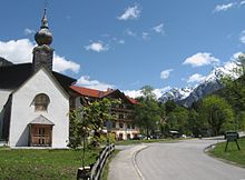
Hinterriß is a Tyrolean village in Schwaz District, Austria, located at the Rißbach river at a height of 928 metres. Legally, Hinterriß is split up between the municipalities of Vomp and Eben am Achensee. According to the latest census, Hinterriß has a total population of 54.
The Karwendel mountain range separates Hinterriß from the rest of Austria. The only road connection leads through German territory, as such Hinterriß is considered a practical exclave. However, unlike Jungholz and the Kleinwalsertal, Hinterriß never had a special status.
A toll-free road connects Hinterriß with Vorderriß, located in Germany. In the other direction, a toll road accessible only in summer connects Hinterriß with the small village of Eng.
