Daymark: Difference between revisions
Appearance
Content deleted Content added
embed {{Authority control}} with wikidata information |
complete rewrite Tags: nowiki added Visual edit |
||
| Line 1: | Line 1: | ||
{{Unreferenced stub|auto=yes|date=December 2009}} |
|||
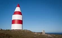
[[File:The Daymark, St Martins.jpg|thumb|right|Daymark on [[St Martin's, Isles of Scilly]] ]] |
[[File:The Daymark, St Martins.jpg|thumb|right|Daymark on [[St Martin's, Isles of Scilly]] ]] |
||
A '''daymark''' or a '''day marker''' is the daytime identifier of an [[Navigational aid|aid to navigation]] (ATON). |
|||
A '''daymark''' or a '''day marker''' is a structure, such as a [[tower]] constructed on land, that serves as an [[navigational aid|aid to navigation]] by sailors. Similar in concept to a [[lighthouse]], a daymark does not have a light and so is usually only visible during daylight hours, although a lighthouse may be built as a daymark. Some disused lighthouses remain useful by serving as daymarks. |
|||
Generally, the daymark conveys to the mariner, during daylight hours, the same significance as does the aid's light or reflector at night. <ref>{{Cite book|title = Light List, Volume II, Atlantic Coast|last = |first = |publisher = US Government Printing Office|year = 2015|isbn = |location = Washington, DC|pages = ix}}</ref> |
|||
The [[Jersey Round Tower|Archirondel]] and [[Le Hocq]] towers on [[Jersey]], built for purposes of coastal defence, now serve as daymarks. |
|||
== Daymark Chart Symbols<ref>{{Cite book|title = US Chart No. 1: Symbols, Abbreviations and Terms |
|||
used on Paper and Electronic Navigational Charts|last = |first = |publisher = Department of Commerce |
|||
National Oceanic and Atmospheric Administration |
|||
Department of Defense |
|||
National Geospatial-Intelligence Agency|year = 2013|isbn = |location = |pages = 86}}</ref> == |
|||
{| class="wikitable" |
|||
!Paper Chart |
|||
!Simplified |
|||
!Simplified Symbol Name |
|||
! |
|||
|- |
|||
|<nowiki>[[File:Square or rectangular daymark - Paper Chart.PNG|thumb|Square or rectangular daymark - Paper Chart]]</nowiki> |
|||
|<nowiki>[[File:Square or rectangular daymark - Simplified chart.PNG|thumb|Square or rectangular daymark - Simplified chart]]</nowiki> |
|||
|Square or rectangular daymark |
|||
| |
|||
|- |
|||
|<nowiki>[[File:Triangular daymark point up - Paper Chart.PNG|thumb|Triangular daymark point up - Paper Chart]]</nowiki> |
|||
|<nowiki>[[File:Triangular daymark point up - Simplified Chart.PNG|thumb|Triangular daymark point up - Simplified Chart]]</nowiki> |
|||
|Triangular daymark, point up |
|||
| |
|||
|- |
|||
|<nowiki>[[File:Triangular daymark, point down - Paper Chart.PNG|thumb|Triangular daymark, point down - Paper Chart]]</nowiki> |
|||
|<nowiki>[[File:Triangular daymark point down - Simplified Chart.PNG|thumb|Triangular daymark point down - Simplified Chart]]</nowiki> |
|||
|Triangular daymark, point down |
|||
| |
|||
|- |
|||
|<nowiki>[[File:Retro reflector - Paper and Simplified Chart.PNG|thumb|Retro reflector - Paper and Simplified Chart]]</nowiki> |
|||
|<nowiki>[[File:Retro reflector - Paper and Simplified Chart.PNG|thumb|Retro reflector - Paper and Simplified Chart]]</nowiki> |
|||
|Retro reflector |
|||
| |
|||
|} |
|||
==See also== |
==See also== |
||
Revision as of 00:52, 1 October 2015

A daymark or a day marker is the daytime identifier of an aid to navigation (ATON).
Generally, the daymark conveys to the mariner, during daylight hours, the same significance as does the aid's light or reflector at night. [1]
Daymark Chart Symbols[2]
| Paper Chart | Simplified | Simplified Symbol Name | |
|---|---|---|---|
| [[File:Square or rectangular daymark - Paper Chart.PNG|thumb|Square or rectangular daymark - Paper Chart]] | [[File:Square or rectangular daymark - Simplified chart.PNG|thumb|Square or rectangular daymark - Simplified chart]] | Square or rectangular daymark | |
| [[File:Triangular daymark point up - Paper Chart.PNG|thumb|Triangular daymark point up - Paper Chart]] | [[File:Triangular daymark point up - Simplified Chart.PNG|thumb|Triangular daymark point up - Simplified Chart]] | Triangular daymark, point up | |
| [[File:Triangular daymark, point down - Paper Chart.PNG|thumb|Triangular daymark, point down - Paper Chart]] | [[File:Triangular daymark point down - Simplified Chart.PNG|thumb|Triangular daymark point down - Simplified Chart]] | Triangular daymark, point down | |
| [[File:Retro reflector - Paper and Simplified Chart.PNG|thumb|Retro reflector - Paper and Simplified Chart]] | [[File:Retro reflector - Paper and Simplified Chart.PNG|thumb|Retro reflector - Paper and Simplified Chart]] | Retro reflector |
See also
Look up daymark in Wiktionary, the free dictionary.
Wikimedia Commons has media related to Daymarks.
- ^ Light List, Volume II, Atlantic Coast. Washington, DC: US Government Printing Office. 2015. pp. ix.
- ^ US Chart No. 1: Symbols, Abbreviations and Terms used on Paper and Electronic Navigational Charts. Department of Commerce
National Oceanic and Atmospheric Administration
Department of Defense
National Geospatial-Intelligence Agency. 2013. p. 86.
{{cite book}}: line feed character in|publisher=at position 23 (help); line feed character in|title=at position 50 (help)

