
Talk:Control of cities during the Syrian civil war: Difference between revisions
| Line 373: | Line 373: | ||
Assad's forces control Tel Ambassador from the nearby village of Jabboul after another against ISIS. https://twitter.com/24Aleppo/status/657958483917197313 [[Special:Contributions/91.124.122.78|91.124.122.78]] ([[User talk:91.124.122.78|talk]]) 16:56, 24 October 2015 (UTC) |
Assad's forces control Tel Ambassador from the nearby village of Jabboul after another against ISIS. https://twitter.com/24Aleppo/status/657958483917197313 [[Special:Contributions/91.124.122.78|91.124.122.78]] ([[User talk:91.124.122.78|talk]]) 16:56, 24 October 2015 (UTC) |
||
: Pro-SAA tweets are not a reliable source. [[Special:Contributions/84.138.74.98|84.138.74.98]] ([[User talk:84.138.74.98|talk]]) 16:59, 24 October 2015 (UTC) |
|||
== Sources for Idlib changes == |
== Sources for Idlib changes == |
||
Revision as of 16:59, 24 October 2015
| This article was nominated for deletion on 23 July 2015. The result of the discussion was keep. |
| This is the talk page for discussing improvements to the Control of cities during the Syrian civil war article. This is not a forum for general discussion of the article's subject. |
Article policies
|
| Find sources: Google (books · news · scholar · free images · WP refs) · FENS · JSTOR · TWL |
| This page is not a forum for general discussion about Control of cities during the Syrian civil war. Any such comments may be removed or refactored. Please limit discussion to improvement of this article. You may wish to ask factual questions about Control of cities during the Syrian civil war at the Reference desk. |
| This article has not yet been rated on Wikipedia's content assessment scale. It is of interest to the following WikiProjects: | |||||||||||||||||||||||||||||||||||||||||||||||||||||||
Please add the quality rating to the {{WikiProject banner shell}} template instead of this project banner. See WP:PIQA for details.
Please add the quality rating to the {{WikiProject banner shell}} template instead of this project banner. See WP:PIQA for details.
Please add the quality rating to the {{WikiProject banner shell}} template instead of this project banner. See WP:PIQA for details.
| |||||||||||||||||||||||||||||||||||||||||||||||||||||||


.svg)

| To help centralise discussions and keep related topics together, Template talk:Syrian Civil War detailed map redirects here. |
Template:Syrian Civil War sanctions
 | Rules for Editing the Map
1- A reliable source for that specific edit should be provided.
2- Copying from maps is strictly prohibited. Maps from mainstream media are approximate and therefore unreliable for any edit. Maps from amateur sources are below the standards of Wikipedia for any edit. They violate WP:RS and WP:CIRCULAR.
|
|
Index 1, 2, 3, 4, 5, 6, 7, 8, 9, 10 |
|
This page has archives. Sections older than 7 days may be automatically archived by Lowercase sigmabot III when more than 3 sections are present. |
Northern Aleppo
Isis terrorist group just published another videothat confrims that they still are in controll of Infantry academy,Cement factory,Free zone etc.46.99.47.90 (talk) 12:47, 16 October 2015 (UTC)
You should refer to the warring parts only with their name without adding derogatory term. Video are not considere valid source. No doubt about ISIS controlling Infantry academy but the other places were taken in control only briefly and that captured by SSA according to all sources.Paolowalter (talk) 14:10, 16 October 2015 (UTC)
Same issue has been taken here several times this years: Can we accept YouTube videos as reliable sources? As far as I know, that was rejected, moreover when it cames to blurry, amateurish, personal videos. At least this one seems to be from some ISIS media outlet, I mean, for me, personally, the videos could be considered reliable when they're from a media outlet, wheter is pro-ISIS (Al Hayat), pro-SAA (Addounia TV) or pro-FSA (Orient News). But I repeat, that's my personal opinion, and I believe that last time this issue was brought here the decision was not to rely on YouTube videos, wether they're professional or amateur. Regards,--HCPUNXKID 14:22, 16 October 2015 (UTC)
Paolowalter which sources ?? Al-Masdar?? here we have another video that confrims the capture of Naam village and its hill today,but al-masdar posted this article which is dated 15 September and where its shows Naam village and its hill captured where editors changed the village with this source and this shows how unreliable this source is.My opinion videos are more reliable than this sources.46.99.8.181 (talk) 21:27, 16 October 2015 (UTC)
It does not shown anything. Locations on the front line change control often and, if they are small and in remote area, they are not always reported. Video from amateur source is forbidden from Wikipedia rule, so that there is no room for discussion.Paolowalter (talk) 09:13, 17 October 2015 (UTC)
- An edit was made for the city of Ratyan, and a siege icon was placed to the south-east of the city. I searched both SOHR and al-Masdar for confirmation of this, and found ntohing about it. Can anyone provide a source that that icon should be there?DaJesuZ (talk) 06:19, 18 October 2015 (UTC)
Village of Herbel south of FSA-held city Mare under ISIS.http://www.syriahr.com/en/2015/10/the-violent-clashes-continue-in-the-southern-countryside-of-aleppo-and-the-regime-forces-advance-in-the-area-again/ 46.200.207.127 (talk) 15:03, 18 October 2015 (UTC)
Southern Aleppo
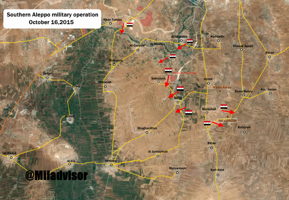
Southern Aleppo has started with the capture of Haddadin, Abtin, the army base there, and Sabigiyah. Source and Source.
Furthermore, I think we need to reavaluate of the towns of Balas and Kafr Abid are actually SAA held since Source and Source show it as Rebel held, with SAA inmoving as part of the ongoing offensive. MesmerMe (talk) 12:57, 16 October 2015 (UTC)
We cannot use maps to change ours. Furthermore no reliable source posted that Sabigiyah was taken by SAA just the base next to the village. I think that the map as it is, represent the situation on the ground at best of our knowledge.Paolowalter (talk) 14:10, 16 October 2015 (UTC)
Abtin just got changed to contested cause ahrar al sham tweet claimed they recaptured the Abtin farms with tons of killed and captured.Totholio (talk) 07:37, 18 October 2015 (UTC)
SAA advancing in Aleppo province and saize village of Al-Waddihi.http://www.syriahr.com/2015/10/%D9%85%D8%B9%D8%A7%D8%B1%D9%83-%D8%B9%D9%86%D9%8A%D9%81%D8%A9-%D9%88%D9%85%D8%B3%D8%AA%D9%85%D8%B1%D8%A9-%D9%81%D9%8A-%D8%B1%D9%8A%D9%81-%D8%AD%D9%84%D8%A8-%D8%A7%D9%84%D8%AC%D9%86%D9%88%D8%A8%D9%8A/
- SOHR: SAA control Al-Waddihi,Sabiqiyah,Abtin,Tell al-Shaheed,Qaddar and conflicting data about Shughaydilah where there is conflicting information about party that seizes the village of al- Shgaydalah which had been attacked by the rebels after seizing it by the regime forces. http://www.syriahr.com/en/2015/10/about-60-victims-killed-during-the-regime-forces-advancement-in-the-southern-countryside-of-aleppo/ http://www.syriahr.com/2015/10/%D8%B4%D8%B1%D9%8A%D8%B7-%D9%85%D8%B5%D9%88%D8%B1-%D9%8A%D8%B8%D9%87%D8%B1-%D9%85%D8%B9%D8%A7%D9%86%D8%A7%D8%A9-%D8%B3%D9%8A%D8%AF%D8%A9-%D8%B3%D9%88%D8%B1%D9%8A%D8%A9-%D9%88%D8%A3%D8%B7%D9%81%D8%A7/ So villages of Al-Waddihi,Sabiqiyah,Abtin,Tell al-Shaheed,Kaddar under control SAA and for now al- Shgaydalah contested. 46.200.207.127 (talk) 14:46, 18 October 2015 (UTC)
- Qaddara on map: http://wikimapia.org/#lang=en&lat=36.071025&lon=37.131901&z=13&m=b&show=/30808679/Kaddar This village under SAA on based data from SOHR 46.200.207.127 (talk) 15:08, 18 October 2015 (UTC)
Northern Homs Map
According to pro-goverment source this is the map that shows the situation of Northern Homs.46.99.111.37 (talk) 12:13, 17 October 2015 (UTC)
- We can't use maps as sources.MesmerMe (talk) 13:29, 17 October 2015 (UTC)
The source from this map is very credible as peto's maps but i think the situation now on our map looking like it. — Preceding unsigned comment added by 190.203.111.40 (talk) 14:56, 17 October 2015 (UTC)
Source make very wrong maps. Too many mistakes on maps which he make. Here map from Petro Lucem https://twitter.com/PetoLucem/status/654565310708756480 Also according to the rules of editing we cant use data only from maps without confirmation from relaible sources. 46.200.207.127 (talk) 15:41, 17 October 2015 (UTC)
Here map from more relaible source Al Masdar http://www.almasdarnews.com/article/complete-battle-map-of-syria-mid-october-update/#prettyPhoto http://www.almasdarnews.com/article/complete-battle-map-of-syria-mid-october-update/#prettyPhoto/0/ 46.200.207.127 (talk) 15:48, 17 October 2015 (UTC)
Outdated October 14 insurgents are losing ground every days too fast atm — Preceding unsigned comment added by 190.203.111.40 (talk) 18:25, 17 October 2015 (UTC)
Use talk page before editing
I do not want to enter another edit war, but I discussed the status of Mahajjah in the talk page and nobody questioned that it was unjustified ant not logic to be green so that we should revert to red that I did. AlAboud83 (a proxi of Alhanuty) rechanged back to green without any discussion: that goes against the rule governing this page. Furthremore he changed Abtin and Shegedla based on SOHR. The source says "in" but all other sources including many prorebeles reports "around" the towns, e.g. [1].
- In any case there was no discussion. Note tha the has never done any pro-government edit in his life.Paolowalter (talk) 22:26, 17 October 2015 (UTC)
- The problem aint that Alhanuty aint done a pro-goverment edit, why should he made it?!? We cannot force anyone to made an edit, the problem is his continuous vandalism, edits without sourcing, unjustified reverts, bad-faith misinterpretation of sources, use of unreliable sources,etc... since years ago. I dont know why he aint, but Im sure most other users would be blocked indefinitely if acted like him. Call me conspiranoid, but that only reforce my impression that there are different status of users in WP...--HCPUNXKID 23:19, 17 October 2015 (UTC)
I'll keep an eye on it. If either of the towns are changed to Lime, I'll revert them to whatever they were before.DaJesuZ (talk) 23:04, 17 October 2015 (UTC)
Why not simply report him I notice that all the recent edits have been deleted to protect someone from being reported! Suddenly they just skip to 20th of September????SyrianObserver2015 (talk) 10:44, 18 October 2015 (UTC)
before making accusations,i have changed my name from AlHanuty to AlAboud83,plus for Mahajjah reliable sources were brought to make the edit for it by Tradedia,but you wanted to revert it with no evidence,and you did.User:AlAboud83 (User talk:AlAboud83) 11:20, 18 October 2015 (UTC) and when i revert your unsourced edit,you complain,plus you are a new editor in 2014,i am here since 2012.User:AlAboud83 (User talk:AlAboud83) 11:20, 18 October 2015 (UTC) looks you have poor english skills Paolo:SOHR is more reliable than any tweet,plus it reports rebels spoil in abtin and SOHR confirms it its called content dispute,not Vandalism HCPs,you can't learn from your mistakes and blocks by admins. Paolowalter,you are the one who reverted it with no sources.Alhanuty (talk) 11:25, 18 October 2015 (UTC) Read this,and you will understand that it is rebel-held https://en.wikipedia.org/w/index.php?title=Talk:Cities_and_towns_during_the_Syrian_Civil_War&oldid=679950263#Mahajjah.2C_Daraa_province,and Tradedia agrees on it.Alhanuty (talk) 11:36, 18 October 2015 (UTC)
Who cares what Traedia thinks he might be the map creator, but supports isis and has vandalized the map many times in changing Hurwann and mahin to isis held countless times with no source. He also chand At Taff and Sha'rah with no source and they are rebel held on our map but every other map I have seen Sha' rah and At taff are government held, Tradiea has been active in manipulating the map and a prime supporter of isis terrorists. — Preceding unsigned comment added by 159.134.99.218 (talk) 12:52, 18 October 2015 (UTC)
- SyrianObserver2015 and others, you need to stop calling other users terrorists. You call other users terrorists ISIS beheaded supporters far more than others call you a regime Assadist. The truth is you do not have reliable sources to back your edits up. That's why you never provide sources for any of your edits. Since you don't have real arguments to support yourself, you revert to calling everyone you disagree with a terrorist beheader ISIS supporter. I wonder if you realize that this strategy is not getting you anywhere. Take Taff and Shariah for example. Pro-government Leith Fadel himself said he thought they were Islamist-held in his tweets, but you are so extreme that you yourself refuse to believe what Fadel is saying! Making partisan accusations against editors, specifically against the founder of this map, Tradedia, shows your bad intentions and desire to foist your biased point-of-view on the map. How ironic is that? The point is we need to stop calling each other names and start working with each other constructively to make this map better, more accurate, and more true-to-life. 2601:C7:8303:22DC:5432:9E6B:E28F:9B3 (talk) 15:37, 18 October 2015 (UTC)
Show me where I have made an color change edit that wasn't sourced? Sha'Rah and At Taff were changed based on a tweet from some random guy, not even Fadel said that. They were not a mentioned change and they had been held for a long time. I simply reverted the rapid unexplained and none appropriate source used. Anyone can make a tweeter account. I have made edits re-sizing objects because they are blocking other areas of interest that are covered by these areas insignificance. SyrianObserver2015 (talk) 18:40, 18 October 2015 (UTC)
- SyrianObserver2015, here is Leith's tweet saying At Taff is under rebel control, and here is his tweet saying Sha‘arah is under rebel control. I agree with you about Mahin and Huwwarin, but not these towns. Perhaps it was a result of confusion over these towns as a result of many reverts without mentioned sources. It seems to me Fadel was confirming what pro-Islamist rebel/terrorists/whatever-you-want-to-call-them supporters were saying, which was that At Taff and Sha‘arah were under rebel control. I don't mind your Sooda size edit, but the Wa'er edit was just wrong. That is a huge neighborhood that deserves a lot more than size 4. Well now that has been reverted. I am mainly asking you to stop your pro-government rhetoric in your posts. Do you see me saying "We can't assume good faith with a fucking dirty scumbag Assad regime supporter. So stop crying like a 10 year old child"? No! I have not seen such partisan rhetoric from the pro-rebel editors here (and yes there are such editors, I acknowledge that). Your repeated threats to shut down the map are useless and pointless, as it has survived a shutdown audit before, and can do it again. Just put sources in all of your edit summaries and none of us would be complaining right now. 2601:C7:8303:22DC:1DB4:BFDC:1999:782E (talk) 19:28, 18 October 2015 (UTC)
Ridiculous edits
Earlier, someone made this change. What is up with that? Why would you remove a siege icon that is backed up by al-Masdar, which clearly shows ISIS presence directly east of the town in question? This edit should be reverted, as it is unsourced. Also, the same user has made dozens of other unsourced edits before, like this, this, and these.
Second, what about this behavior? This user cut the size of a large town in half! Why might you ask? Surely he has a reliable source to back up his claims--no. He simply says "its less than 500 meter area that is contested chump.", referring to a person who reverted his edit. Wa'er is a huge town! Look at it! Thousands of people used to live there. Does that deserve to be size 4, do you think? Ridiculous.
Another example of the unsourced editing I am talking about. Look at this! Are we now just going to change entire towns from one group to another just because we feel like it? This is incredible! The high quality and standards this map is supposed to be held to are not being enforced! All of the previously mentioned edits need to be reverted, as they are unsourced. Everyone needs to provide a description of each edit in the edit summary as well as a source. 2601:C7:8303:22DC:1DB4:BFDC:1999:782E (talk) 02:06, 18 October 2015 (UTC)
- I agree Sakultah behaves very badly. Most of his changes must be reversed.Paolowalter (talk) 06:40, 18 October 2015 (UTC)
- Completely agree about al-Wa'er. It now looks like a tiny village to the west of Homs as opposed to a significant district on the city's outskirts Conservative Thinker (talk) 11:01, 18 October 2015 (UTC)
- The area in al Wa'ar (west of Homs city) is insignificant as it is 0.5 KM's squared of an area with around 600 Islamist insurgents, surrounded on all sides and out numbered massively. — Preceding unsigned comment added by 159.134.99.218 (talk) 12:39, 18 October 2015 (UTC)
- I agree in full of the bad behavior and even if they were right, sources should be given or discussion should be started. As for al Wa´ar I don´t know how many insurgents there are 300 or 1000, no idea. But if they were "insignificant", they would have been overrun a long time ago.Rhocagil (talk) 14:05, 18 October 2015 (UTC)
- Emphasis needs to be placed on the user Sakultah, who has just now made multiple edits without any sources in what amounts to edit warring. He has already been warned, and should be blocked from editing this page, as he has repeatedly violated the rules of editing even after being told not to. 2601:C7:8303:22DC:1DB4:BFDC:1999:782E (talk) 23:00, 18 October 2015 (UTC)
- I agree in full of the bad behavior and even if they were right, sources should be given or discussion should be started. As for al Wa´ar I don´t know how many insurgents there are 300 or 1000, no idea. But if they were "insignificant", they would have been overrun a long time ago.Rhocagil (talk) 14:05, 18 October 2015 (UTC)
Semi-protected edit request on 18 October 2015
 | It is requested that an edit be made to the extended-confirmed-protected module at Module:Syrian Civil War detailed map. (edit · history · last · links · sandbox · edit sandbox · sandbox history · sandbox last edit · sandbox diff · transclusion count · protection log) This template must be followed by a complete and specific description of the request, that is, specify what text should be removed and a verbatim copy of the text that should replace it. "Please change X" is not acceptable and will be rejected; the request must be of the form "please change X to Y".
The edit may be made by any extended confirmed user. Remember to change the |
Add lime northern siege icon "map-arcNN-lime.svg" to Jubb al Ahmar, which is a government held area per pro-government and reliable source: http://www.almasdarnews.com/article/islamist-rebels-attempt-to-recapture-jubb-al-ahmar-amid-the-syrian-armys-offensive-in-salma/ 2601:C7:8303:22DC:1DB4:BFDC:1999:782E (talk) 19:01, 18 October 2015 (UTC)
- The source is 5 days old now, if they had captured it we would hear and if they were still around it we would have heard, no point really yet, unless confirmed by elsewhere or a new fresh report. — Preceding unsigned comment added by SyrianObserver2015 (talk • contribs) 09:27, 19 October 2015 (UTC)
Is anybody reading this page?
#Bir Khalah and other things to fix! I spent quite a lot of time looking for thinks to fix, but I can't change it myself since I don't have autoconfirmed status. So, can I have the status or someone else will do the changes? --Hogg 22 (talk) 06:56, 19 October 2015 (UTC)
- If you can't edit the article and would like to request an edit, you can use the {{edit semi-protected}} template. clpo13(talk) 09:36, 19 October 2015 (UTC)
- Done. Paolowalter (talk) 16:54, 19 October 2015 (UTC)
South of Aleppo
Many news are flowing in about south-west of Aleppo AlMasdar alMadar SOHR SOHR. Summarizing: Khan Thuma and Kalidya contested [2], they are on the ALeppo main page; Al-Huwayz taken by SAA. TellQuhra[ taken by SAA. [http://wikimapia.org/#lang=de&lat=36.120752&lon=37.092590&z=14&m=b Munition Storage & Army Base taken by SAA (I guess). Honestly the information are not always clear. Do you agree on these changes?Paolowalter (talk) 10:35, 19 October 2015 (UTC)
- I trust your judgement. Rhocagil (talk) 12:47, 19 October 2015 (UTC)
Syrian Army and Hezbollah Capture Tal SyriaTel in Southern Aleppo.http://www.almasdarnews.com/article/breaking-syrian-army-and-hezbollah-capture-tal-syriatel-in-southern-aleppo/ 46.200.207.127 (talk) 13:49, 19 October 2015 (UTC)
Tal Syria Tell is a strategic hill around 7 kilometers west of Al Hader, it is not shown on the map, a lot of places are not shown on the map, only places really insignificant in ISIS/FSA/AL Nusrat control get added, the Government towns get deleted by the many insurgent supporters on this article.SyrianObserver2015 (talk) 17:46, 19 October 2015 (UTC)
- It's near al waddihi, but you are right, strategic and not shown. There is actually a dispute where it is.Totholio (talk) 18:03, 19 October 2015 (UTC)
- There is a SyriaTel here but it seems in a area controlled by SAA since long time. I cannot find another close to the front line.Paolowalter (talk) 18:29, 19 October 2015 (UTC)
East Aleppo
Isis confrims that they are still in controll of Muflisah,Dakwanah,Halabiyah here,also pro-regime source confirms this to here,Al-Masdar primary source is this guy Ibrahim Joudeh.46.99.68.133 (talk) 14:16, 19 October 2015 (UTC)
IS statement cannot be used in its favour. Maps cannot be use not even to support the opposite site. What is the point about Al Masdar? The latest info from AlMasdar states that Dakwanah is taken by SAA while Al-Mufliseh is still in IS hand with SAA on its outskirts. Halabiyah was taken some days before. SOHR speaks of clashes around al- Dekwani. Let's say that Dakwanah is on the front-line contested, Al-Mufliseh on the front line under IS control and Halabiyah most likely SAA control.Paolowalter (talk) 16:54, 19 October 2015 (UTC)
- No idea, this is why I highly doubt SOHR credibility(a lot of times masdar also) They got 0 source in IS/SAA, just guessing the casualties/progress.Totholio (talk) 18:04, 19 October 2015 (UTC)
Pro-rebels sources claim: Regime force controls village of Dakwanah and other villages nearby surroundings of Kweiris Airport and Thermal station after ISIS withdraw.https://twitter.com/abohafsalhamoe/status/656125309708804096 Assad's forces in control of villages Dakwanah and Baqisha less than 10 km from Kweiris military airport after the decline ISIS.https://twitter.com/Raman_Yusif/status/656166075122364416 https://twitter.com/saleelalmajd1/status/656139117164531712 46.200.207.127 (talk) 18:53, 19 October 2015 (UTC)
SAA launched a counter-assault from their positions at Burayjah in order to recapture western farms of Tal Sab’een and not only captured the western farms, but also captured hilltops overlooking of Tal Sab’een and forced ISIS to retreat further north. http://www.almasdarnews.com/article/cheetah-forces-press-further-in-east-aleppo-hilltops-overlooking-tal-sabeen-captured/ 46.200.207.127 (talk) 06:08, 20 October 2015 (UTC)
Mansoura
http://www.syriahr.com/en/2015/10/regime-forces-advances-in-al-ghab-valley/ — Preceding unsigned comment added by 2.87.204.184 (talk) 21:44, 19 October 2015 (UTC)
- SOHR claim that Mansoura Grain Silos under control of Regime forces. http://www.syriahr.com/en/2015/10/regime-forces-advances-in-al-ghab-valley/ 46.200.207.127 (talk) 05:21, 20 October 2015 (UTC)
Please add Al Jumaymah in S Aleppo
Please add Al Jumaymah in S Aleppo, based on Al-Masdar article. This pro-Assad news portal reports about rebels retreating from Balas to Al Jumaymah, which means the willage is definitively under rebel control. This area has too few villages on our map. --Hogg 22 (talk) 14:42, 20 October 2015 (UTC)
I did before I read your post. In anycase you can do it yourself.Paolowalter (talk) 17:41, 20 October 2015 (UTC)
- POST DELETED - Twitter is not a source, 46.200.207.127. Don't use it as one.DaJesuZ (talk) 23:22, 20 October 2015 (UTC)
- Undeleted, invalid sources shouldn't be used to edit, but shouldn't be deleted from the talk-page. There are few reasons to delete a comment on a talk page. In addition, twitter sources aren't necessarily bad, it's the person who makes the twitter post we should consider (here, Leithfadel). Banak (talk) 23:38, 20 October 2015 (UTC)
- POST DELETED - Twitter is not a source, 46.200.207.127. Don't use it as one.DaJesuZ (talk) 23:22, 20 October 2015 (UTC)
- Leith has been shown, on several occasions, regardless of his position as an editor for al-Masdar, to be biased and unreliable (based on his Twitter feed), going by it, without confirmation from al-Masdar, means there is a greater chance for inaccurate editing of the map. This guy's feed is not a source. Re-deleted. DaJesuZ (talk) 03:26, 21 October 2015 (UTC)
It is pretty obvious that Leith will post stuff on twitter before he has had it confirmed, not to mention some of his tweets are just intended as wind ups. With his pieces on al-Masdar he seems to be much more careful and while he might make the odd mistake there does seem to be a genuine attempt at accuracy. al-Masdar does report some rebel advances and recently as de-bunked some stories of more extravagant SAA advances. Therefore while I think it is right to use al-Masdar as a reliable source it would be a huge mistake to consider Leith's twitter account as reliable. Conservative Thinker (talk) 11:25, 21 October 2015 (UTC)
Kafr Dulbah and Tartiyah
Looks like i was in a cave for the last ten days. When did Kafr Dulbah moved from contested to red? the last info i can find online about it from RT (Pro-red)RT is That Kafr Dulbah is contested. (They stated the army is making progress in Kafr Dulbah which means they don't fully control it) if there is later news I can't find please inform me. Tartiyah on the other hand I heard no news of clashes overthere. waiting for answers Helmy1453 (talk) 17:00, 20 October 2015 (UTC)
Here is another Pro-red source (bousla states that RT claim advances in Kafr Dublah) just today stating advances for the SAA in Kafrdulbah and killing ,tens of terrorist bla bla bla. The point is if pre red states clashes and advances in the are how is it red already ??? If I get no reply by midday I will change it to contested Helmy1453 (talk) 17:19, 20 October 2015 (UTC)
If you have been absent, I am sorry for you but all changes were done following reliable sources. Therefore you are not going to change it unless new sources become available. The source you posted is in arabic, which I cannot read, and automatic translation ofetn confused 'inside' with 'around'. None of the usual sources posted any news such to require a change in the map. Tracking the sources that supported the changes can be a little time consuming but it is up to you if you want to check if they are good enough.Paolowalter (talk) 17:41, 20 October 2015 (UTC)
OK. fair enough. I will wait till a source in english states it, but many times I find sources in arabic with no equivelent in english. also those towns every one speels them his own way in englsih which make ssearch on google impossible where in arabic it is always spelled the same. But you will see that in a week or so we will here news from Kafr Dulbah that it is "captured" by the regime or clashes will hapen. let's wait and see. Helmy1453 (talk) 18:06, 20 October 2015 (UTC)
Rasm Hater west of Al-Ithriyah
I´m adding the tiny village Rasm Hater (as under SAA control) just 2 km west of Al-Ithriyah, because I think it´s important to show as much information as possible around strategic places such as Al-Ithriyah. Of course I can´t be 100% sure about who is in control, but I think it´s a fair assumption that it´s government held. If anyone has an argument about this, please post your opinion. Rhocagil (talk) 20:55, 20 October 2015 (UTC)
- I would say it is probably government-held. Good edit. — Preceding unsigned comment added by 2601:C7:8303:22DC:1DB4:BFDC:1999:782E (talk) 02:48, 21 October 2015 (UTC)
References to comments
Dear colleagues,
I propose to make it mandatory to put link to the source not [only] in the edit description, but also in comment after the changed line. As far as I understand, two dashes ( -- ) should work fine? Dr Bug (Vladimir V. Medeyko) 23:53, 20 October 2015 (UTC)
- I think the idea of putting comments after each line in the code might become tedious, but it is an interesting idea. I am all for making edit summaries and sources mandatory, as there is too much unsourced editing going on around here. 2601:C7:8303:22DC:1DB4:BFDC:1999:782E (talk) 02:44, 21 October 2015 (UTC)
The Waha Report?
Hi! Is http://wahareport.com/ considered reliable source? --Hogg 22 (talk) 08:25, 21 October 2015 (UTC)
- We can monitor and see. As far as I could see, it reports news correctly but nothing different from other sources.
It should be understood if it has sources on ground or if it just copies news from other sources.Paolowalter (talk) 09:03, 21 October 2015 (UTC)
- I'm asking because today's report says "Opposition and SAA forces clash in Bayt Awan, north of Latakia. Reports of casualties on both sides.", and Bayt Awan is red on our map. I will be bold and change it :). Feel free to revert it if You disagree. --Hogg 22 (talk) 13:44, 21 October 2015 (UTC)
Jabbul
Isis has retaken Jabbul 8 days ago and pro-regime source Al-Masdar didn't report that,but other pro-regime sources did.PetoLucem,here.46.99.17.6 (talk) 09:45, 21 October 2015 (UTC)
I saw the news but it is not available on what we condider reliable sources but only on map and twitter. Let keep an eye when and if it will be reported through reliable sources.Paolowalter (talk) 10:33, 21 October 2015 (UTC)
SAA probably withdraw for tactical reasons or something as we have heard nothing from either SOHR or Al-Masdar. Otherwise I think it´s very strange that two of the most pro-regime sources makes their maps without showing SAA presence in Jabbul. Rhocagil (talk) 11:07, 21 October 2015 (UTC)
SAA captured village of Tal Sabin south of Kuwairis Airport.source Also pro rebels source confirmed that Jabbul under control of SAA. https://twitter.com/Abboud11S/status/656581621840220160 46.200.207.127 (talk) 12:30, 21 October 2015 (UTC)
- Paolowalter which is that reliable source that we should wait to report this that didn't report it 1 week ago ? Al-Masdar?? that is reporting that the syrian army are only 1 village close to the airport or that of pro-rebels source who some are saying they captured Jabbul some say they recaptured Bashiqah!?.Tell me please.46.99.72.61 (talk) 16:02, 21 October 2015 (UTC)
- I cannot understand your question. Opinions on Jabbul differ even between pro-government outlets. It is reported that SAA pulled out without fighting (and therefore went unreported) to defend Tell Naam. We can also put it contested (in any case is next to the front line).Paolowalter (talk) 16:30, 21 October 2015 (UTC)
- Another advance toward the base http://www.almasdarnews.com/article/breaking-cheetah-forces-enters-sheikh-ahmad-4km-left-to-lift-the-siege-of-kuweires-airport/.Paolowalter (talk) 16:30, 21 October 2015 (UTC)
Somewhat pro OPP Agathocle deSyracuse has Jabbul contested on his (today 21 oct) map. Thou I have no idea how credible his maps are. Anyway it might be logical as Paolowalter says to put it contested.Rhocagil (talk) 17:47, 21 October 2015 (UTC)
SAA advance to South of Aleppo
SAA advanced and captured three villages to south of Aleppo(Sufayrah,Al-Qarassi and Al-Huwayz) village Balas contested.source 46.200.207.127 (talk) 11:51, 21 October 2015 (UTC)
Pro FSA source reported that the vilages Khan Touman and Balas under control by rebels and that Tal Al Mahruqat,Al Waddihi,Kadar,Tank Battalion,Al Sabaqiyah,Abtin,Tel Shaheed,Mount Azzan,Al Malahiya, Rasm Bakru under control of SAA.https://pbs.twimg.com/media/CRzAFStUYAAXgTZ.png:large 46.200.207.127 (talk) 13:18, 21 October 2015 (UTC)
Clashes between SAA and opposition forces in al-Eis http://wikimapia.org/#lang=en&lat=36.000924&lon=37.052078&z=13&show=/21654766/Al-Eis-%28Qinnasrin%29&search=Al-Hadher and al-Hadher http://wikimapia.org/#lang=en&lat=35.995508&lon=37.024441&z=13&show=/1696731/Al-Hadher&search=Al-Hadher, southwest of Aleppo. http://wahareport.com/2015/10/20/syria-daily-report-20102015/ 46.200.207.127 (talk) 18:33, 21 October 2015 (UTC)
SAA entered the imperative town of Sheikh Ahmad on the fringes of the Kuweires Military Airbase after intense firefights with ISIS.http://www.almasdarnews.com/article/breaking-cheetah-forces-enters-sheikh-ahmad-4km-left-to-lift-the-siege-of-kuweires-airport/ 46.200.207.127 (talk) 18:39, 21 October 2015 (UTC)
SAA captured villages of Tal Maflass http://wikimapia.org/#lang=en&lat=36.004257&lon=37.237988&z=13&m=b&show=/object/history/list/?object_type=1&id=33938090&lng=en ,Al-Ayoubi(including its surrounding farms) http://wikimapia.org/#lang=en&lat=36.004257&lon=37.237988&z=13&m=b&show=/object/history/list/?object_type=1&id=33938090&lng=en and Air Defense Battalion Base.http://www.almasdarnews.com/article/syrian-army-and-hezbollah-make-massive-gains-in-southern-aleppo-rebel-defenses-collapse/ 37.53.191.209 (talk) 16:29, 22 October 2015 (UTC)
SAA advance in southern countryside of Aleppo and captured Ghayghar, Al-Ajoubiyah Farms, Tal Mafless, Balas, and Jawar Al-Jahish after fierce clashes with Liwaa Suqour Al-Sham and Harakat Nour Al-Deen Al-Zinki. SAA also advance deep into the town of Kafr ‘Abid, which is located directly south of Balas and directly east of Kafr ‘Abish. So Kafr Abit still contested.http://www.almasdarnews.com/article/hezbollah-and-the-syrian-army-capture-several-sites-in-southern-aleppo-dagestani-emir-killed/ 37.52.24.103 (talk) 06:37, 23 October 2015 (UTC)
Whole of Al Zahara district captured by The Syrian Arab Army, Goverment forces
| Sockpuppet |
|---|
| The following discussion has been closed. Please do not modify it. |
|
Al Zahara captured by the legitimate Government Armed forces of the sovergn state of Syria: [3] http://www.almasdarnews.com/article/syrian-army-overpowers-jabhat-al-nusra-in-west-aleppo-entire-al-zahra-quarter-captured/ SyrianObserver2016 (talk) 13:21, 21 October 2015 (UTC)
I am sure that they mean what they mean and not what you think they mean. I am sure when they state "Whole of Al Zahara captured by the Syrian Arab Army" that is what they mean, not what you think they mean. SyrianObserver2016 (talk) 15:14, 21 October 2015 (UTC) Oh come on SyrianObserver2016, quit being such a propaganda-hothead. Jesus Christ ... "legitimate government armed forces of the sovergn (grammar mistake, mind you) state of Syria". Don't let my laugh. I read the article. For one, it's from Al Masdar. They claimed weeks ago that "rebels" didn't even enter Al-Zahra district during their offensive. Now, the rebels are pushed out? Strange, since, according to Al Masdar, they were never inside in the first place. Find some decent sources. — Preceding unsigned comment added by 84.24.43.183 (talk) 16:33, 21 October 2015 (UTC) |
Keep an eye on Mansour and it's grain south of it
I've seen pictures I trust of rebels taking control of grain south of Mansoura. these sources are Pro-Rebels and don't meet this page criteria so I am not posting them or updating anything, just saying keep aware if any reliable(per this page) sources anounce it. P.S looks like SOHR is in a coma lately they rarely report anything at all. all our updates lately are per Al-Masdar if this continues for long time we will need to find another Pro-Rebel reliable source other than SOHR, but that is a discusion for another day. Helmy1453 (talk) 17:45, 21 October 2015 (UTC)
East Hama
Does anybody know where al-Sa’en al-Aswad is SOHR? Paolowalter (talk) 20:40, 21 October 2015 (UTC)
- Al-Nusra and Jund Al-Aqsa launched a powerful assault on strategic town al-Sa’en in Hama Governorate but resulting in a series of intense firefights between the aforementioned Islamist group and NDF throughout the day they was unable to break-through the frontline defenses of Syrian troops and were forced to retreat to north in order to evade both the Syrian and Russian Air Forces that were lurking around the Hama-Idlib border.http://www.almasdarnews.com/article/important-battle-brewing-in-northern-hama-jabhat-al-nusra-attacks-al-siin/ 46.200.207.127 (talk) 06:09, 22 October 2015 (UTC)
I read the news. I just asked wher eis the town.Paolowalter (talk) 07:38, 22 October 2015 (UTC)
- Made the edit as an arch in the north, per ALMSDR news reporting the attack at the outskirts and a retreat north-ward.Ariskar (talk) 08:53, 22 October 2015 (UTC)
Paolowalter I don´t give much for this map but it points out the village you requested.Rhocagil (talk) 13:55, 23 October 2015 (UTC)
Semi-protected edit request on 21 October 2015
| It is requested that an edit be made to the extended-confirmed-protected module at Module:Syrian Civil War detailed map. (edit · history · last · links · sandbox · edit sandbox · sandbox history · sandbox last edit · sandbox diff · transclusion count · protection log) This template must be followed by a complete and specific description of the request, that is, specify what text should be removed and a verbatim copy of the text that should replace it. "Please change X" is not acceptable and will be rejected; the request must be of the form "please change X to Y".
The edit may be made by any extended confirmed user. Remember to change the |
Change "Hawsh Haju" to contested per reliable source: http://www.syriahr.com/en/2015/10/is-mobilize-its-soldiers-in-the-eastern-countryside-of-hama-and-ongoing-clashes-in-the-northern-countryside/
This source reported that the Islamist rebels and the government were clashing violently around Hawsh Haju near Homs. I think we should do a contested icon for that town, but a green siege icon would also do the job. " 2601:C7:8303:22DC:290C:A330:6FCA:AE4D (talk) 21:18, 21 October 2015 (UTC)
We cant marked Hawsh Haju as contested because SOHR only said that clashes near this town between Islamist rebels and Syrian troops. 46.200.207.127 (talk) 06:11, 22 October 2015 (UTC)
- Where is this place?Paolowalter (talk) 07:38, 22 October 2015 (UTC)
- http://wikimapia.org/#lang=en&lat=35.268608&lon=37.376175&z=12&m=b&show=/4560831/As-Si-in&search=Aleppo — Preceding unsigned comment added by MesmerMe (talk • contribs) 08:11, 22 October 2015 (UTC)
- That's As Si'in. Hawsh Haju is near Homs: wikimapia. --Hogg 22 (talk) 12:16, 22 October 2015 (UTC)
- http://wikimapia.org/#lang=en&lat=35.268608&lon=37.376175&z=12&m=b&show=/4560831/As-Si-in&search=Aleppo — Preceding unsigned comment added by MesmerMe (talk • contribs) 08:11, 22 October 2015 (UTC)
Will someone please make the edit?2601:C7:8303:22DC:862:D47F:F030:9061 (talk) 23:07, 22 October 2015 (UTC)
Sheikh Ahmad et al.
Dear colleagues,
don't you think that it would be right to add towns of
- Settlement name in latin script (population 2004, coordinates) date captured by SAA [references] (Settlement name in arabic script)
- Al-Nasiriyah (?, 36°6'30"N 37°28'20"E) 16.10 [4] (الناصرية)
- Al-Huwayjinah (1112, 36°6'40"N 37°26'35"E) 17.10.2015 [5] (حويجينة)
- Burayjah (1448, 36°7'17"N 37°28'59"E) 18.10.2015 [6] (بريجة)
- Dakwanah (688, 36°8'14"N 37°29'23"E) 18.10.2015 [7][8] (دكوانة)
- Tal Sab'in (890, 36°7'11"N 37°30'29"E) 20.10.2015 [9][10][11] (تلة الصبيحية) (AKA تل سبعين)
- Sheikh Ahmad (697, 36°9'4"N 37°31'46"E) 21.10.2015 [12] (شيخ احمد)
- Al-Halabiyah (1858, 36°8'22"N 37°28'0"E) 22.10.2015 [13] (الحلبية)
that were taken by the asadists on the respective dates according to Al-Masdar News? Yes, I undersand, that most of these are small towns and villages, but without them this part of the map look unreasonably empty and doesn't reflect the real situstion. (2004 population data according to [14]). Tal Na'am, for example, was put on the map, despite it's of no more importance that listed above. Dr Bug (Vladimir V. Medeyko) 17:31, 22 October 2015 (UTC)
There is nothing like 'asadists', it is called SAA, army or government foces. Those locations are located in the are covered by the detailed Aleppo map. There is a red dot on the map which I cannot understand what it is referring to. Tal Na'am is just outside the border of the map and was given its own point. The changes you require should be addressed to the Aleppo detailed page.Paolowalter (talk)
Al-Masdar map of N Homs
Check this map by Al-Masdar. Some of the rebel-held areas on Al-Masdar map are marked red on our map. It this just sloppy journalism or we can rely on this? --Hogg 22 (talk) 07:35, 23 October 2015 (UTC)
There is consensus on not using maps. I saw some discrepancies but they are not large, al-Halamuz seems the largest difference.Paolowalter (talk) 15:06, 23 October 2015 (UTC)
Rebels E and SE of al-Hamraa (NE of Hama)
I think we have some wrong data on the map. Please find city of al-Hamraa, NE of Hama, on Hama-Idlib border. All willages S and SE of al-Hamraa are red, but some pro-SAA sites are reporting rebel attacks in that area.
For example:
- syria 24 english: SAA Destroy TWO (2) Militant tanks EAST of Hamra
- Al-Masdar: [rebels] launched several attacks on the SAA’s positions along the Hama-Idlib border, targeting the Syrian Government controlled towns of Sukayk, ‘Abdel-‘Aziz, Al-Hamra, and Qal’at Rahiya on Friday morning. I believe ‘Abdel-‘Aziz and Qal’at Rahiya are willages Tall `Abd al `Aziz and Ruhayyah SE of al-Hamraa, see wikimapia. We have those willages on the map as Ruhayyah and Tall Abdelaziz.
Does anyone has more info on this area? --Hogg 22 (talk) 09:31, 23 October 2015 (UTC)
- I do not understand which changes you requires. The map is essentially correct Paolowalter (talk) 15:06, 23 October 2015 (UTC)
- And here it is: Iranian (pro-SAA) farsnews.com reports of airstrikews on rebel-held Tawal al-Dabaghin, which I found on wikimapia, just east of Al-Hamraa! I'm adding it to the map. --Hogg 22 (talk) 12:35, 23 October 2015 (UTC)
Syrian Arab Army, legitimate Government Forces capture more towns in Aleppo.
| Sockpuppet |
|---|
| The following discussion has been closed. Please do not modify it. |
|
Source for captured towns: [15] Sana: "Army units, in cooperation with the popular defense groups, established control over al-Huweiz and al-Qarasi villages in the southwestern countryside of Aleppo province, a military source announced." — Preceding unsigned comment added by SyrianObserver2016 (talk • contribs) 13:49, 23 October 2015 (UTC) Already turned red some days ago.Paolowalter (talk) 15:06, 23 October 2015 (UTC) |
Aleppo maps
There are two maps of Aleppo, but the first primary one does not show the so called- ammunition storage base as a goverment held territory while the other does. Both are created by MrPenguin20. In addition, the Rif-Aleppo map, Maryamayn is indicated as rebel-held and KafrAbid contested, showing rebel advatage. Is it true ? What do we know about the infarntry school ? Pro-gov. sources don't mention it's under SAA control. Oroszka (talk) 15:26, 23 October 2015 (UTC)
- As far as we know, the infantry academy is still under Islamic State control, so the map looks a little off in that area. Regime forces haven't been mentioned to've entered the academy, but have been in its vicinity, and to the east of it for days. DaJesuZ (talk) 19:23, 23 October 2015 (UTC)
Aleppo supply road cut
Here is a twitter post from a very reputable source (a page run by numerous well-known mapmakers) https://twitter.com/IUCAnalysts/status/657547319181709312
Here is a post from an IS source (assuming it's IS at least) displaying that they defeated an attempted Government counterattack. https://twitter.com/maghrebiwtis/status/657649089300049920
Here is an article from a source of unknown bias outlining the situation. I am not an Arabic reader by the way, so someone would have to translate for me. https://a3maqagency.wordpress.com/2015/10/23/%D8%A7%D9%86%D9%81%D9%88%D8%AC%D8%B1%D8%A7%D9%81%D9%8A%D9%83-%D9%82%D8%B7%D8%B9-%D8%B7%D8%B1%D9%8A%D9%82-%D8%A5%D9%85%D8%AF%D8%A7%D8%AF%D8%A7%D8%AA-%D8%A7%D9%84%D9%86%D8%B8%D8%A7%D9%85-%D8%A7%D9%84/ — Preceding unsigned comment added by 76.126.188.171 (talk) 05:23, 24 October 2015 (UTC)
- The Syrian regime is suffering from a manpower shortage, so an advance by both the rebels and Islamic State like this is very possible (however, this is simply my point of view, and POV edits are not allowed), but that would mean we have several town and cities marked incorrectly. The Arabic source you provided states that the Islamic State has severed the Syrian government's supply lines to Aleppo. I have no idea if this is true, but keep an eye out for more stories about it. This would be a massive development, and would influence the battle for Aleppo city, massively. DaJesuZ (talk) 08:37, 24 October 2015 (UTC)
Firstly this pro ISIS source https://a3maqagency.wordpress.com/2015/10/23/%D8%A7%D9%86%D9%81%D9%88%D8%AC%D8%B1%D8%A7%D9%81%D9%8A%D9%83-%D9%82%D8%B7%D8%B9-%D8%B7%D8%B1%D9%8A%D9%82-%D8%A5%D9%85%D8%AF%D8%A7%D8%AF%D8%A7%D8%AA-%D8%A7%D9%84%D9%86%D8%B8%D8%A7%D9%85-%D8%A7%D9%84/ And more reliable source reported that the Syrian Army Reopens the Ithriyah-Salamiyah Road in East Hama After Defeating ISIS. http://www.almasdarnews.com/article/breaking-syrian-army-reopens-the-ithriyah-salamiyah-road-in-east-hama-after-defeating-isis/ 91.124.122.78 (talk) 11:30, 24 October 2015 (UTC)
- This very source clearly states that IS holds parts of the Aleppo-Khanasser Hghway: "While the Syrian Armed Forces were successful in the aforementioned military endeavor, the Syrian Government’s main supply route along the Aleppo-Khanasser Highway that leads to the Aleppo Governorate remains cutoff by ISIS; this report has been confirmed by multiple sources from the Syrian Arab Army and National Defense Forces in the Hama Governorate. As long as ISIS has control of the Ithriyah-Khanasser Road, the Syrian Armed Forces will not have direct access to the imperative Aleppo-Khanasser that leads to the Aleppo Governorate’s provincial capital." 84.138.74.98 (talk) 12:38, 24 October 2015 (UTC)
SAA advance in Latakia province
SAA capture of Kataf Al-Ghaddar and have advanced inside the strategic city of Salma, capturing several building blocks and hilltops from the Islamist rebels, while also minimizing their losses at this volatile front. http://www.almasdarnews.com/article/syrian-army-special-forces-sweep-through-the-hills-surrounding-the-strategic-city-of-salma/ 91.124.122.78 (talk) 11:32, 24 October 2015 (UTC)
Aleppo changes
Rebels have retaken the villages of Al-Qarassi and Ayyubid yesterday and today. Those two villages are shown as SAA held on this map. We should change them to green. Source: http://www.petercliffordonline.com/syria-iraq-news-5/
The road between Khanassir and Aleppo has been cut by Islamic State fighters. Fighting is ongoing, but the sources are clear: the road is closed. We should make the red dots for the supply road black. Source: http://uk.reuters.com/article/2015/10/24/uk-mideast-crisis-syria-aleppo-idUKKCN0SI08U20151024 Source: http://www.muscatdaily.com/Archive/Gcc/Syria-army-battles-to-retake-Aleppo-supply-line-from-IS-4dn6 Source: http://www.reuters.com/article/2015/10/23/us-mideast-crisis-syria-idUSKCN0SH2D520151023 — Preceding unsigned comment added by 84.31.204.195 (talk) 12:42, 24 October 2015 (UTC)
This source too biased pro rebel source.http://www.petercliffordonline.com/syria-iraq-news-5/ Also Syrian Army Reopens the Ithriyah-Salamiyah Road in East Hama After Defeating ISIS.http://www.almasdarnews.com/article/breaking-syrian-army-reopens-the-ithriyah-salamiyah-road-in-east-hama-after-defeating-isis/ http://isis.trendolizer.com/2015/10/breaking-syrian-army-reopens-the-ithriyah-salamiyah-road-in-east-hama-after-defeating-isis.html 91.124.122.78 (talk) 15:09, 24 October 2015 (UTC)
Only Islamic State members, speaking to Reuters via internet from inside Syria, said their group had taken control of the road southeast of Aleppo. But SOHR only reported about fierce fighting between Syrian government forces and Islamic State in area of this road.http://www.reuters.com/article/2015/10/24/us-mideast-crisis-syria-aleppo-idUSKCN0SI08N20151024 So we not confirmations from reliable sources that ISIS captured some part of this road. The road was closed due to the clashes but not under the control of ISIS. But reliable source clear said that the Syrian Army Reopens the Ithriyah-Salamiyah Road in East Hama After Defeating ISIS.http://www.almasdarnews.com/article/breaking-syrian-army-reopens-the-ithriyah-salamiyah-road-in-east-hama-after-defeating-isis/ 91.124.122.78 (talk) 15:22, 24 October 2015 (UTC)
Alright, so this means that we can't use Al-Masdar as a source when "members of the Syrian Army claim to have taken a town"? Because we used some of those articles last week to make changes in Hama governorate? If your line of reasoning is solid, we can only use direct statements from sources on the ground in the area.
- IS took TWO sections of the highway near Ithriyah. One section between Ithriyah and Salamniyah and one section between Ithriyah and Khanaser. The Al-Masdar article clearly states that SAA retook only the section between Ithriyah and Salamniyah but that IS still controls parts of the highways between Ithriyah and Khanaser! 84.138.74.98 (talk) 16:25, 24 October 2015 (UTC)
Assad's forces control Tel Ambassador from the nearby village of Jabboul after another against ISIS. https://twitter.com/24Aleppo/status/657958483917197313 91.124.122.78 (talk) 16:56, 24 October 2015 (UTC)
- Pro-SAA tweets are not a reliable source. 84.138.74.98 (talk) 16:59, 24 October 2015 (UTC)
Sources for Idlib changes
I've seen some changes in the past few days. I have some questions about them:
- Which source was used to make the town of Al Taman'ah (east of Khan Shaykun, Idlib) contested between the FSA and Jabhat al-Nusra?
- Which source was used to make Tell Al-Teri red? — Preceding unsigned comment added by 84.24.43.183 (talk) 15:59, 24 October 2015 (UTC)
There was heavy fighting between the moderates in Taman'ah and today jund al aqsa left jaish al fateh cause they are too moderate for them. More moderate infighting soon.Totholio (talk) 16:42, 24 October 2015 (UTC)
User: Sakultah
User Sakultah is on a source-less editing rampage. More then ten non sourced edits the last week (did not ever give a sourced edit). Latest Ex; 1, 2, 3, 4, 5. Can somebody that knows how block this editor. Rhocagil (talk) 16:30, 24 October 2015 (UTC)
- Start-Class military history articles
- Start-Class Middle Eastern military history articles
- Middle Eastern military history task force articles
- List-Class Syria articles
- Low-importance Syria articles
- WikiProject Syria articles
- List-Class WikiProject Cities articles
- All WikiProject Cities pages
- Wikipedia extended-confirmed-protected edit requests