
Akron Township, Wilkin County, Minnesota: Difference between revisions
m Consolidate duplicate references expanded in last edit |
Rescuing 1 sources and tagging 0 as dead. #IABot (v1.2.4) |
||
| Line 77: | Line 77: | ||
|area_code = |
|area_code = |
||
|blank_name = [[Federal Information Processing Standard|FIPS code]] |
|blank_name = [[Federal Information Processing Standard|FIPS code]] |
||
|blank_info = 27-00550<ref name="GR2">{{cite web|url=http://factfinder2.census.gov|publisher=[[United States Census Bureau]]|accessdate=2008-01-31|title=American FactFinder}}</ref> |
|blank_info = 27-00550<ref name="GR2">{{cite web|url=http://factfinder2.census.gov |publisher=[[United States Census Bureau]] |accessdate=2008-01-31 |title=American FactFinder |deadurl=yes |archiveurl=https://web.archive.org/web/20130911234518/http://factfinder2.census.gov |archivedate=2013-09-11 |df= }}</ref> |
||
|blank1_name = [[Geographic Names Information System|GNIS]] feature ID |
|blank1_name = [[Geographic Names Information System|GNIS]] feature ID |
||
|blank1_info = 0663393<ref name="GR3">{{cite web|url=http://geonames.usgs.gov|accessdate=2008-01-31|title=US Board on Geographic Names|publisher=[[United States Geological Survey]]|date=2007-10-25}}</ref> |
|blank1_info = 0663393<ref name="GR3">{{cite web|url=http://geonames.usgs.gov|accessdate=2008-01-31|title=US Board on Geographic Names|publisher=[[United States Geological Survey]]|date=2007-10-25}}</ref> |
||
Revision as of 18:49, 6 October 2016
Akron Township, Minnesota | |
|---|---|
| Country | United States |
| State | Minnesota |
| County | Wilkin |
| Area | |
| • Total | 35.5 sq mi (91.9 km2) |
| • Land | 35.5 sq mi (91.8 km2) |
| • Water | 0.0 sq mi (0.1 km2) |
| Elevation | 1,053 ft (321 m) |
| Population (2000) | |
| • Total | 153 |
| • Density | 4.3/sq mi (1.7/km2) |
| Time zone | UTC-6 (Central (CST)) |
| • Summer (DST) | UTC-5 (CDT) |
| FIPS code | 27-00550[1] |
| GNIS feature ID | 0663393[2] |
Akron Township is a township in Wilkin County, Minnesota, United States. The population was 153 at the 2000 census.
Geography
According to the United States Census Bureau, the township has a total area of 35.5 square miles (92 km2); 35.5 square miles (92 km2) of it is land and 0.04 square miles (0.10 km2) of it (0.08%) is water.
Demographics
As of the census[1] of 2000, there were 153 people, 47 households, and 42 families residing in the township. The population density was 4.3 people per square mile (1.7/km²). There were 53 housing units at an average density of 1.5/sq mi (0.6/km²). The racial makeup of the township was 98.04% White, and 1.96% from two or more races.
There were 47 households out of which 46.8% had children under the age of 18 living with them, 87.2% were married couples living together, 2.1% had a female householder with no husband present, and 10.6% were non-families. 8.5% of all households were made up of individuals and 4.3% had someone living alone who was 65 years of age or older. The average household size was 3.26 and the average family size was 3.48.
In the township the population was spread out with 33.3% under the age of 18, 7.2% from 18 to 24, 20.9% from 25 to 44, 27.5% from 45 to 64, and 11.1% who were 65 years of age or older. The median age was 38 years. For every 100 females there were 84.3 males. For every 100 females age 18 and over, there were 100.0 males.
The median income for a household in the township was $43,125, and the median income for a family was $43,125. Males had a median income of $28,750 versus $10,000 for females. The per capita income for the township was $15,022. About 14.6% of families and 17.7% of the population were below the poverty line, including 19.6% of those under the age of eighteen and none of those sixty five or over.
References
- ^ a b "American FactFinder". United States Census Bureau. Archived from the original on 2013-09-11. Retrieved 2008-01-31.
{{cite web}}: Unknown parameter|deadurl=ignored (|url-status=suggested) (help) - ^ "US Board on Geographic Names". United States Geological Survey. 2007-10-25. Retrieved 2008-01-31.
Municipalities and communities of Wilkin County, Minnesota, United States | ||
|---|---|---|
| Cities | 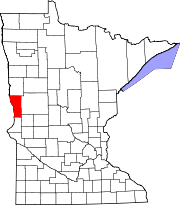 | |
| Townships | ||
| Unincorporated communities | ||
| Footnotes | ‡This populated place also has portions in an adjacent county or counties | |