De Koog: Difference between revisions
No edit summary Tag: Mobile app edit |
Rescuing 1 sources and tagging 0 as dead. #IABot (v1.2.7.1) |
||
| Line 27: | Line 27: | ||
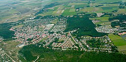
[[File:dekoog.JPG|250px|left|thumb|Aerial of De Koog, in north-east direction]] |
[[File:dekoog.JPG|250px|left|thumb|Aerial of De Koog, in north-east direction]] |
||
In 2001, the town of De Koog had 775 inhabitants. The built-up area of the town was 0.36 km², and contained 429 residences.<ref name="CBS">Statistics Netherlands (CBS), ''Bevolkingskernen in Nederland 2001'' |
In 2001, the town of De Koog had 775 inhabitants. The built-up area of the town was 0.36 km², and contained 429 residences.<ref name="CBS">Statistics Netherlands (CBS), ''Bevolkingskernen in Nederland 2001'' {{cite web|url=http://www.cbs.nl/nl-NL/menu/themas/milieu-natuur-ruimte/ruimte/publicaties/cartografie-geografie/geografische-data/2001-bevolkingskernen-in-nederland.htm |title=Archived copy |accessdate=2007-01-24 |deadurl=yes |archiveurl=https://web.archive.org/web/20060319070600/http://www.cbs.nl/nl-NL/menu/themas/milieu-natuur-ruimte/ruimte/publicaties/cartografie-geografie/geografische-data/2001-bevolkingskernen-in-nederland.htm |archivedate=2006-03-19 |df= }}. Statistics are for the continuous built-up area.</ref> The slightly larger statistical district "De Koog" has a population of around 1000.<ref name="CBS2">Statistics Netherlands (CBS), ''Gemeente Op Maat 2004: Texel'' [http://www.cbs.nl/nl-NL/menu/themas/nederland-regionaal/nederland-regionaal/publicaties/gemeente-op-maat/2004/alfabet/T/2004-texel.htm].</ref> |
||
[[Image:Church in de koog.JPG|left|250px|thumb|Church in the centre of De Koog]] |
[[Image:Church in de koog.JPG|left|250px|thumb|Church in the centre of De Koog]] |
||
Revision as of 01:02, 9 December 2016
De Koog | |
|---|---|
 The town centre (dark green) and the statistical district (light green) of De Koog in the municipality of Texel. | |
 | |
| Country | Netherlands |
| Province | North Holland |
| Municipality | Texel |
| Population | 1,300 |
De Koog (53°5′52″N 4°45′46″E / 53.09778°N 4.76278°E) is a town in the Dutch province of North Holland. It is a part of the municipality of Texel, and lies about 17 km north of Den Helder. It is the chief centre of tourism on the island, surrounded with many hotels and campgrounds. The village is located on the North Sea coast of the island. Only two narrow lines of dunes separate the village from the beach.
South of the village is a wooded area which is also popular with tourists. The information centre and museum about the Wadden Sea, Ecomare, are located here.

In 2001, the town of De Koog had 775 inhabitants. The built-up area of the town was 0.36 km², and contained 429 residences.[1] The slightly larger statistical district "De Koog" has a population of around 1000.[2]

References
- ^ Statistics Netherlands (CBS), Bevolkingskernen in Nederland 2001 "Archived copy". Archived from the original on 2006-03-19. Retrieved 2007-01-24.
{{cite web}}: Unknown parameter|deadurl=ignored (|url-status=suggested) (help)CS1 maint: archived copy as title (link). Statistics are for the continuous built-up area. - ^ Statistics Netherlands (CBS), Gemeente Op Maat 2004: Texel [1].
