Dongan Hills station: Difference between revisions
m →External links: clean up; http→https for Google Books and other Google services using AWB |
Rescuing 2 sources and tagging 0 as dead. #IABot (v1.2.7.1) |
||
| Line 60: | Line 60: | ||
==External links== |
==External links== |
||
*[http://mta.info/nyct/sir/sirmap.htm Staten Island Railway station list] |
*[https://web.archive.org/web/20071227095438/http://www.mta.info:80/nyct/sir/sirmap.htm Staten Island Railway station list] |
||
*[http://mta.info/nyct/sir/sirinfo.htm Staten Island Railway general information] |
*[https://web.archive.org/web/20071203173341/http://www.mta.info:80/nyct/sir/sirinfo.htm Staten Island Railway general information] |
||
* [https://maps.google.com/?ie=UTF8&ll=40.589116,-74.095616&spn=0.003846,0.013679&z=17&layer=c&cbll=40.58907,-74.095521&panoid=1gzyosQJktLUCqKrL7DXKg&cbp=12,240.89,,0,3.09 Garretson Avenue entrance from Google Maps Street View] |
* [https://maps.google.com/?ie=UTF8&ll=40.589116,-74.095616&spn=0.003846,0.013679&z=17&layer=c&cbll=40.58907,-74.095521&panoid=1gzyosQJktLUCqKrL7DXKg&cbp=12,240.89,,0,3.09 Garretson Avenue entrance from Google Maps Street View] |
||
* [https://maps.google.com/?ll=40.588537,-74.096035&spn=0.006168,0.01134&layer=c&cbll=40.588589,-74.096128&panoid=dGm6tq1tlMNK_0WrN8x_pA&cbp=12,256.77,,0,6.81&t=m&z=17 Seaview Avenue entrance from Google Maps Street View] |
* [https://maps.google.com/?ll=40.588537,-74.096035&spn=0.006168,0.01134&layer=c&cbll=40.588589,-74.096128&panoid=dGm6tq1tlMNK_0WrN8x_pA&cbp=12,256.77,,0,6.81&t=m&z=17 Seaview Avenue entrance from Google Maps Street View] |
||
Revision as of 15:23, 15 December 2016
Dongan Hills | |||
|---|---|---|---|
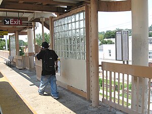
 Southbound platform | |||
| Station statistics | |||
| Address | Seaview Avenue & North Railroad Avenue Staten Island, NY 10304 | ||
| Borough | Staten Island | ||
| Locale | Dongan Hills | ||
| Coordinates | 40°35′20″N 74°05′45″W / 40.5890°N 74.0959°W | ||
| Division | [1] | ||
| Services | SIR Main Line | ||
| Structure | Embankment | ||
| Platforms | 2 side platforms | ||
| Tracks | 2 | ||
| Other information | |||
| Opened | April 23, 1860[2] | ||
| Rebuilt | 1933 | ||
| Accessible | |||
| Former/other names | Garretson's | ||
| Traffic | |||
| 2023 | [3] | ||
| Rank | out of 423[3] | ||
| |||
| |||
Dongan Hills is a Staten Island Railway station in the neighborhood of Dongan Hills, Staten Island, New York.
History
The station opened on April 23, 1860, with the opening of the Staten Island Railway from Vanderbilt's Landing to Eltingville.[2][4]
The station's original name was Garretson's, named after the original name of the neighborhood of the same name. The station's name changed after the neighborhood was renamed Dongan Hills. The name Garretson still can be found as there is a street that goes through the[5][6] Both names appeared on the October 16, 1921 timetable.[7]
Station layout
| P Platforms |
Side platform, doors will open on the right | |
| Southbound | ← Main toward Tottenville (Jefferson Avenue) | |
| Northbound | → Main toward St. George (Old Town) → | |
| Side platform, doors will open on the right | ||
| G | Street Level | Exit/Entrance |

It is located on an embankment at Seaview Avenue and Railroad Avenue on the main line. It has two side platforms and beige canopies.
This station is handicapped accessible in compliance with the Americans with Disabilities Act; with ramps at the south end that lead to Seaview Avenue. The marble wall at street level on the south end is a legacy of when the line was converted from grade level to the current embankment level today. The grade separation took place in 1933. The staircases at the north end lead to Garretson Avenue. Free parking is available on a small lot adjacent to the northbound platform, which is owned by the MTA, the agency that controls the rail line. The brick stationhouse is unusually positioned on the northbound side at platform level, unlike other SIR stationhouses which are usually located on street level. The Dongan Hills stationhouse had a ticket booth and benches until 1987, and then a vending machine for tokens until July 1997.
South of this station, there is an additional third track that once served a coal distributor. Grates between the rails led to chutes which now open into the backyards of homes that run alongside the embankment.
References
- ^ "Glossary". Second Avenue Subway Supplemental Draft Environmental Impact Statement (SDEIS) (PDF). Vol. 1. Metropolitan Transportation Authority. March 4, 2003. pp. 1–2. Archived from the original (PDF) on February 26, 2021. Retrieved January 1, 2021.
- ^ a b Irvin Leigh and Paul Matus (December 23, 2001). "SIRT The Essential History". p. 4. Retrieved 2009-03-03.
- ^ a b "Annual Subway Ridership (2018–2023)". Metropolitan Transportation Authority. 2023. Retrieved April 20, 2024.
- ^ Poster for opening of Staten Island Railway
- ^ - Staten Island Institute of Arts and Sciences, Volumes 1-3
- ^ Miscellaneous Documents of the Baltimore and Ohio Railroad Company and ..
- ^ [1]


