Fairy Loup: Difference between revisions
Appearance
Content deleted Content added
m →Bibliography: copyedit, already indirectly in category, refine cat, and AWB general fixes using AWB |
Rescuing 1 sources and tagging 0 as dead. #IABot (v1.2.7.1) |
||
| Line 12: | Line 12: | ||
==References== |
==References== |
||
{{reflist|refs= |
{{reflist|refs= |
||
<ref name=Dumping>{{cite web |
<ref name=Dumping>{{cite web|title=Dumping Ground |website=Eskdale & Liddesdale Advertiser |date=2008-07-16 |url=http://www.eladvertiser.co.uk/news/dumping-ground-1.204812 |accessdate=2015-02-27 |deadurl=yes |archiveurl=https://web.archive.org/web/20150227185505/http://www.eladvertiser.co.uk/news/dumping-ground-1.204812 |archivedate=2015-02-27 |df= }}</ref> |
||
<ref name=map>Ordnance Survey 1:25,000 scale Explorer map series, sheets 309-470</ref> |
<ref name=map>Ordnance Survey 1:25,000 scale Explorer map series, sheets 309-470</ref> |
||
<ref name=Walks>{{cite web |title=The Walks |work=Langholm Walks Project |url=http://www.langholmwalks.co.uk/walking6.htm |accessdate=2015-02-27}}</ref> |
<ref name=Walks>{{cite web |title=The Walks |work=Langholm Walks Project |url=http://www.langholmwalks.co.uk/walking6.htm |accessdate=2015-02-27}}</ref> |
||
Revision as of 08:24, 29 December 2016

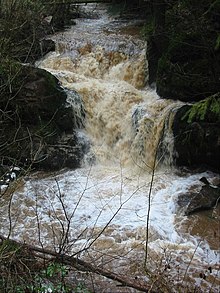
Fairy Loup is a waterfall located on Byre Burn, a tributary of River Esk, in Dumfries and Galloway, Scotland.[1]
The waterfall's name originates in a local legend of "a fairy having leaped from one side to the other",[2] and is an example of a regional tradition of associating small streams with fairies.[3] This waterfall was one of several features near Langholm described in the poetry of Hugh MacDiarmid.[4]
A 14.5-kilometre (9.0 mi) loop trail passing through Canonbie and Rowanburn gives access to the waterfall.[5] Fly-tipping has been a problem in the area.[6]
See also
References
- ^ Ordnance Survey 1:25,000 scale Explorer map series, sheets 309-470
- ^ Ordnance Survey 1848–1858, p. 146.
- ^ Hyslop & Hyslop 1912, p. 89.
- ^ Bold 1990, p. 18.
- ^ "The Walks". Langholm Walks Project. Retrieved 2015-02-27.
- ^ "Dumping Ground". Eskdale & Liddesdale Advertiser. 2008-07-16. Archived from the original on 2015-02-27. Retrieved 2015-02-27.
{{cite web}}: Unknown parameter|deadurl=ignored (|url-status=suggested) (help)
Bibliography
- Bold, Alan (1990). MacDiarmid: A Critical Biography. University of Massachusetts Press. ISBN 978-0-87023-714-0.
{{cite book}}: Invalid|ref=harv(help) - Ordnance Survey Name Books. Vol. Dumfriesshire Volume 4. Ordnance Survey. 1848–1858.
{{cite book}}: Unknown parameter|subscription=ignored (|url-access=suggested) (help) - Hyslop, John; Hyslop, Robert (1912). Langholm as It Was: A History of Langholm and Eskdale From the Earliest Times. Hills and Company. OCLC 25402682.
{{cite book}}: Invalid|ref=harv(help)
55°05′40″N 2°56′58″W / 55.09452°N 2.94953°W
