Hilton, South Australia: Difference between revisions
Rescuing 2 sources and tagging 0 as dead. #IABot (v1.3beta4) |
|||
| Line 18: | Line 18: | ||
| lga = City of West Torrens |
| lga = City of West Torrens |
||
| stategov = [[Electoral district of Ashford|Ashford]] <small>''(2011)''</small><ref>{{cite web|url=http://www.ecsa.sa.gov.au/apps/news/?year=2010 |title=Electoral Districts - Electoral District for the 2010 Election |author= |date= |work= |publisher=Electoral Commission SA |accessdate=20 April 2011 |deadurl=yes |archiveurl=https://web.archive.org/web/20110822191822/http://www.ecsa.sa.gov.au/apps/news/?year=2010 |archivedate=22 August 2011 }}</ref> |
| stategov = [[Electoral district of Ashford|Ashford]] <small>''(2011)''</small><ref>{{cite web|url=http://www.ecsa.sa.gov.au/apps/news/?year=2010 |title=Electoral Districts - Electoral District for the 2010 Election |author= |date= |work= |publisher=Electoral Commission SA |accessdate=20 April 2011 |deadurl=yes |archiveurl=https://web.archive.org/web/20110822191822/http://www.ecsa.sa.gov.au/apps/news/?year=2010 |archivedate=22 August 2011 }}</ref> |
||
| fedgov = [[Division of Hindmarsh|Hindmarsh]] <small>''(2011)''</small><ref>{{cite web |
| fedgov = [[Division of Hindmarsh|Hindmarsh]] <small>''(2011)''</small><ref>{{cite web|url=http://apps.aec.gov.au/esearch |title=Find my electorate |author= |date=15 April 2011 |work= |publisher=Australian Electoral Commission |accessdate=20 April 2011 |deadurl=yes |archiveurl=https://web.archive.org/web/20110430090535/http://apps.aec.gov.au/esearch |archivedate=30 April 2011 |df=dmy-all }}</ref> |
||
| near-n = [[Mile End, South Australia|Mile End]] |
| near-n = [[Mile End, South Australia|Mile End]] |
||
| near-ne = [[Mile End, South Australia|Mile End]] |
| near-ne = [[Mile End, South Australia|Mile End]] |
||
| Line 61: | Line 61: | ||
===Public transport=== |
===Public transport=== |
||
Hilton is serviced by public transport run by the [[Adelaide Metro]].<ref name=Metro>{{cite web |
Hilton is serviced by public transport run by the [[Adelaide Metro]].<ref name=Metro>{{cite web|url=http://timetables.adelaidemetro.com.au/ttsearch.php |title=Public Transport in Adelaide |author= |date=12 January 2011 |work=Adelaide Metro official website |publisher=Dept. for Transport, Energy and Infrastructure, Public Transport Division |accessdate=20 April 2011 |deadurl=yes |archiveurl=https://web.archive.org/web/20110426182058/http://timetables.adelaidemetro.com.au/ttsearch.php |archivedate=26 April 2011 |df=dmy-all }}</ref> The bus routes that serve Hilton are 163, 720, 720H and the J1. |
||
==See also== |
==See also== |
||
Revision as of 14:12, 2 April 2017
| Hilton Adelaide, South Australia | |||||||||||||||
|---|---|---|---|---|---|---|---|---|---|---|---|---|---|---|---|
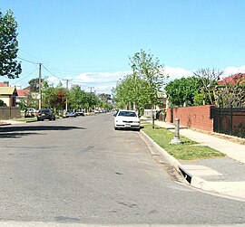
 Residential street in Hilton | |||||||||||||||
| Population | 807 (2006 census)[1] 793 (2001 Census)[2] | ||||||||||||||
| Established | c. 1849[3] | ||||||||||||||
| Postcode(s) | 5033[4] | ||||||||||||||
| Location | 2.8 km (2 mi) W of Adelaide city centre[4] | ||||||||||||||
| LGA(s) | City of West Torrens | ||||||||||||||
| State electorate(s) | Ashford (2011)[5] | ||||||||||||||
| Federal division(s) | Hindmarsh (2011)[6] | ||||||||||||||
| |||||||||||||||
Hilton is an inner western suburb of Adelaide, South Australia. It is located in the City of West Torrens, for which it is the council seat.
History
The land now covering the suburb of Hilton was received by Matthew Davenport Hill in 1839. About ten years later, The 'Village of Hilton' was laid out by his attorney, George Milner Stephen.[3]
The historic 1935 West Torrens Council Chambers are listed on the South Australian Heritage Register.[7]
Geography
Hilton is a rectangular suburb lying across Sir Donald Bradman Drive.[8]
Demographics
The 2006 Census by the Australian Bureau of Statistics counted 807 persons in Hilton on census night. Of these, 51.2% were male and 48.8% were female.[1]
The majority of residents (65.2%) are of Australian birth, with other common census responses being Greece (7.3%), England (3.6%) and China (2.4%).[1]
The age distribution of Hilton residents is skewed slightly higher than the greater Australian population. 71.2% of residents were over 25 years in 2006, compared to the Australian average of 66.5%; and 28.8% were younger than 25 years, compared to the Australian average of 33.5%.[1]
Community
The local newspaper is the Weekly Times Messenger. Other regional and national newspapers such as The Advertiser and The Australian are also available.[9]
Facilities and attractions
The West Torrens Civic Centre (council offices) are on the corner of Sir Donald Bradman Drive and Brooker Terrace. The Hamra Centre Library is located next door.[8]
Shopping and dining
Hilton Plaza shopping centre is located on the corner of Sir Donald Bradman Drive and Bagot Avenue.[8]
Transportation
Roads
Hilton is serviced by Sir Donald Bradman Drive, connecting the suburb to Adelaide City Centre.[8]
Public transport
Hilton is serviced by public transport run by the Adelaide Metro.[10] The bus routes that serve Hilton are 163, 720, 720H and the J1.
See also
References
- ^ a b c d Australian Bureau of Statistics (25 October 2007). "Hilton (State Suburb)". 2006 Census QuickStats. Retrieved 20 April 2011.
- ^ Australian Bureau of Statistics (9 March 2006). "Hilton (State Suburb)". 2001 Census QuickStats. Retrieved 20 April 2011.
- ^ a b "Place Names of South Australia". The Manning Index of South Australian History. State Library of South Australia. Retrieved 20 April 2011.
- ^ a b "Hilton, South Australia (Adelaide)". Postcodes-Australia. Postcodes-Australia.com. Retrieved 20 April 2011.
- ^ "Electoral Districts - Electoral District for the 2010 Election". Electoral Commission SA. Archived from the original on 22 August 2011. Retrieved 20 April 2011.
{{cite web}}: Unknown parameter|deadurl=ignored (|url-status=suggested) (help) - ^ "Find my electorate". Australian Electoral Commission. 15 April 2011. Archived from the original on 30 April 2011. Retrieved 20 April 2011.
{{cite web}}: Unknown parameter|deadurl=ignored (|url-status=suggested) (help) - ^ "West Torrens Council Chambers (1935 Building only)". South Australian Heritage Register. Department of Environment, Water and Natural Resources. Retrieved 11 September 2016.
- ^ a b c d Adelaide and surrounds street directory (47th ed.). UBD. 2009. ISBN 978-0-7319-2336-6.
{{cite book}}: Cite has empty unknown parameter:|coauthors=(help) - ^ "South Australian Newspapers". Newspapers.com.au. Australia G'day. Retrieved 20 April 2011.
- ^ "Public Transport in Adelaide". Adelaide Metro official website. Dept. for Transport, Energy and Infrastructure, Public Transport Division. 12 January 2011. Archived from the original on 26 April 2011. Retrieved 20 April 2011.
{{cite web}}: Unknown parameter|deadurl=ignored (|url-status=suggested) (help)
External links
- "City of West Torrens". Official website. City of West Torrens. Retrieved 20 April 2011.
